Enable Location

We need your location to show you interesting places around you

Discover nearby places

Find interesting locations and hidden gems around you

Precise directions

Get accurate directions and distances to places

Your location is never shared with other users. It's only used when you tap the location button.

Maidstone-on-the-Potomac

Log in to your account

Start exploring — it's free

Trusted by 62,527 travelers worldwide

Continue with Google
Continue with Apple
or

We will send you a code to connect

By continuing, you accept our Terms and Conditions and our Privacy Policy

Check your inbox

We've sent a pincode in your inbox. Please enter the code below.

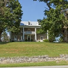
Maidstone-on-the-Potomac, human settlement in Berkeley County, West Virginia, United States of America

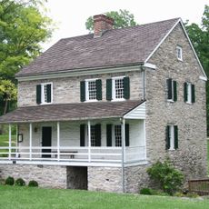
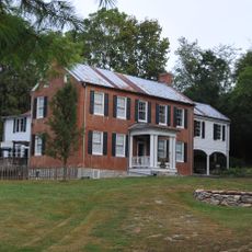
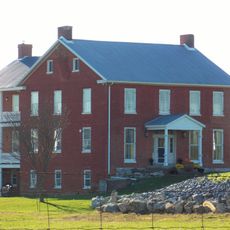
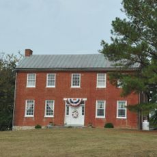
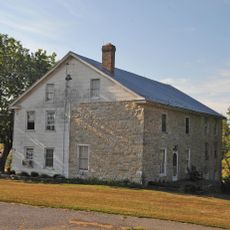
Maidstone-on-the-Potomac is a historic house and former plantation property in Berkeley County near Falling Waters, West Virginia. The stone and brick structure was built around 1741 and sits on a large parcel of land directly along the Potomac River, overlooking Williamsport, Maryland across the water.

The property was established in 1741 by Evan Watkins, who operated a ferry service across the Potomac River at this location. For decades, the crossing was used by significant figures including George Washington and later by thousands of soldiers during the Civil War who relied on the ferry for troop movements and supply transport.

The place served as a crossing point where travelers and traders from different regions met and exchanged news. The ferry and house formed a gathering spot where people on journeys between Virginia and Maryland paused and interacted.

The property is located along US Route 11, which runs directly through the grounds and crosses the Potomac River at this point. Visitors can walk the grounds to view the structure and surrounding landscape, though the house itself remains inaccessible due to fire damage sustained in 2009.

After the Battle of Gettysburg in 1863, approximately 70,000 Confederate soldiers retreated and crossed the Potomac River at this ferry location. This made the crossing a critical point during one of the largest military campaigns of the Civil War.

The community of curious travelers

AroundUs brings together thousands of curated places, local tips, and hidden gems, enriched daily by 60,000 contributors worldwide.

Start exploring
Location
GPS coordinates
39.59972,-77.83917
Latest update
February 9, 2026 08:21
Around this place
Chesapeake and Ohio Canal
United States of America

Chesapeake and Ohio Canal

9.4 km
Hager House
United States of America

Hager House

10.3 km
Hagerstown City Park
United States of America

Hagerstown City Park

10 km
Western Maryland Railway 202
United States of America

Western Maryland Railway 202

9.8 km
Springfield Farm
United States of America

Springfield Farm

2 km
Price-Miller House
United States of America

Price-Miller House

11 km
Wilson's Bridge
United States of America

Wilson's Bridge

6.5 km
Old Washington County Library
United States of America

Old Washington County Library

11 km
Elliot-Bester House
United States of America

Elliot-Bester House

10.9 km
Garden Hill
United States of America

Garden Hill

11 km
Wilson School
United States of America

Wilson School

6.4 km
Valentia
United States of America

Valentia

11 km
South Prospect Street Historic District
United States of America

South Prospect Street Historic District

10.7 km
Edward Colston House
United States of America

Edward Colston House

7.1 km
White Bush
United States of America

White Bush

4.4 km
Plumb Grove
United States of America

Plumb Grove

6.2 km
Williamsport Historic District
United States of America

Williamsport Historic District

1.6 km
Tammany
United States of America

Tammany

3.9 km
Houses At 16-22 East Lee Street
United States of America

Houses At 16-22 East Lee Street

10.9 km
Priscilla Strode Turner House
United States of America

Priscilla Strode Turner House

9.3 km
Marlowe Consolidated School
United States of America

Marlowe Consolidated School

2.3 km
Elmwood
United States of America

Elmwood

3.6 km
Charles Downs II House
United States of America

Charles Downs II House

5.6 km
Spring Mills Historic District
United States of America

Spring Mills Historic District

10.7 km
Rufus Wilson Complex
United States of America

Rufus Wilson Complex

6.4 km
Strode-Morrison-Tabler House and Farm
United States of America

Strode-Morrison-Tabler House and Farm

10.3 km
Washington County Museum of Fine Arts
United States of America

Washington County Museum of Fine Arts

10.1 km
Salisbury Street Bridge
United States of America

Salisbury Street Bridge

1.1 km
Show the full map
« Maidstone-on-the-Potomac - human settlement in Berkeley County, West Virginia, United States of America » is provided by Around Us (aroundus.com). Images and texts are derived from Wikimedia project under a Creative Commons license. You are allowed to copy, distribute, and modify copies of this page, under the conditions set by the license, as long as this note is clearly visible.

Discover hidden gems everywhere you go!

From secret cafés to breathtaking viewpoints, skip the crowded tourist spots and find places that match your style. Our app makes it easy with voice search, smart filtering, route optimization, and insider tips from travelers worldwide. Download now for the complete mobile experience.

Around Us App Screenshot

A unique approach to discovering new places

Le Figaro

All the places worth exploring

France Info

A tailor-made excursion in just a few clicks

20 Minutes

Around Us
Travel Guide & Maps
Download

Send to your phone

QR Code
1

Open the camera app on your mobile.

2

Point at the QR code with your camera. A notification will appear.

3

Tap the notification to open the link.