Enable Location

We need your location to show you interesting places around you

Discover nearby places

Find interesting locations and hidden gems around you

Precise directions

Get accurate directions and distances to places

Your location is never shared with other users. It's only used when you tap the location button.

Point of Rocks

Log in to your account

Start exploring — it's free

Trusted by 62,473 travelers worldwide

Continue with Google
Continue with Apple
or

We will send you a code to connect

By continuing, you accept our Terms and Conditions and our Privacy Policy

Check your inbox

We've sent a pincode in your inbox. Please enter the code below.

Point of Rocks, human settlement in Virginia, United States of America

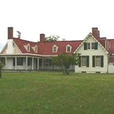
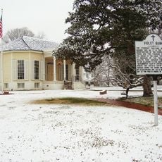
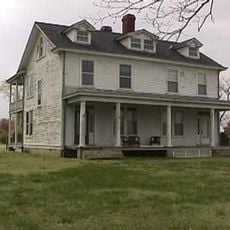
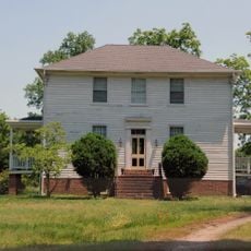
Point of Rocks is a small one-story house built in Greek Revival style in Chesterfield County, Virginia, constructed on a sturdy stone foundation with two large chimneys and four interior fireplaces. The building sits on approximately ten acres near the Appomattox River, close to sandstone cliffs that rise about 60 feet above the water and gave the property its name.

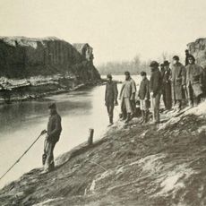
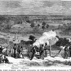
The house was built in 1840 by John Alexander Strachan and served as a lookout post and field hospital for Union General Benjamin F. Butler during the Civil War. After the war, the land housed freed slaves before the family reclaimed the property in 1866 and maintained ownership through the present day.

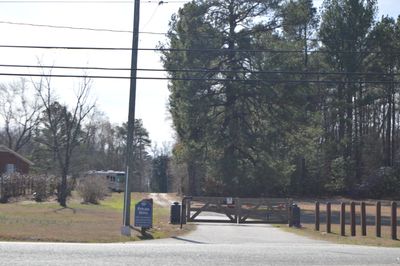
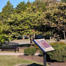
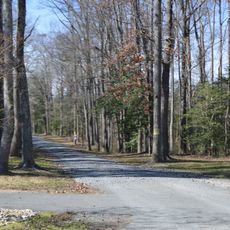
The main house is privately owned and not open for regular visits, but visitors can view parts of the property from the public road and explore the nearby Point of Rocks Park. The park encompasses approximately 188 acres along Enon Church Road in Chester and offers quiet river views plus remnants of Civil War earthworks.

Soldiers left personal belongings on the grounds that later rolled down the hill toward the river, becoming part of the site's physical history. The family documented these finds and preserves the memory of the people who fought and healed there.

The community of curious travelers

AroundUs brings together thousands of curated places, local tips, and hidden gems, enriched daily by 60,000 contributors worldwide.

Start exploring
Location
Architectural style
Greek Revival architecture
GPS coordinates
37.32170,-77.33810
Latest update
February 9, 2026 08:20
Around this place
Shirley Plantation
United States of America

Shirley Plantation

9.1 km
Henricus
United States of America

Henricus

6.2 km
Varina-Enon Bridge
United States of America

Varina-Enon Bridge

6.5 km
Benjamin Harrison Memorial Bridge
United States of America

Benjamin Harrison Memorial Bridge

10.1 km
Pocahontas Island, Virginia
United States of America

Pocahontas Island, Virginia

10.7 km
Dutch Gap
United States of America

Dutch Gap

6.4 km
Appomattox Manor
United States of America

Appomattox Manor

5.4 km
Kenner Army Health Clinic
United States of America

Kenner Army Health Clinic

9.3 km
United States of America

Henrico City

6.7 km
City Point National Cemetery
United States of America

City Point National Cemetery

4 km
Presquile National Wildlife Refuge
United States of America

Presquile National Wildlife Refuge

8.2 km
Beacon Theatre
United States of America

Beacon Theatre

4.9 km
Army Quartermaster Museum
United States of America

Army Quartermaster Museum

8.9 km
United States Army Women's Museum
United States of America

United States Army Women's Museum

8.8 km
United States of America

Dogham, Doggams

10.3 km
Violet Bank Museum
United States of America

Violet Bank Museum

10.7 km
Fort Clifton Archeological Site
United States of America

Fort Clifton Archeological Site

5.1 km
Hardens
United States of America

Hardens

10.5 km
City Point Historic District
United States of America

City Point Historic District

5.6 km
Swift Creek Mill
United States of America

Swift Creek Mill

7.8 km
Farmer's Rest
United States of America

Farmer's Rest

9.8 km
Downtown Hopewell Historic District
United States of America

Downtown Hopewell Historic District

4.8 km
Chesterfield Highlands Historic District
United States of America

Chesterfield Highlands Historic District

10.2 km
Hopewell Municipal Building
United States of America

Hopewell Municipal Building

4.9 km
The Village Grill
United States of America

The Village Grill

10.4 km
Violet Bank Historic District
United States of America

Violet Bank Historic District

10.5 km
Hatcher Island Bridge
United States of America

Hatcher Island Bridge

7.8 km
Jordan Point Light
United States of America

Jordan Point Light

10.2 km
Show the full map
« Point of Rocks - human settlement in Virginia, United States of America » is provided by Around Us (aroundus.com). Images and texts are derived from Wikimedia project under a Creative Commons license. You are allowed to copy, distribute, and modify copies of this page, under the conditions set by the license, as long as this note is clearly visible.

Discover hidden gems everywhere you go!

From secret cafés to breathtaking viewpoints, skip the crowded tourist spots and find places that match your style. Our app makes it easy with voice search, smart filtering, route optimization, and insider tips from travelers worldwide. Download now for the complete mobile experience.

Around Us App Screenshot

A unique approach to discovering new places

Le Figaro

All the places worth exploring

France Info

A tailor-made excursion in just a few clicks

20 Minutes

Around Us
Travel Guide & Maps
Download

Send to your phone

QR Code
1

Open the camera app on your mobile.

2

Point at the QR code with your camera. A notification will appear.

3

Tap the notification to open the link.