Enable Location

We need your location to show you interesting places around you

Discover nearby places

Find interesting locations and hidden gems around you

Precise directions

Get accurate directions and distances to places

Your location is never shared with other users. It's only used when you tap the location button.

Benjamin Harrison Memorial Bridge

Log in to your account

Start exploring — it's free

Trusted by 61,981 travelers worldwide

Continue with Google
Continue with Apple
or

We will send you a code to connect

By continuing, you accept our Terms and Conditions and our Privacy Policy

Check your inbox

We've sent a pincode in your inbox. Please enter the code below.

Benjamin Harrison Memorial Bridge

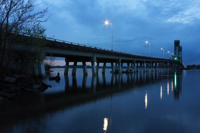
Benjamin Harrison Memorial Bridge, Vertical-lift road bridge in Prince George County, Virginia, US.

The Benjamin Harrison Memorial Bridge is a vertical-lift bridge crossing the James River between Prince George County and Charles City County near Hopewell. It uses a lifting mechanism in its towers to raise the span and allow riverboat traffic to pass underneath.

The bridge opened in 1966 to replace ferry service that previously crossed the James River. It was extensively rebuilt following a 1977 collision with the cargo ship SS Marine Floridian.

Named after Benjamin Harrison, the 23rd President of the United States, who maintained strong connections to his birth state of Virginia.

The bridge can be accessed via State Route 156 and serves as a key transportation corridor connecting the two counties. When riverboat traffic needs to pass, the lift mechanism raises the roadway temporarily, so traffic is stopped during these periods.

The bridge towers contain nesting boxes for peregrine falcons, supporting the reestablishment of this bird species across Virginia. Several breeding pairs have made their homes in these tower structures over the years.

The community of curious travelers

AroundUs brings together thousands of curated places, local tips, and hidden gems, enriched daily by 60,000 contributors worldwide.

Start exploring
Official opening
1966
GPS coordinates
37.31889,-77.22389
Latest update
December 9, 2025 18:46
Around this place
Shirley Plantation
United States of America

Shirley Plantation

4.5 km
Berkeley Plantation
United States of America

Berkeley Plantation

3.8 km
Westover Plantation
United States of America

Westover Plantation

4.8 km
Varina Farms
United States of America

Varina Farms

12.1 km
Flowerdew Hundred Plantation
United States of America

Flowerdew Hundred Plantation

10.9 km
Varina-Enon Bridge
United States of America

Varina-Enon Bridge

12.8 km
Malvern Hill
United States of America

Malvern Hill

8.9 km
Greenway Plantation
United States of America

Greenway Plantation

11.5 km
Appomattox Manor
United States of America

Appomattox Manor

4.7 km
Merchant's Hope
United States of America

Merchant's Hope

6.2 km
United States of America

Henrico City

12.1 km
Evelynton
United States of America

Evelynton

6.3 km
James River National Wildlife Refuge
United States of America

James River National Wildlife Refuge

10.2 km
City Point National Cemetery
United States of America

City Point National Cemetery

6.7 km
Presquile National Wildlife Refuge
United States of America

Presquile National Wildlife Refuge

5.9 km
Beacon Theatre
United States of America

Beacon Theatre

5.9 km
Upper Shirley
United States of America

Upper Shirley

4.3 km
Woodburn (Charles City, Virginia)
United States of America

Woodburn (Charles City, Virginia)

10.8 km
Edgewood Plantation and Harrison's Mill
United States of America

Edgewood Plantation and Harrison's Mill

3.5 km
Point of Rocks (Chester, Virginia)
United States of America

Point of Rocks (Chester, Virginia)

10.1 km
United States of America

Dogham, Doggams

4.9 km
Hardens
United States of America

Hardens

5.9 km
Prince George County Courthouse Historic District
United States of America

Prince George County Courthouse Historic District

12.2 km
City Point Historic District
United States of America

City Point Historic District

4.6 km
Downtown Hopewell Historic District
United States of America

Downtown Hopewell Historic District

5.8 km
Hopewell Municipal Building
United States of America

Hopewell Municipal Building

5.9 km
Jordan Point Light
United States of America

Jordan Point Light

652 m
Kippax Plantation
United States of America

Kippax Plantation

9.4 km
Show the full map
« Benjamin Harrison Memorial Bridge - Vertical-lift road bridge in Prince George County, Virginia, US » is provided by Around Us (aroundus.com). Images and texts are derived from Wikimedia project under a Creative Commons license. You are allowed to copy, distribute, and modify copies of this page, under the conditions set by the license, as long as this note is clearly visible.

Discover hidden gems everywhere you go!

From secret cafés to breathtaking viewpoints, skip the crowded tourist spots and find places that match your style. Our app makes it easy with voice search, smart filtering, route optimization, and insider tips from travelers worldwide. Download now for the complete mobile experience.

Around Us App Screenshot

A unique approach to discovering new places

Le Figaro

All the places worth exploring

France Info

A tailor-made excursion in just a few clicks

20 Minutes

Around Us
Travel Guide & Maps
Download

Send to your phone

QR Code
1

Open the camera app on your mobile.

2

Point at the QR code with your camera. A notification will appear.

3

Tap the notification to open the link.