Enable Location

We need your location to show you interesting places around you

Discover nearby places

Find interesting locations and hidden gems around you

Precise directions

Get accurate directions and distances to places

Your location is never shared with other users. It's only used when you tap the location button.

Merchant's Hope

Log in to your account

Start exploring — it's free

Trusted by 62,470 travelers worldwide

Continue with Google
Continue with Apple
or

We will send you a code to connect

By continuing, you accept our Terms and Conditions and our Privacy Policy

Check your inbox

We've sent a pincode in your inbox. Please enter the code below.

Merchant's Hope, human settlement in Virginia, United States of America

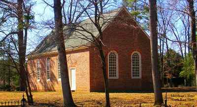
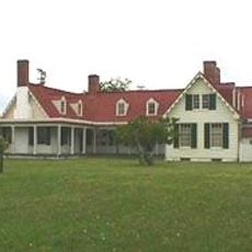
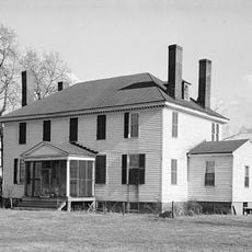
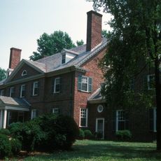
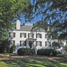
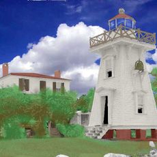
Merchant's Hope is a church in Prince George County, Virginia, built with brick walls laid in Flemish bond pattern and small window openings. The building features a steep roof with a flared gable, thick masonry construction, and a plain doorway with simple decorative arch details.

The church was likely built in the early to mid-1700s, though it was once thought to date from the late 1600s. It survived the Civil War when Union soldiers damaged the interior, and was later restored to show its colonial appearance.

The church shares a name connected to a plantation and an English ship that brought settlers to Virginia in the 1600s. Inside, painted wall tablets with religious texts and furnishings from different periods reflect how the community practiced worship across generations.

The church stands near the junction of Route 641 and Route 10, not far from Hopewell, and parts can be seen from the road. Keep in mind the building is private property with limited public access, so always respect the privacy of the grounds.

Inside, the church keeps a Bible printed in London in the 1600s called the Great Bible, which has been used here for many years. This rare colonial-era book makes the long history of the community tangible to visitors.

The community of curious travelers

AroundUs brings together thousands of curated places, local tips, and hidden gems, enriched daily by 60,000 contributors worldwide.

Start exploring
Location
GPS coordinates
37.26580,-77.20310
Latest update
February 9, 2026 08:23
Around this place
Shirley Plantation
United States of America

Shirley Plantation

10.7 km
Berkeley Plantation
United States of America

Berkeley Plantation

6.5 km
Westover Plantation
United States of America

Westover Plantation

7.9 km
Flowerdew Hundred Plantation
United States of America

Flowerdew Hundred Plantation

9.4 km
Benjamin Harrison Memorial Bridge
United States of America

Benjamin Harrison Memorial Bridge

6.2 km
Appomattox Manor
United States of America

Appomattox Manor

8.7 km
Kenner Army Health Clinic
United States of America

Kenner Army Health Clinic

13.1 km
Weyanoke, Virginia
United States of America

Weyanoke, Virginia

12.5 km
Evelynton
United States of America

Evelynton

8.3 km
James River National Wildlife Refuge
United States of America

James River National Wildlife Refuge

6.6 km
City Point National Cemetery
United States of America

City Point National Cemetery

9.5 km
Presquile National Wildlife Refuge
United States of America

Presquile National Wildlife Refuge

11.9 km
Beacon Theatre
United States of America

Beacon Theatre

8.6 km
Army Quartermaster Museum
United States of America

Army Quartermaster Museum

13 km
Upper Shirley
United States of America

Upper Shirley

10.2 km
Woodburn
United States of America

Woodburn

12.9 km
United States Army Women's Museum
United States of America

United States Army Women's Museum

12.9 km
Edgewood Plantation and Harrison's Mill
United States of America

Edgewood Plantation and Harrison's Mill

7.3 km
Fort Powhatan
United States of America

Fort Powhatan

11.1 km
United States of America

Dogham, Doggams

11 km
Upper Weyanoke
United States of America

Upper Weyanoke

12 km
Hardens
United States of America

Hardens

12.1 km
Prince George County Courthouse Historic District
United States of America

Prince George County Courthouse Historic District

8.9 km
City Point Historic District
United States of America

City Point Historic District

8.4 km
Downtown Hopewell Historic District
United States of America

Downtown Hopewell Historic District

8.7 km
Hopewell Municipal Building
United States of America

Hopewell Municipal Building

8.6 km
Jordan Point Light
United States of America

Jordan Point Light

5.6 km
Kippax Plantation
United States of America

Kippax Plantation

10.3 km
Show the full map
« Merchant's Hope - human settlement in Virginia, United States of America » is provided by Around Us (aroundus.com). Images and texts are derived from Wikimedia project under a Creative Commons license. You are allowed to copy, distribute, and modify copies of this page, under the conditions set by the license, as long as this note is clearly visible.

Discover hidden gems everywhere you go!

From secret cafés to breathtaking viewpoints, skip the crowded tourist spots and find places that match your style. Our app makes it easy with voice search, smart filtering, route optimization, and insider tips from travelers worldwide. Download now for the complete mobile experience.

Around Us App Screenshot

A unique approach to discovering new places

Le Figaro

All the places worth exploring

France Info

A tailor-made excursion in just a few clicks

20 Minutes

Around Us
Travel Guide & Maps
Download

Send to your phone

QR Code
1

Open the camera app on your mobile.

2

Point at the QR code with your camera. A notification will appear.

3

Tap the notification to open the link.