MAPS Air Museum

Log in to your account

AroundUs is a community-driven map of interesting places, built by curious explorers like you. It grows with every review, story, and photo you share.
Connect to save your favorite spots, contribute locations, and create personalized routes.
Continue with Google
Continue with Apple
Continue with X
Continue with Facebook
Continue with email
By continuing, you accept our Terms and Conditions and our Privacy Policy
Create an account
Add to collection
Map
Suggest a change
Share

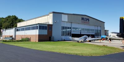
MAPS Air Museum, Aviation museum in Green, Ohio

The MAPS Air Museum in Green, Ohio displays over 50 aircraft that range from military fighters to transport planes spanning multiple decades. The exhibits fill a former airline hangar and cover different aspects of aviation history through their various themed sections.

The museum started in 1991 and moved to its current location in a former airline hangar in 2001. This expansion allowed the collection to grow significantly and enabled more educational activities for visitors.

The collection tells stories of military aviation and the people who flew these planes throughout different periods. Visitors can see how aircraft shaped warfare and what daily life was like for those who served in the skies.

The museum is easy to navigate and visitors can typically explore all the exhibits in about 2 to 3 hours. Most aircraft can be viewed both inside and outside, giving visitors a complete sense of each plane's scale and design.

The museum features the Medic's Corner exhibit, which showcases rarely seen medical equipment and supplies from the Vietnam War era. This often-overlooked section offers visitors a human perspective on military operations that goes beyond the aircraft themselves.

Location: Ohio

Inception: 1991

Accessibility: Wheelchair accessible

Opening Hours: Tuesday-Saturday 09:00-16:30; Sunday 11:30-16:00; January 01 off; easter off; May Monday[-1] off; July 04 off; September Monday[1] off; December 24-25 off;

Website: https://mapsairmuseum.org

GPS coordinates: 40.91690,-81.45450

Latest update: December 8, 2025 19:45

Photos
Around this place
Pro Football Hall of Fame
United States of America

Pro Football Hall of Fame

11.7 km
Tom Benson Hall of Fame Stadium
United States of America

Tom Benson Hall of Fame Stadium

11.8 km
Rubber Bowl
United States of America

Rubber Bowl

13.6 km
Goodyear Airdock
United States of America

Goodyear Airdock

12.9 km
President William McKinley National Memorial
United States of America

President William McKinley National Memorial

13.2 km
Paul Brown Tiger Stadium
United States of America

Paul Brown Tiger Stadium

14 km
Portage Lakes
United States of America

Portage Lakes

11.5 km
Central Catholic High School
United States of America

Central Catholic High School

13.9 km
John and Syd Dobkins House
United States of America

John and Syd Dobkins House

10.9 km
Palace Theatre
United States of America

Palace Theatre

14.5 km
Quail Hollow State Park
United States of America

Quail Hollow State Park

13.8 km
Portage Lakes State Park
United States of America

Portage Lakes State Park

10.4 km
Ridgewood Historic District
United States of America

Ridgewood Historic District

13 km
Canton Museum of Art
United States of America

Canton Museum of Art

14 km
Spring Hill Historic Home
United States of America

Spring Hill Historic Home

12.4 km
Saint Joseph's Roman Catholic Church
United States of America

Saint Joseph's Roman Catholic Church

14.7 km
Frank Mason Raymond House
United States of America

Frank Mason Raymond House

9.3 km
Akron Fulton International Airport Administration Building
United States of America

Akron Fulton International Airport Administration Building

14 km
Hall of Fame Bridge
United States of America

Hall of Fame Bridge

5.6 km
O. C. Barber Colt Barn
United States of America

O. C. Barber Colt Barn

14.3 km
St. Timothy's Protestant Episcopal Church
United States of America

St. Timothy's Protestant Episcopal Church

14.5 km
First Methodist Episcopal Church
United States of America

First Methodist Episcopal Church

14.4 km
Brooke and Anna E. Martin House
United States of America

Brooke and Anna E. Martin House

13.3 km
William McKinley Presidential Library and Museum
United States of America

William McKinley Presidential Library and Museum

13.4 km
Limbach Block Historic District
United States of America

Limbach Block Historic District

14.8 km
Lions Lincoln Theatre
United States of America

Lions Lincoln Theatre

14.5 km
Spring Hill Historic Home & Underground Railroad Site
United States of America

Spring Hill Historic Home & Underground Railroad Site

12.4 km
Wingfoot Lake State Park
United States of America

Wingfoot Lake State Park

13.7 km
Show the full map
Reviews

Visited this place? Tap the stars to rate it and share your experience / photos with the community! Try now! You can cancel it anytime.

« MAPS Air Museum - Aviation museum in Green, Ohio » is provided by Around Us (aroundus.com). Images and texts are derived from Wikimedia project under a Creative Commons license. You are allowed to copy, distribute, and modify copies of this page, under the conditions set by the license, as long as this note is clearly visible.

Discover hidden gems everywhere you go!

From secret cafés to breathtaking viewpoints, skip the crowded tourist spots and find places that match your style. Our app makes it easy with voice search, smart filtering, route optimization, and insider tips from travelers worldwide. Download now for the complete mobile experience.

Around Us App Screenshot

A unique approach to discovering new places

Le Figaro

All the places worth exploring

France Info

A tailor-made excursion in just a few clicks

20 Minutes