Chest opened
+${chestReward.xp} XP
Explorer
NOUVEAU ×${chestReward.collectible.quantity}
tapez pour fermer
Chest locked

Open chests in the app

Around Us is built for your phone — chests unlock when you walk, explore and capture nearby places.

Enable Location

We need your location to show you interesting places around you

Discover nearby places

Find interesting locations and hidden gems around you

Precise directions

Get accurate directions and distances to places

Your location is never shared with other users. It's only used when you tap the location button.

Log in to your account

Start exploring — it's free

Trusted by 72,926 travelers worldwide

Continue with Google
Continue with Apple
or

We will send you a code to connect

By continuing, you accept our Terms and Conditions and our Privacy Policy

Check your inbox

We've sent a pincode in your inbox. Please enter the code below.

Niday Place State Forest
Discussion Reviews Photo
1.8k Popularity

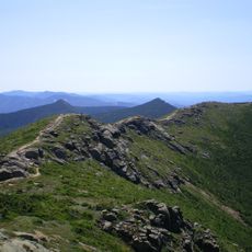
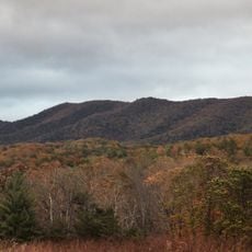
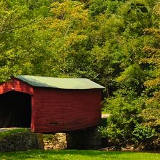
Niday Place State Forest, State forest at John's Creek Mountain in Craig County, Virginia

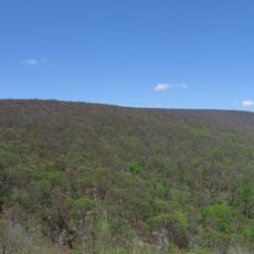
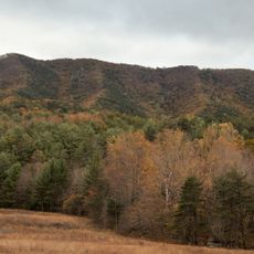
Niday Place State Forest is a protected woodland area covering about 254 acres of mountain hardwoods on John's Creek Mountain in Craig County. The forest provides habitat for diverse native plants and animals throughout its terrain.

The forest was established in 1989 when Anne H. Cutler from Williamsburg donated the land to create a protected natural area. This gift secured the woodland as a permanent conservation site.

The Virginia Department of Forestry manages this IUCN category IV site as both a wildlife sanctuary and an outdoor laboratory for research purposes.

The forest is open during daylight hours for hiking, wildlife watching, and nature photography without special permits needed for day visits. Visitors should bring sturdy footwear and gear suitable for mountain terrain.

The forest operates under joint management with neighboring state forests, creating an integrated conservation approach that crosses administrative boundaries. This partnership helps maintain habitat continuity and wildlife movement across the region.

The community of curious travelers

AroundUs brings together thousands of curated places, local tips, and hidden gems, enriched daily by 60,000 contributors worldwide.

Start exploring
GPS coordinates
37.39281,-80.39793
Latest update
December 14, 2025 12:28
Around this place
Appalachian Trail
United States of America

Appalachian Trail

4.8 km
Lane Stadium
United States of America

Lane Stadium

19.3 km
Sandra D. Thompson Field
United States of America

Sandra D. Thompson Field

19.4 km
Brush Mountain Wilderness
United States of America

Brush Mountain Wilderness

11.1 km
Solitude
United States of America

Solitude

18.7 km
Salt Pond Mountain
United States of America

Salt Pond Mountain

8.7 km
Cascades
United States of America

Cascades

17.7 km
Alexander Black House
United States of America

Alexander Black House

18.4 km
Brush Mountain East Wilderness
United States of America

Brush Mountain East Wilderness

9.9 km
United States of America

Sinking Creek Valley Cluster

6.7 km
Odd Fellows Hall
United States of America

Odd Fellows Hall

17.6 km
Doe Creek Farm
United States of America

Doe Creek Farm

17.4 km
Currie House
United States of America

Currie House

18.8 km
Blacksburg Historic District
United States of America

Blacksburg Historic District

18 km
Johnsville Meetinghouse
United States of America

Johnsville Meetinghouse

15.8 km
Huffman House
United States of America

Huffman House

5.1 km
Newport Historic District (Newport, Virginia)
United States of America

Newport Historic District (Newport, Virginia)

14.1 km
Anderson-Doosing Farm
United States of America

Anderson-Doosing Farm

19 km
Keister House
United States of America

Keister House

17.1 km
Greater Newport Rural Historic District
United States of America

Greater Newport Rural Historic District

14.9 km
Amiss-Palmer House
United States of America

Amiss-Palmer House

18.5 km
Phillips-Ronald House
United States of America

Phillips-Ronald House

18.5 km
Michael Kinzer House
United States of America

Michael Kinzer House

18.5 km
North Fork Valley Rural Historic District
United States of America

North Fork Valley Rural Historic District

15.9 km
Lyric Theatre
United States of America

Lyric Theatre

18.2 km
Hanging Rock Raptor Observatory
United States of America

Hanging Rock Raptor Observatory

13.4 km
Link Farm Covered Bridge
United States of America

Link Farm Covered Bridge

13.9 km
Blacksburg Library
United States of America

Blacksburg Library

18.6 km
Show the full map
Reviews
Share your experience

No review yet

Discussions
Start a discussion...

No discussion yet

« Niday Place State Forest - State forest at John's Creek Mountain in Craig County, Virginia » is provided by Around Us (aroundus.com). Images and texts are derived from Wikimedia project under a Creative Commons license. You are allowed to copy, distribute, and modify copies of this page, under the conditions set by the license, as long as this note is clearly visible.

Discover hidden gems everywhere you go!

From secret cafés to breathtaking viewpoints, skip the crowded tourist spots and find places that match your style. Our app makes it easy with voice search, smart filtering, route optimization, and insider tips from travelers worldwide. Download now for the complete mobile experience.

Around Us App Screenshot

A unique approach to discovering new places

Le Figaro

All the places worth exploring

France Info

A tailor-made excursion in just a few clicks

20 Minutes

Around Us
Travel Guide & Maps
Download

Send to your phone

QR Code
1

Open the camera app on your mobile.

2

Point at the QR code with your camera. A notification will appear.

3

Tap the notification to open the link.