Chest opened
+${chestReward.xp} XP
Explorer
NOUVEAU ×${chestReward.collectible.quantity}
tapez pour fermer
Chest locked

Open chests in the app

Around Us is built for your phone — chests unlock when you walk, explore and capture nearby places.

Enable Location

We need your location to show you interesting places around you

Discover nearby places

Find interesting locations and hidden gems around you

Precise directions

Get accurate directions and distances to places

Your location is never shared with other users. It's only used when you tap the location button.

Log in to your account

Start exploring — it's free

Trusted by 72,987 travelers worldwide

Continue with Google
Continue with Apple
or

We will send you a code to connect

By continuing, you accept our Terms and Conditions and our Privacy Policy

Check your inbox

We've sent a pincode in your inbox. Please enter the code below.

Lake Wabaunsee
Discussion Reviews Photo
1.4k Popularity

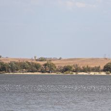
Lake Wabaunsee, body of water

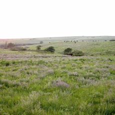
Lake Wabaunsee is a reservoir in Kansas near the town of Eskridge, fed by the waters of Mill Creek. The water spreads across a large area with open grasslands and tree clusters along the shoreline, while gentle hills shape the landscape.

The idea to create this reservoir began in 1928, with construction starting in 1933 supported by emergency programs during the Great Depression. The dam was completed on New Year's Eve in 1936, and the town of Eskridge later took control of the lake.

The lake carries the name of the Kaw Nation and reflects the region's connection to its natural surroundings. Today, families use the place for picnicking and relaxing, while anglers and boaters visit the waters regularly.

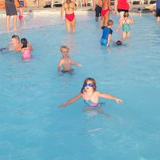
The lake is easily accessible with parking areas near the water and roads leading directly from nearby Eskridge. Activities such as fishing and boating require permits from the town office, and swimming is free for all visitors.

During World War II, the lake was used as a training camp for young men and later housed German prisoners of war who helped with local farm work. These prisoners never escaped and worked peacefully until the camp closed in 1945.

The community of curious travelers

AroundUs brings together thousands of curated places, local tips, and hidden gems, enriched daily by 60,000 contributors worldwide.

Start exploring
Location
GPS coordinates
38.86695,-96.19611
Latest update
February 9, 2026 07:47
Around this place
Cedar Crest
United States of America

Cedar Crest

44.8 km
Konza Prairie
United States of America

Konza Prairie

40.2 km
Beecher Bible and Rifle Church
United States of America

Beecher Bible and Rifle Church

33.5 km
Kansas Museum of History
United States of America

Kansas Museum of History

42.1 km
Council Grove Lake
United States of America

Council Grove Lake

33.7 km
United States of America

St. Mary's Mission

38 km
Oz Museum
United States of America

Oz Museum

38.5 km
Pottawatomie Indian Pay Station
United States of America

Pottawatomie Indian Pay Station

38 km
Last Chance Store
United States of America

Last Chance Store

34.3 km
Council Grove Historic District
United States of America

Council Grove Historic District

33.7 km
Security State Bank
United States of America

Security State Bank

7.7 km
First Baptist Church of Council Grove
United States of America

First Baptist Church of Council Grove

34.6 km
Pottawatomie Baptist Mission Building
United States of America

Pottawatomie Baptist Mission Building

42.1 km
Discovery Center of Kansas
United States of America

Discovery Center of Kansas

45 km
Big John Farm Limestone Bank Barn
United States of America

Big John Farm Limestone Bank Barn

31 km
Paxico Historic District
United States of America

Paxico Historic District

22.3 km
Alma Downtown Historic District
United States of America

Alma Downtown Historic District

18.2 km
Dunlap Colored Cemetery
United States of America

Dunlap Colored Cemetery

34 km
George and Virginia Trout House
United States of America

George and Virginia Trout House

38.8 km
Cassius & Adelia Baker House
United States of America

Cassius & Adelia Baker House

38.7 km
Greenwood Cemetery
United States of America

Greenwood Cemetery

35.2 km
Morris County Courthouse
United States of America

Morris County Courthouse

34.8 km
Council Grove Downtown Historic District
United States of America

Council Grove Downtown Historic District

34.4 km
Seth Hays House
United States of America

Seth Hays House

34.3 km
Midwest Health Aquatic Center
United States of America

Midwest Health Aquatic Center

40 km
Kaw Mission
United States of America

Kaw Mission

34.2 km
Stuewe House
United States of America

Stuewe House

18.5 km
Harris Bridge
United States of America

Harris Bridge

37.3 km
Show the full map
Reviews
Share your experience

No review yet

Discussions
Start a discussion...

No discussion yet

« Lake Wabaunsee - body of water » is provided by Around Us (aroundus.com). Images and texts are derived from Wikimedia project under a Creative Commons license. You are allowed to copy, distribute, and modify copies of this page, under the conditions set by the license, as long as this note is clearly visible.

Discover hidden gems everywhere you go!

From secret cafés to breathtaking viewpoints, skip the crowded tourist spots and find places that match your style. Our app makes it easy with voice search, smart filtering, route optimization, and insider tips from travelers worldwide. Download now for the complete mobile experience.

Around Us App Screenshot

A unique approach to discovering new places

Le Figaro

All the places worth exploring

France Info

A tailor-made excursion in just a few clicks

20 Minutes

Around Us
Travel Guide & Maps
Download

Send to your phone

QR Code
1

Open the camera app on your mobile.

2

Point at the QR code with your camera. A notification will appear.

3

Tap the notification to open the link.