Enable Location

We need your location to show you interesting places around you

Discover nearby places

Find interesting locations and hidden gems around you

Precise directions

Get accurate directions and distances to places

Your location is never shared with other users. It's only used when you tap the location button.

Log in to your account

Start exploring — it's free

Trusted by 63,307 travelers worldwide

Continue with Google
Continue with Apple
or

We will send you a code to connect

By continuing, you accept our Terms and Conditions and our Privacy Policy

Check your inbox

We've sent a pincode in your inbox. Please enter the code below.

Loyalhanna Lake
Discussion Reviews Photo
1.7k Popularity

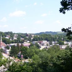
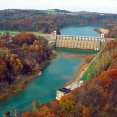
Loyalhanna Lake, River in Westmoreland, Pennsylvania

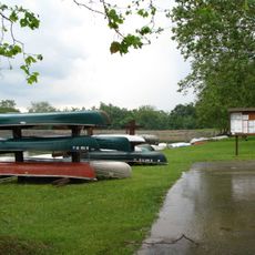
Loyalhanna Lake is a reservoir in Westmoreland County, Pennsylvania, created by damming a river to store water and manage flooding. The body of water is surrounded by trees and open spaces, with trails for walking and areas for boating, fishing, and picnicking along the shoreline.

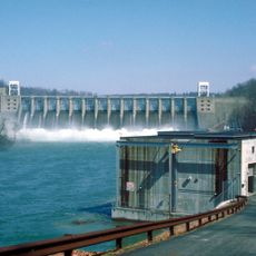
The lake was created several decades ago when a dam was built to improve water management and flood control in the region. The dam and reservoir have since become essential parts of local life and community infrastructure.

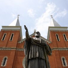
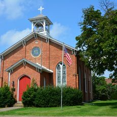
The name Loyalhanna comes from the river that once flowed through this area. Today, the lake is a place where people gather for fishing tournaments, picnics, and outdoor traditions that connect local residents to the water and each other.

The lake is easily reached by nearby roads and offers parking areas, picnic spots, and boat ramps for visitors. The flat trails along the shore are suitable for families and people of all ages, making a day visit straightforward and accessible.

The lake freezes over in winter, and its surface is sometimes used by people for ice skating, giving the place a different character during colder months. This seasonal transformation means each visit offers a different experience depending on when you arrive.

The community of curious travelers

AroundUs brings together thousands of curated places, local tips, and hidden gems, enriched daily by 60,000 contributors worldwide.

Start exploring
GPS coordinates
40.45667,-79.45167
Latest update
February 9, 2026 08:20
Around this place
Saint Vincent Archabbey
United States of America

Saint Vincent Archabbey

18.7 km
Keystone State Park
United States of America

Keystone State Park

11.1 km
Bushy Run Battlefield
United States of America

Bushy Run Battlefield

18.2 km
Conemaugh Dam
United States of America

Conemaugh Dam

7.4 km
Westmoreland County Courthouse
United States of America

Westmoreland County Courthouse

18.9 km
Greensburg Downtown Historic District
United States of America

Greensburg Downtown Historic District

18.8 km
Cathedral of the Blessed Sacrament
United States of America

Cathedral of the Blessed Sacrament

18.6 km
Five Star Trail
United States of America

Five Star Trail

17.8 km
Academy Hill Historic District
United States of America

Academy Hill Historic District

18.1 km
Site of Old Hannastown
United States of America

Site of Old Hannastown

13.4 km
Kingston House
United States of America

Kingston House

20.7 km
Drake Log Cabin
United States of America

Drake Log Cabin

16.7 km
St. Gertrude Roman Catholic Church
United States of America

St. Gertrude Roman Catholic Church

19 km
Citizens National Bank of Latrobe
United States of America

Citizens National Bank of Latrobe

16.6 km
St. Vincent Archabbey Gristmill
United States of America

St. Vincent Archabbey Gristmill

18.4 km
Brush Creek Salems Church
United States of America

Brush Creek Salems Church

23.3 km
St. Peter's Episcopal Church and Rectory
United States of America

St. Peter's Episcopal Church and Rectory

16.1 km
Vandergrift Historic District
United States of America

Vandergrift Historic District

18.7 km
John Walter Farmstead
United States of America

John Walter Farmstead

15.4 km
Saltsburg Historic District
United States of America

Saltsburg Historic District

3 km
Byerly House
United States of America

Byerly House

22.4 km
Salem Crossroads Historic District
United States of America

Salem Crossroads Historic District

11.1 km
Leechburg Bridge
United States of America

Leechburg Bridge

23 km
Hannastown Farm
United States of America

Hannastown Farm

12.4 km
Samuel Patterson House
United States of America

Samuel Patterson House

6.8 km
Slickville Historic District
United States of America

Slickville Historic District

6.1 km
Westmoreland Museum of American Art
United States of America

Westmoreland Museum of American Art

18.5 km
Conemaugh River Lake Dam
United States of America

Conemaugh River Lake Dam

8.5 km
Show the full map
Reviews
Share your experience

No review yet

Discussions
Start a discussion...

No discussion yet

« Loyalhanna Lake - River in Westmoreland, Pennsylvania » is provided by Around Us (aroundus.com). Images and texts are derived from Wikimedia project under a Creative Commons license. You are allowed to copy, distribute, and modify copies of this page, under the conditions set by the license, as long as this note is clearly visible.

Discover hidden gems everywhere you go!

From secret cafés to breathtaking viewpoints, skip the crowded tourist spots and find places that match your style. Our app makes it easy with voice search, smart filtering, route optimization, and insider tips from travelers worldwide. Download now for the complete mobile experience.

Around Us App Screenshot

A unique approach to discovering new places

Le Figaro

All the places worth exploring

France Info

A tailor-made excursion in just a few clicks

20 Minutes

Around Us
Travel Guide & Maps
Download

Send to your phone

QR Code
1

Open the camera app on your mobile.

2

Point at the QR code with your camera. A notification will appear.

3

Tap the notification to open the link.