Consuegra Dam, Roman dam in Consuegra, Spain.
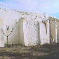
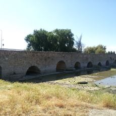
Consuegra Dam is a Roman structure built across the River Amarguillo with reinforced walls supported by additional buttresses along its length. The facility operated as a water storage system for the ancient settlement that once stood here.
The structure was built between the 3rd and 4th century AD to store water for the ancient city of Consabura. Its construction demonstrates that Romans had developed sophisticated water management techniques established in this region by that time.
The structure shows how Romans managed water resources for their settlements and applied their engineering knowledge across this region. Walking along it, you can observe the careful planning behind the construction and how water was controlled for practical use.
The site sits roughly one kilometer from the CM 4116 road between Consuegra and Urda, making it accessible from the main town. Walking from Consuegra center and following local paths leads you directly to the remains by the riverside.
The structure includes a domed corridor running perpendicular to the main wall that served as an overflow channel. This clever system reveals how Roman engineers thought through the problem of controlling excess water during floods.
Location: Consuegra
GPS coordinates: 39.42956,-3.65486
Latest update: December 14, 2025 14:44
Tablas de Daimiel National Park
31.9 km
Molinos de Consuegra
4.7 km
Castle of la Muela
4.8 km
Castillo de Guadalerzas, Los Yébenes
13.6 km
Castillo de Mora
28.9 km
Castle of Orgaz
30.9 km
Embalse de Finisterre
21.9 km
Church of Santo Tomás Apóstol
30.7 km
La Unión Windmill
17.3 km
Castle of Manzaneque
25.9 km
Casa de las Torres, Tembleque
32.1 km
Hermitage of the Santísimo Cristo of the Vera Cruz, Consuegra
5.2 km
Bullring of Madridejos
11.6 km
Church of Santa María la Mayor, Consuegra
5.5 km
Puente Romano, Villarta de San Juan
28.5 km
Iglesia de Santa Quiteria
24.5 km
Church of Santa María de la Asunción
19.4 km
Church of Arenas de San Juan
26.8 km
Biblioteca Pública Municipal de Puerto Lápice
19 km
Silo of Madridejos
12.1 km
Iglesia de Santa María la Real, Los Yébenes
25.1 km
Town Hall of Los Yébenes
25.1 km
Biblioteca Pública Municipal de Villarrubia de los Ojos - Francisco Gómez-Porro
23.9 km
Town Hall of Puerto Lápice
19 km
Silo de Turleque
20.2 km
Plaza de la Constitución, Los Yébenes
25.1 km
Biblioteca Pública Municipal de Mora
30.1 km
Rollo jurisdiccional de Madridejos
11.2 kmVisited this place? Tap the stars to rate it and share your experience / photos with the community! Try now! You can cancel it anytime.
Discover hidden gems everywhere you go!
From secret cafés to breathtaking viewpoints, skip the crowded tourist spots and find places that match your style. Our app makes it easy with voice search, smart filtering, route optimization, and insider tips from travelers worldwide. Download now for the complete mobile experience.
A unique approach to discovering new places❞
— Le Figaro
All the places worth exploring❞
— France Info
A tailor-made excursion in just a few clicks❞
— 20 Minutes