Church of All Saints, Sutton Bingham

Log in to your account

AroundUs is a community-driven map of interesting places, built by curious explorers like you. It grows with every review, story, and photo you share.
Connect to save your favorite spots, contribute locations, and create personalized routes.
By continuing, you accept our Terms and Conditions and our Privacy Policy

Church of All Saints, Sutton Bingham

Add to collection
Map
Suggest a change
Share

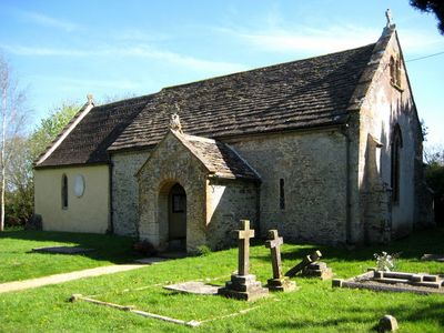
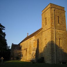
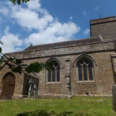
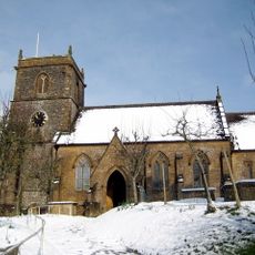
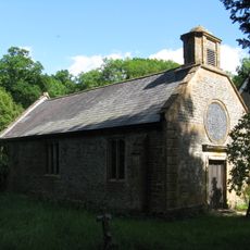
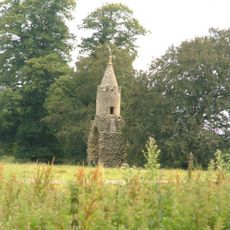
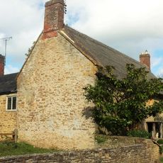
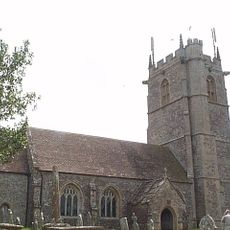
Church of All Saints, Sutton Bingham, Medieval church in Sutton Bingham, England

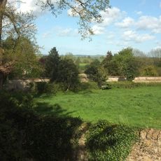
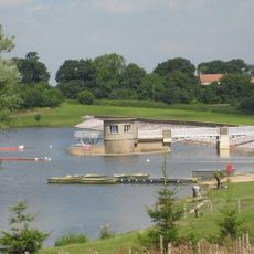
The Church of All Saints sits near the western shore of Sutton Bingham reservoir and features unrestored Norman architectural elements with medieval wall paintings throughout its interior. The building retains its original structure and ornamentation from different building periods that shape its appearance.

The building was constructed in the early 13th century and is registered as a Grade I listed structure. It houses two bells, with the older one dating to around 1250.

The interior walls display religious paintings from the 14th century showing the Coronation of the Virgin and depictions of bishops and saints. These images offer visitors a direct glimpse into medieval spiritual beliefs and artistic craft.

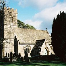
The building sits next to a reservoir in a quiet area, so visitors should bring sturdy footwear and allow time for a leisurely walk around the grounds. The church is best visited on clear days when light streams through the windows and interior details are visible.

A sundial from 1915 sits mounted on the south-west corner of the nave and still bears its original basic markings. This detail shows how visitors could once tell the time before modern clocks became widespread.

Location: Closworth

Inception: 13 century

GPS coordinates: 50.89750,-2.64361

Latest update: December 14, 2025 18:03

Photos
Around this place
Naish Priory
United Kingdom

Naish Priory

2.9 km
Yeovil Railway Centre
United Kingdom

Yeovil Railway Centre

3.7 km
Church of Saint Michael
United Kingdom

Church of Saint Michael

1.5 km
Coker Court
United Kingdom

Coker Court

1.5 km
Helyar Almshouses
United Kingdom

Helyar Almshouses

1.5 km
Church of Saint Roch
United Kingdom

Church of Saint Roch

2.8 km
Church of Saint Mary Magdalene
United Kingdom

Church of Saint Mary Magdalene

2.9 km
Church of Saint Mary
United Kingdom

Church of Saint Mary

3.7 km
Church of All Saints, Closworth
United Kingdom

Church of All Saints, Closworth

1.9 km
Parish Church of St James
United Kingdom

Parish Church of St James

3.7 km
Church of St Juthware and St Mary
United Kingdom

Church of St Juthware and St Mary

3 km
Parish Church of St Hypolite
United Kingdom

Parish Church of St Hypolite

3.4 km
Yeovil Railway Centre
United Kingdom

Yeovil Railway Centre

3.7 km
Helyar Arms Public House
United Kingdom

Helyar Arms Public House

1.4 km
Silverweed Cottage
United Kingdom

Silverweed Cottage

1.4 km
Needle Obelisk At Ngr St 559 129
United Kingdom

Needle Obelisk At Ngr St 559 129

2.2 km
Jack The Treacle Eater
United Kingdom

Jack The Treacle Eater

3.5 km
The Walls To The Kitchen Garden, Approximately 30 Metres North North West Of Coker Court
United Kingdom

The Walls To The Kitchen Garden, Approximately 30 Metres North North West Of Coker Court

1.5 km
Slade's Farm House
United Kingdom

Slade's Farm House

1.3 km
Milestone In Boundary Wall
United Kingdom

Milestone In Boundary Wall

3.7 km
Goodman Chest Tomb, In The Churchyard 1.5 Metres North Of The North Porch, Church Of Saint Michael
United Kingdom

Goodman Chest Tomb, In The Churchyard 1.5 Metres North Of The North Porch, Church Of Saint Michael

1.5 km
Barn, 50 Metres North Of Key Farm House
United Kingdom

Barn, 50 Metres North Of Key Farm House

2.5 km
Milestone, 83M South-West Of The Junction Between West Coker Road (A30) And Camp Road
United Kingdom

Milestone, 83M South-West Of The Junction Between West Coker Road (A30) And Camp Road

3.6 km
Signpost At Ngr 51871219
United Kingdom

Signpost At Ngr 51871219

3.1 km
Pavyotts Mill House
United Kingdom

Pavyotts Mill House

2.2 km
Milestone, Stoford village, opp. Garage
United Kingdom

Milestone, Stoford village, opp. Garage

3.1 km
Collins Chest Tomb, 2 Metres South Of The South East Nave Window, Church Of All Saints
United Kingdom

Collins Chest Tomb, 2 Metres South Of The South East Nave Window, Church Of All Saints

1.9 km
Sutton Bingham Reservoir
United Kingdom

Sutton Bingham Reservoir

118 m
Show the full map
Reviews

Visited this place? Tap the stars to rate it and share your experience / photos with the community! Try now! You can cancel it anytime.

« Church of All Saints, Sutton Bingham - Medieval church in Sutton Bingham, England » is provided by Around Us (aroundus.com). Images and texts are derived from Wikimedia project under a Creative Commons license. You are allowed to copy, distribute, and modify copies of this page, under the conditions set by the license, as long as this note is clearly visible.

Discover hidden gems everywhere you go!

From secret cafés to breathtaking viewpoints, skip the crowded tourist spots and find places that match your style. Our app makes it easy with voice search, smart filtering, route optimization, and insider tips from travelers worldwide. Download now for the complete mobile experience.

Around Us App Screenshot

A unique approach to discovering new places

Le Figaro

All the places worth exploring

France Info

A tailor-made excursion in just a few clicks

20 Minutes