Metchley Fort, Roman military fort in Birmingham, England
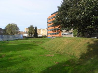
Metchley Fort is a Roman military fort near Birmingham with visible earthwork banks and ditches that outline the defensive structure of the ancient installation. The site preserves the rectangular plan and positioning of the original fortifications.
The fort was established in the mid-1st century as a control point during Rome's northward expansion across Britain. It was later abandoned, and the location saw different uses in subsequent periods.
The name comes from a nearby farmstead, and the site retains earthen banks that outline the fort's original footprint across the landscape. Walking through the grounds, one can sense the scale of the Roman military presence that once occupied this location.
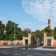
The site is freely accessible within a public park where visitors can walk among the earthworks and ditches at close range. Interpretation boards throughout the grounds explain the fort's layout and help orient visitors to the ancient features.
The fort underwent several rebuildings and later received horse stables and workshops before eventual abandonment. These changes show how military locations adapted to different needs over time.
Location: Birmingham
GPS coordinates: 52.45140,-1.93880
Latest update: December 9, 2025 18:46
Joseph Chamberlain Memorial Clock Tower
574 m
Barber Institute of Fine Arts
754 m
Winterbourne House and Garden
981 m
Lapworth Museum of Geology
518 m
Edgbaston Hall
1.7 km
St Peter's Church, Harborne
1.4 km
St Edward's Church, Selly Park, Birmingham
1.5 km
St Mary's Church
1.6 km
University House
946 m
Selly Oak Park
1.1 km
Selly Oak Pumping Station
828 m
Selly Oak Library
884 m
Selly Oak Elim Church
1.2 km
St Stephen's Church, Selly Park
1.4 km
Equestrian statue of George I
804 m
21 Yateley Road
1.4 km
Great Hall and Quadrant Range
598 m
King Edward's School Chapel
1.2 km
The White Swan Public House
1.7 km
Park Mount House
1.6 km
Berrow Court Hotel
1.7 km
Metchley Abbey
792 m
The Bell Public House
1.4 km
Garth House
853 m
Knutsford Lodge
896 m
641 And 659, Bristol Road B29
869 m
University of Birmingham Lodge, Gates, Gate Piers and Wall
875 m
Round & Parrott blue plaque
1.6 kmVisited this place? Tap the stars to rate it and share your experience / photos with the community! Try now! You can cancel it anytime.
Discover hidden gems everywhere you go!
From secret cafés to breathtaking viewpoints, skip the crowded tourist spots and find places that match your style. Our app makes it easy with voice search, smart filtering, route optimization, and insider tips from travelers worldwide. Download now for the complete mobile experience.
A unique approach to discovering new places❞
— Le Figaro
All the places worth exploring❞
— France Info
A tailor-made excursion in just a few clicks❞
— 20 Minutes