Enable Location

We need your location to show you interesting places around you

Discover nearby places

Find interesting locations and hidden gems around you

Precise directions

Get accurate directions and distances to places

Your location is never shared with other users. It's only used when you tap the location button.

White Cliffs of Dover

Log in to your account

Start exploring — it's free

Trusted by 62,169 travelers worldwide

Continue with Google
Continue with Apple
or

We will send you a code to connect

By continuing, you accept our Terms and Conditions and our Privacy Policy

Check your inbox

We've sent a pincode in your inbox. Please enter the code below.

White Cliffs of Dover

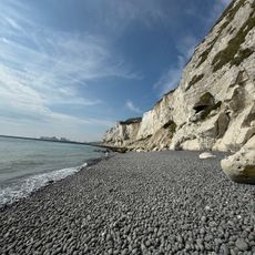
White Cliffs of Dover, Chalk cliffs in Dover, England.

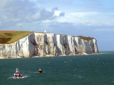
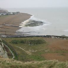
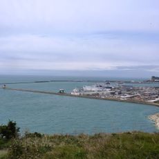
The White Cliffs of Dover are chalk formations along the English Channel that extend roughly 13 kilometers and rise in places up to 110 meters above the water. Their white surface shows distinct layers of chalk interspersed with dark flint bands that catch the sunlight and stand out clearly against the sea.

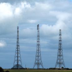
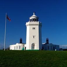
For centuries, these formations served as a navigation point for sailors crossing the channel and heading toward British ports. Their prominent position also helped warn ships of danger and played a role in various defense strategies over time.

For generations, these chalk formations have served as a recognizable emblem of the nation, appearing in songs, paintings, and written works. Many travelers visit because the cliffs hold a deep connection to the country's identity and continue to inspire artistic expression today.

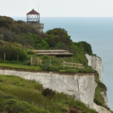
Several walking trails run along the top of the formations, allowing visitors to stroll with views over the water and, on clear days, toward the French coastline. Viewing platforms are set up at different points to make it easier to reach the best outlooks.

The cliff faces hold millions of fossils from the Cretaceous period, showing remains of tiny sea organisms and forming a natural archive of prehistoric life. Careful observers can spot small imprints and shell fragments directly in the chalk surface.

The community of curious travelers

AroundUs brings together thousands of curated places, local tips, and hidden gems, enriched daily by 60,000 contributors worldwide.

Start exploring
Location
GPS coordinates
51.13472,1.35711
Latest update
December 12, 2025 16:47
Coastal and mountain cliffs worldwide

Cliffs rank among Earth's most striking geological formations, ranging from coastal precipices to inland mountain faces. Along oceans, they shape coastlines for thousands of miles, while in mountain regions they form vertical walls that draw climbers from around the world. This collection documents...

Around this place
Fan Bay Deep Shelter
United Kingdom

Fan Bay Deep Shelter

319 m
Swingate transmitting station
United Kingdom

Swingate transmitting station

1.5 km
United Kingdom

South Foreland

1.2 km
Dover to Kingsdown Cliffs
United Kingdom

Dover to Kingsdown Cliffs

1.6 km
United Kingdom

St Margaret's Bay Windmill

1.6 km
South Foreland Upper Lighthouse
United Kingdom

South Foreland Upper Lighthouse

1.2 km
South Foreland Lower Lighthouse
United Kingdom

South Foreland Lower Lighthouse

1.5 km
Church of St Peter
United Kingdom

Church of St Peter

2.2 km
Swingate Inn
United Kingdom

Swingate Inn

2 km
Langdon Beach
United Kingdom

Langdon Beach

466 m
Royal Flying Corps Memorial, Dover
United Kingdom

Royal Flying Corps Memorial, Dover

1 km
Wallets Court
United Kingdom

Wallets Court

2.1 km
United Kingdom

Wanstone Farmhouse

1 km
United Kingdom

The Headmasters House

2.2 km
Bere Farmhouse
United Kingdom

Bere Farmhouse

1.6 km
United Kingdom

The Infirmary

2.2 km
Eastern Arm, Dover Harbour
United Kingdom

Eastern Arm, Dover Harbour

1.4 km
Milestone, Guston, E of tree screen to Duke of York's Royal Military School, quarter mile S of A2 jct
United Kingdom

Milestone, Guston, E of tree screen to Duke of York's Royal Military School, quarter mile S of A2 jct

2.1 km
United Kingdom

High Gaut

1.7 km
United Kingdom

A pair of acoustic mirrors at Fan Bay

304 m
United Kingdom

Buried Reserve And Pillbox, Former Swingate Chain Home Radar Station

1.5 km
United Kingdom

Receiver Site And Royal Observer Corps Underground Nuclear Monitoring Post, Former Swingate Chain Home Radar Station

1.2 km
United Kingdom

Transmitter Site (Excluding Tower 2), Former Swingate Chain Home Radar Station

1.5 km
United Kingdom

Fan Bay Sound Mirrors

300 m
United Kingdom

National Trust White Cliffs of Dover

1.4 km
United Kingdom

East Entrance Lodges Gates And Flanking Walls

2.2 km
United Kingdom

Scenic viewpoint

850 m
United Kingdom

Scenic viewpoint, bench

398 m
Show the full map
« White Cliffs of Dover - Chalk cliffs in Dover, England » is provided by Around Us (aroundus.com). Images and texts are derived from Wikimedia project under a Creative Commons license. You are allowed to copy, distribute, and modify copies of this page, under the conditions set by the license, as long as this note is clearly visible.

Discover hidden gems everywhere you go!

From secret cafés to breathtaking viewpoints, skip the crowded tourist spots and find places that match your style. Our app makes it easy with voice search, smart filtering, route optimization, and insider tips from travelers worldwide. Download now for the complete mobile experience.

Around Us App Screenshot

A unique approach to discovering new places

Le Figaro

All the places worth exploring

France Info

A tailor-made excursion in just a few clicks

20 Minutes

Around Us
Travel Guide & Maps
Download

Send to your phone

QR Code
1

Open the camera app on your mobile.

2

Point at the QR code with your camera. A notification will appear.

3

Tap the notification to open the link.