Enable Location

We need your location to show you interesting places around you

Discover nearby places

Find interesting locations and hidden gems around you

Precise directions

Get accurate directions and distances to places

Your location is never shared with other users. It's only used when you tap the location button.

Swingate transmitting station

Log in to your account

Start exploring — it's free

Trusted by 66,045 travelers worldwide

Continue with Google
Continue with Apple
or

We will send you a code to connect

By continuing, you accept our Terms and Conditions and our Privacy Policy

Check your inbox

We've sent a pincode in your inbox. Please enter the code below.

Discussion Reviews 1 Photos
3.1k Popularity

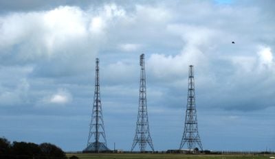
Swingate transmitting station, Transmitter station in St Margaret's at Cliffe, England.

Swingate transmitting station is a telecommunications facility near St Margaret's at Cliffe on the southeastern coast of Kent, made up of several tall masts and related structures spread across open land. The site holds Grade II* listed building status, which means it is recognized as having more than special interest at a national level.

The station was built during World War II as part of the Chain Home radar network, which was one of the first early warning radar systems used in combat. After the war ended, the site gradually shifted from military radar use to civilian telecommunications, and it has remained in operation ever since.

The name Swingate refers to the old local topography, and the towers visible from the surrounding farmland have become a familiar part of the landscape for people living along this stretch of the Kent coast. Walkers on the nearby coastal paths often spot the masts rising above the fields long before they reach the clifftop.

The site is an active facility and is not open to the public, so visits are limited to viewing from outside the perimeter. The coastal paths running nearby along the clifftops give a clear view of the masts without needing to approach the fenced areas.

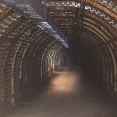
Below the visible masts, wartime bunkers were built underground to keep operations running even if the surface structures were hit. These underground spaces are not visible from the outside and are easy to miss when looking at what appears to be just a field of tall masts.

The community of curious travelers

AroundUs brings together thousands of curated places, local tips, and hidden gems, enriched daily by 60,000 contributors worldwide.

Start exploring
GPS coordinates
51.13780,1.33583
Latest update
March 3, 2026 13:54
Reviews
Share your experience

No review yet

Discussions
Start a discussion...

No discussion yet

« Swingate transmitting station - Transmitter station in St Margaret's at Cliffe, England » is provided by Around Us (aroundus.com). Images and texts are derived from Wikimedia project under a Creative Commons license. You are allowed to copy, distribute, and modify copies of this page, under the conditions set by the license, as long as this note is clearly visible.

Discover hidden gems everywhere you go!

From secret cafés to breathtaking viewpoints, skip the crowded tourist spots and find places that match your style. Our app makes it easy with voice search, smart filtering, route optimization, and insider tips from travelers worldwide. Download now for the complete mobile experience.

Around Us App Screenshot

A unique approach to discovering new places

Le Figaro

All the places worth exploring

France Info

A tailor-made excursion in just a few clicks

20 Minutes

Around Us
Travel Guide & Maps
Download

Send to your phone

QR Code
1

Open the camera app on your mobile.

2

Point at the QR code with your camera. A notification will appear.

3

Tap the notification to open the link.