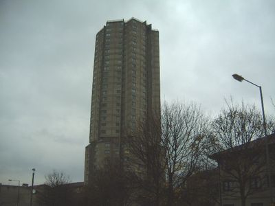
Derwent Tower, Brutalist high-rise building in Dunston, England
Derwent Tower is a concrete residential tower with a rectangular form designed by architect Owen Luder, rising 90 meters (295 feet) above the landscape. The building contains two-bedroom apartments on the lower floors and one-bedroom units on the upper floors, serving as housing for hundreds of residents.
Built in 1972, the tower emerged from a revised design plan that originally called for three towers with 22 stories each. The project was scaled back to a single structure due to changing economic and urban planning priorities.
Local residents gave the tower the nickname 'Dunston Rocket' because of its distinctive shape and towering presence. This name stuck in the community and shows how the building became part of local identity.
Access to the tower varies depending on the purpose of the visit, and visitors should check ahead about which areas are open to explore. The concrete exterior weathers noticeably over time, so visiting during good weather helps to see the building's form and character more clearly.
The tower appeared in a Tudor Crisps television advertisement during the 1970s, giving it unexpected moments in popular culture. This commercial appearance helped the building gain recognition beyond the local area.
Location: Dunston
Inception: 1972
Architects: Owen Luder
Architectural style: brutalism
GPS coordinates: 54.95210,-1.63944
Latest update: December 11, 2025 11:03
Turbinia
2.1 km
Discovery Museum
2.1 km
Centre for Life
2.1 km
Redheugh Bridge
1.7 km
King Edward VII Bridge
1.9 km
Queen Elizabeth II Metro Bridge
2.1 km
St Stephen's Church, Low Elswick
1.3 km
Dunston staiths
751 m
Tyne and Wear Archives Service
2.1 km
Church of St Chad
1.8 km
Church of St Michael And Presbytery Attached
1.5 km
Blandford House
2.1 km
Former Market Keeper's House
2.1 km
Water Tower South Of Central Station
2.2 km
Mather Tomb In St John's Cemetery
1.8 km
Grainger Memorial Fountain
2.2 km
11-33, Summerhill Street
2.2 km
River Tyne Dunston Coal Staithes
779 m
The Coach House
2.2 km
1 Neville Street
2.2 km
St Pauls Church Of England School (North Part)
2.1 km
St Anne's Convent And Walls Attached
2.1 km
Railings And Walls To South And East Of Hospital Of St Mary The Virgin Almshouses
1.9 km
1-10, Winchester Terrace
2.2 km
Steps And Railings To Right Of Number 2
2 km
Hospital Of St Mary The Virgin Almshouses
1.8 km
7-12, Summerhill Terrace
2.2 km
Bensham Bank, by park
1.5 kmVisited this place? Tap the stars to rate it and share your experience / photos with the community! Try now! You can cancel it anytime.
Discover hidden gems everywhere you go!
From secret cafés to breathtaking viewpoints, skip the crowded tourist spots and find places that match your style. Our app makes it easy with voice search, smart filtering, route optimization, and insider tips from travelers worldwide. Download now for the complete mobile experience.
A unique approach to discovering new places❞
— Le Figaro
All the places worth exploring❞
— France Info
A tailor-made excursion in just a few clicks❞
— 20 Minutes