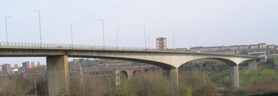
Redheugh Bridge, Road bridge between Newcastle upon Tyne and Gateshead, England.
Redheugh Bridge is a concrete road bridge spanning approximately 900 meters across the river with four traffic lanes for vehicles. The main central opening allows passage for river traffic below the deck.
The current structure opened in 1983 and replaced earlier bridges that had served the crossing since the 1870s but gradually developed structural issues. This replacement was a significant infrastructure renewal for the region at that time.
The bridge serves as a daily crossing for thousands of commuters moving between the two cities. It has become a familiar landmark in the everyday landscape of the region.
The bridge is accessible on foot and by bicycle with separate paths on both sides for different types of traffic. Walking across works best outside peak commuting hours when there is less vehicle movement.
The road deck is designed so the bridge appears to be the highest spanning the river even though no structural elements rise above the roadway. This creates a deceptively simple profile that sets it apart from other crossings in the area.
Location: Newcastle upon Tyne
Location: Gateshead
Inception: May 18, 1983
Official opening: May 18, 1983
Length: 897 m
Longest Span: 160 m
Width: 15.8 m
Made from material: concrete
GPS coordinates: 54.96200,-1.61900
Latest update: December 8, 2025 20:03
Centre for Life
620 m
St Mary's Cathedral, Newcastle upon Tyne
782 m
King Edward VII Bridge
223 m
Queen Elizabeth II Metro Bridge
429 m
Life Science Centre
568 m
Westgate House, Newcastle upon Tyne
820 m
Royal Station Hotel
832 m
The County Hotel
851 m
Gunner Tower
825 m
Grainger Memorial Fountain
790 m
Turnbull's Warehouse
828 m
Alfred Wilson House
837 m
Water Tower South Of Central Station
618 m
Former Market Keeper's House
635 m
Forth House
838 m
35, Close
816 m
Bonded Warehouses
602 m
26-36, Clayton Street West
805 m
Former coppersmiths shop and warehouses with offices attached
557 m
Clavering House
834 m
Bewick House
820 m
1 Neville Street
710 m
Motorail Terminal
720 m
Barclays Bank
768 m
Newcastle upon Tyne town defences: section of curtain wall and town ditch between Forth Street and Hanover Street
706 m
Town Wall North Of The Close And Breakneck Stairs
644 m
Presbytery Attached To Cathedral Of St Mary
771 m
Number 20 And Building To Rear (number 18 Now Demolished)
615 mVisited this place? Tap the stars to rate it and share your experience / photos with the community! Try now! You can cancel it anytime.
Discover hidden gems everywhere you go!
From secret cafés to breathtaking viewpoints, skip the crowded tourist spots and find places that match your style. Our app makes it easy with voice search, smart filtering, route optimization, and insider tips from travelers worldwide. Download now for the complete mobile experience.
A unique approach to discovering new places❞
— Le Figaro
All the places worth exploring❞
— France Info
A tailor-made excursion in just a few clicks❞
— 20 Minutes