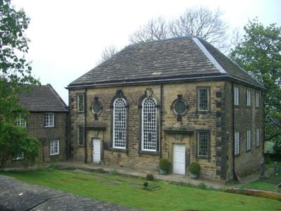
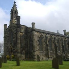
Underbank Chapel, Grade II listed church in Stannington, England
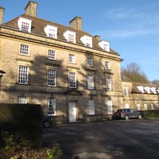
Underbank Chapel is a sandstone building on Stannington Road about 4 miles west of Sheffield, distinguished by tall round-headed windows and circular openings above its doors. The interior reflects its age and offers an authentic sense of a smaller religious gathering place.
The building was constructed between 1742 and 1743 after an older chapel from 1652 had become unfit for use. In the 1780s the congregation shifted toward Unitarianism, a theological direction that departed from traditional doctrine.
The chapel has long served as a gathering place for those with independent-minded beliefs and shapes community life in Bradfield. Visitors can experience the sense of belonging that brings people together here regularly.
The building is open for regular services and community events and is maintained by the congregation. Visitors should check ahead before visiting to ensure an event is happening or arrange access in advance.
The poet Samuel Taylor Coleridge visited in 1796 and met with Reverend Astley Meanley to discuss the possibility of embracing Unitarianism. This encounter shows the chapel was a place where significant intellectual questions were debated at the time.
Location: Bradfield
GPS coordinates: 53.39410,-1.55603
Latest update: December 14, 2025 16:44
Sandygate Road
2.6 km
Loxley House
2.6 km
Revell Grange
1 km
The Towers
2.4 km
Little Matlock Rolling Mill
1.5 km
Loxley United Reformed Church
1.6 km
Christ Church
643 m
Carsick Hall
2.6 km
Fox Hagg
2.6 km
Stannington War Memorial
556 m
Rivelin Valley Chair
2.2 km
St Michaels Cemetery Chapel
2.6 km
Monument And Railings To Gh Foster 7 Metres West Of St Michaels Cemetery Chapel
2.6 km
Cemetery Chapel At Crookes Cemetery
2.8 km
Walsh Monument And Railing At Rivelin Glen Cemetery
2.6 km
Hollins Bridge
2.6 km
The Lodge to Towers
2.5 km
Packhorse Bridge 70 metres east of Rails Road Bridge
1.5 km
Packhorse Bridge Over River Loxley At Croft House
905 m
Well House
673 m
The Barncliff Stoop
2.2 km
Spout House
379 m
Stannington Cross At Junction With Stannington Road On West Side Of Junction
1.6 km
White House Farmhouse
690 m
Rivelin Valley Road - Rails Road
1.5 km
Milestone, Manchester Road, 0.2 mile W of Bell Hagg PH(closed)
1.8 km
Milestone, between waterworks & Rivelin Dams
2.5 km
King Edward VII Orthopaedic Hospital, Sheffield
1.2 kmVisited this place? Tap the stars to rate it and share your experience / photos with the community! Try now! You can cancel it anytime.
Discover hidden gems everywhere you go!
From secret cafés to breathtaking viewpoints, skip the crowded tourist spots and find places that match your style. Our app makes it easy with voice search, smart filtering, route optimization, and insider tips from travelers worldwide. Download now for the complete mobile experience.
A unique approach to discovering new places❞
— Le Figaro
All the places worth exploring❞
— France Info
A tailor-made excursion in just a few clicks❞
— 20 Minutes