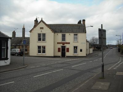
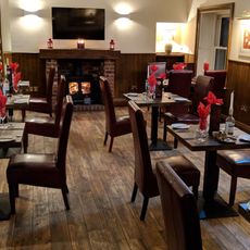
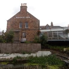
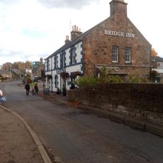
Newbridge Inn, Historic inn in Newbridge, Scotland
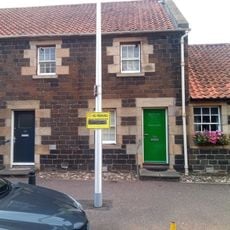
Newbridge Inn stands at the corner of Old Liston Road and Bridge Street, displaying traditional Scottish architecture dating from 1895. The building holds Category C listed status and the premises are no longer in operation as a public house.
The inn was established in 1683 on land owned by Archibald Hope of Raukellour and became an important stop for travelers. It stood along the principal route connecting Edinburgh and Glasgow throughout its long history.
The inn served as a vital gathering spot where the Newbridge community came together for social occasions and daily interaction. Its closure in 2023 left a noticeable gap in the local social fabric.
The building is no longer open to the public as it no longer operates as an inn. Visitors can view the exterior and architectural details from the street.
The original lease agreement from 1700 included an unusual payment arrangement where the tenant had to provide two lambs at Whitsunday and Christmas along with six hens at Whitsunday each year. Such payment in goods was a common feature of rural property agreements in that era.
Location: City of Edinburgh
Location: Edinburgh
GPS coordinates: 55.93933,-3.40816
Latest update: December 14, 2025 16:47
Dundas Castle
4 km
Jupiter Artland
3.7 km
Niddry Castle
3.1 km
Bonnington House
3.7 km
Hatton House
4.1 km
Cat Stane
3.2 km
Newliston
1.3 km
Almond Aqueduct
2.7 km
Newbridge chariot
352 m
Illieston Castle
3.4 km
Conifox
1.6 km
Huly Hill, cairn & stone circle SW of Newbridge roundabout
223 m
Bonnington Aqueduct
1.7 km
Almond Valley Viaduct
1 km
Broxburn Viaduct
1.6 km
Birdsmill railway bridge
2.1 km
Kirkliston, The Square, Kirkliston Parish Church
1.7 km
Catstane, inscribed stone and long cist cemetery 690m E of Carlowrie
3.2 km
Bridge No. 30, Niddry, Union Canal
3.1 km
Tormain Hill,cup & ring marked rocks 700m NE of Bonnington Mains
3.1 km
54 Main Street, Ratho
2.6 km
Bridge Inn, 27 Baird Road, Ratho, Union Canal
2.6 km
Lochend Farm, standing stone 100m WNW of
525 m
Dundas Castle, Dundas Loch Bridge
3.1 km
Depot And Bridge No. 23, Drumshoreland, Union Canal
4 km
Union Canal, Ratho, Baird Road, Bridge No. 15
2.5 km
Easter Norton,standing stone 280m WSW of
3.4 km
Ratho, Baird Road, Ratho Parish Church And Lady's Well
2.4 kmVisited this place? Tap the stars to rate it and share your experience / photos with the community! Try now! You can cancel it anytime.
Discover hidden gems everywhere you go!
From secret cafés to breathtaking viewpoints, skip the crowded tourist spots and find places that match your style. Our app makes it easy with voice search, smart filtering, route optimization, and insider tips from travelers worldwide. Download now for the complete mobile experience.
A unique approach to discovering new places❞
— Le Figaro
All the places worth exploring❞
— France Info
A tailor-made excursion in just a few clicks❞
— 20 Minutes