County Line Bowstring

Log in to your account

AroundUs is a community-driven map of interesting places, built by curious explorers like you. It grows with every review, story, and photo you share.
Connect to save your favorite spots, contribute locations, and create personalized routes.
Continue with Google
Continue with Apple
Continue with X
Continue with Facebook
Continue with email
By continuing, you accept our Terms and Conditions and our Privacy Policy
Create an account
Add to collection
Map
Suggest a change
Share

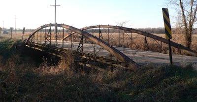
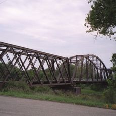
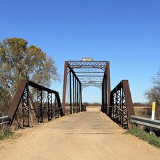
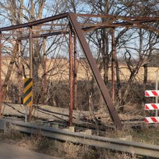
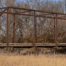
County Line Bowstring, Metal road bridge in Cloud and Republic Counties, Kansas.

County Line Bowstring is a metal road bridge spanning West Creek with a bowstring truss design and wooden deck. The structure measures approximately 80 feet (24 meters) long and 16 feet (5 meters) wide, connecting areas along the border between Cloud and Republic Counties.

This bridge was built in 1876 by the Wrought Iron Bridge Company of Ohio and was originally one of four spans in the Concordia bridge system. The structure survived over time and remained in place while other parts of the original system were removed or altered.

This bridge emerged during a period of rapid infrastructure expansion across rural Kansas, when metal spans connected farming communities separated by water. It became part of the everyday landscape for residents who relied on it to access their lands and maintain local connections.

The bridge is accessible via a county maintenance road and accommodates single-lane automobile traffic for visitors exploring the area. Those approaching should keep in mind this is a functioning infrastructure piece and treat it with appropriate care during any visit.

The structure preserves its original bowstring truss design from the late 1800s, representing a relatively uncommon engineering approach in the region today. This bridge type was innovative for its time and allowed engineers to span water obstacles efficiently before being superseded by later construction methods.

Location: Cloud County

Location: Republic County

Inception: 1876

Made from material: metal

GPS coordinates: 39.65389,-97.57306

Latest update: December 14, 2025 18:09

Photos
Around this place
Rock City, Kansas
United States of America

Rock City, Kansas

64.2 km
Nazareth Convent and Academy
United States of America

Nazareth Convent and Academy

12.5 km
Brown Grand Theatre
United States of America

Brown Grand Theatre

12 km
Site No. JF00-072
United States of America

Site No. JF00-072

42.5 km
Pawnee Indian Museum State Historic Site
United States of America

Pawnee Indian Museum State Historic Site

37.5 km
St. John the Baptist Catholic Church
United States of America

St. John the Baptist Catholic Church

50.4 km
Republican River Pegram Truss
United States of America

Republican River Pegram Truss

6.4 km
Wallace Warren and Lillian Genevieve Bradshaw Kendall House
United States of America

Wallace Warren and Lillian Genevieve Bradshaw Kendall House

58.9 km
Charles W. Van De Mark House
United States of America

Charles W. Van De Mark House

16.4 km
Pott's Ford Bridge
United States of America

Pott's Ford Bridge

41.5 km
Jamestown (Kansas) Wildlife Area
United States of America

Jamestown (Kansas) Wildlife Area

28.6 km
Bankers Loan and Trust Company Building
United States of America

Bankers Loan and Trust Company Building

11.7 km
Jewell County Courthouse
United States of America

Jewell County Courthouse

56.6 km
Cloud County Courthouse
United States of America

Cloud County Courthouse

12 km
Cloud County Veterans Memorial
United States of America

Cloud County Veterans Memorial

12.1 km
Clay County Courthouse
United States of America

Clay County Courthouse

49.3 km
Mitchell County Courthouse
United States of America

Mitchell County Courthouse

50.8 km
Glasco Downtown Historic District
United States of America

Glasco Downtown Historic District

39.8 km
Clay Center Carnegie Library
United States of America

Clay Center Carnegie Library

49.4 km
IOOF Temple Building
United States of America

IOOF Temple Building

63.4 km
Washington County Courthouse
United States of America

Washington County Courthouse

48.3 km
Jefferson County Courthouse
United States of America

Jefferson County Courthouse

63.2 km
Republic County Courthouse
United States of America

Republic County Courthouse

19.5 km
Fairbury Public Library
United States of America

Fairbury Public Library

63.6 km
Pawnee Indian Museum State Historic Site
United States of America

Pawnee Indian Museum State Historic Site

37.5 km
Bonham Theatre
United States of America

Bonham Theatre

63.3 km
Riley Creek Bridge
United States of America

Riley Creek Bridge

15.8 km
Queen Road-East Riley Creek Bridge
United States of America

Queen Road-East Riley Creek Bridge

15.2 km
Show the full map
Reviews

Visited this place? Tap the stars to rate it and share your experience / photos with the community! Try now! You can cancel it anytime.

« County Line Bowstring - Metal road bridge in Cloud and Republic Counties, Kansas » is provided by Around Us (aroundus.com). Images and texts are derived from Wikimedia project under a Creative Commons license. You are allowed to copy, distribute, and modify copies of this page, under the conditions set by the license, as long as this note is clearly visible.

Discover hidden gems everywhere you go!

From secret cafés to breathtaking viewpoints, skip the crowded tourist spots and find places that match your style. Our app makes it easy with voice search, smart filtering, route optimization, and insider tips from travelers worldwide. Download now for the complete mobile experience.

Around Us App Screenshot

A unique approach to discovering new places

Le Figaro

All the places worth exploring

France Info

A tailor-made excursion in just a few clicks

20 Minutes