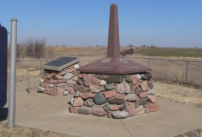
Site No. JF00-072, Survey marker at Kansas-Nebraska border intersection, United States.
Site No. JF00-072 is a stone monument at the Kansas-Nebraska border where counties Republic and Washington in Kansas meet counties Jefferson and Thayer in Nebraska. The site contains a disc marker with witness posts that indicate the survey line.
Deputy Surveyor Charles A. Manners established this sandstone monument in 1856 to define boundaries for land ownership in Kansas and Nebraska. The original monument was buried multiple times under roadbeds before its final excavation in 1986.
The monument served as a key reference point for surveying the American West during the settlement era. It helped surveyors establish boundaries for land ownership and territorial administration.
The monument is located at coordinates 40.0019 latitude and -97.3692 longitude at the state border. The site is accessible by car, but you should check if access across private land is required since the area is rural and sparsely populated.
The original sandstone monument was about 6 feet tall, but its middle section is now missing. Repeated burials under roadbeds over the decades left deep marks on the structure, and the 1986 excavation could only recover part of the monument.
The community of curious travelers
AroundUs brings together thousands of curated places, local tips, and hidden gems, enriched daily by 60,000 contributors worldwide.