Chest opened
+${chestReward.xp} XP
Explorer
NOUVEAU ×${chestReward.collectible.quantity}
tapez pour fermer
Chest locked

Open chests in the app

Around Us is built for your phone — chests unlock when you walk, explore and capture nearby places.

Enable Location

We need your location to show you interesting places around you

Discover nearby places

Find interesting locations and hidden gems around you

Precise directions

Get accurate directions and distances to places

Your location is never shared with other users. It's only used when you tap the location button.

Log in to your account

Start exploring — it's free

Trusted by 73,028 travelers worldwide

Continue with Google
Continue with Apple
or

We will send you a code to connect

By continuing, you accept our Terms and Conditions and our Privacy Policy

Check your inbox

We've sent a pincode in your inbox. Please enter the code below.

George N. Wade Memorial Bridge
Discussion Reviews Photo
1.9k Popularity

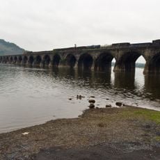
George N. Wade Memorial Bridge, Road bridge in Harrisburg, United States.

The George N. Wade Memorial Bridge is a road bridge spanning the Susquehanna River in Harrisburg that connects East Pennsboro Township with the downtown area. The structure includes six main traffic lanes plus collector roads with multiple ramp connections serving the highway network.

The bridge opened in 1970 and was named after George N. Wade, a Pennsylvania State Senator who served from 1941 until his death in 1974. It represented a major infrastructure project to improve transportation connections in the state capital region.

The structure represents Pennsylvania's commitment to infrastructure development, connecting communities across the Susquehanna River in the state capital region.

This bridge is part of Interstate 81 and carries thousands of vehicles daily moving between regions to the north and south. Traffic can be heavy during peak hours, so patience is advisable when crossing.

The bridge width varies between about 110 feet (33 meters) and 230 feet (70 meters) to accommodate different traffic lanes and collector roads with varying sizes. This unusual shape allows it to handle the complex highway traffic flow efficiently.

The community of curious travelers

AroundUs brings together thousands of curated places, local tips, and hidden gems, enriched daily by 60,000 contributors worldwide.

Start exploring
Location
Official opening
1970
GPS coordinates
40.31380,-76.90810
Latest update
December 14, 2025 11:44
Around this place
Keystone Corridor
United States of America

Keystone Corridor

5 km
Pennsylvania Governor's Residence
United States of America

Pennsylvania Governor's Residence

4.1 km
Rockville Bridge
United States of America

Rockville Bridge

2.2 km
United States of America

Capital Area Greenbelt

4.6 km
Susquehanna Art Museum
United States of America

Susquehanna Art Museum

5 km
Zembo Shrine Building
United States of America

Zembo Shrine Building

2.7 km
Harrisburg Military Post
United States of America

Harrisburg Military Post

4.8 km
Wildwood Park
United States of America

Wildwood Park

2 km
Kesher Israel Congregation
United States of America

Kesher Israel Congregation

3.2 km
Archibald McAllister House
United States of America

Archibald McAllister House

3.2 km
Dauphin County Veteran's Memorial Obelisk
United States of America

Dauphin County Veteran's Memorial Obelisk

2.6 km
Pennsylvania National Fire Museum
United States of America

Pennsylvania National Fire Museum

4.4 km
Old Uptown Historic District
United States of America

Old Uptown Historic District

4.6 km
Camp Curtin Fire Station
United States of America

Camp Curtin Fire Station

3.2 km
Sheffield Apartments
United States of America

Sheffield Apartments

4.2 km
Wesley Union African Methodist Episcopal Zion Church
United States of America

Wesley Union African Methodist Episcopal Zion Church

3.7 km
Fort Hunter Historic District
United States of America

Fort Hunter Historic District

3.1 km
Simon Cameron School
United States of America

Simon Cameron School

4.4 km
William Donaldson House
United States of America

William Donaldson House

4.1 km
Everhart Bridge
United States of America

Everhart Bridge

3.3 km
Harrisburg State Hospital
United States of America

Harrisburg State Hospital

4.5 km
Polyclinic Medical Center
United States of America

Polyclinic Medical Center

3 km

Harrisburg Improv Theatre

4.7 km
United States of America

Krevsky Center

1.8 km
United States of America

Circle of Peace

4.7 km
United States of America

Dance of Eternal Spring

2.4 km
United States of America

Andrew Curtin statue

3.8 km
United States of America

Work of art, mural

4.9 km
Show the full map
Reviews
Share your experience

No review yet

Discussions
Start a discussion...

No discussion yet

« George N. Wade Memorial Bridge - Road bridge in Harrisburg, United States » is provided by Around Us (aroundus.com). Images and texts are derived from Wikimedia project under a Creative Commons license. You are allowed to copy, distribute, and modify copies of this page, under the conditions set by the license, as long as this note is clearly visible.

Discover hidden gems everywhere you go!

From secret cafés to breathtaking viewpoints, skip the crowded tourist spots and find places that match your style. Our app makes it easy with voice search, smart filtering, route optimization, and insider tips from travelers worldwide. Download now for the complete mobile experience.

Around Us App Screenshot

A unique approach to discovering new places

Le Figaro

All the places worth exploring

France Info

A tailor-made excursion in just a few clicks

20 Minutes

Around Us
Travel Guide & Maps
Download

Send to your phone

QR Code
1

Open the camera app on your mobile.

2

Point at the QR code with your camera. A notification will appear.

3

Tap the notification to open the link.