Enable Location

We need your location to show you interesting places around you

Discover nearby places

Find interesting locations and hidden gems around you

Precise directions

Get accurate directions and distances to places

Your location is never shared with other users. It's only used when you tap the location button.

Gottlieb Brown Covered Bridge

Log in to your account

Start exploring — it's free

Trusted by 63,300 travelers worldwide

Continue with Google
Continue with Apple
or

We will send you a code to connect

By continuing, you accept our Terms and Conditions and our Privacy Policy

Check your inbox

We've sent a pincode in your inbox. Please enter the code below.

Discussion Reviews 1 Photos
1.2k Popularity

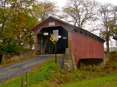
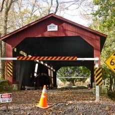
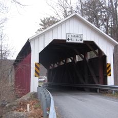
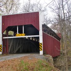
Gottlieb Brown Covered Bridge, Historic covered bridge in Columbia County, United States.

The Gottlieb Brown Covered Bridge is a wooden structure that crosses Chillisquaque Creek using a Burr Truss design to support its enclosed passage. The bridge connects two rural townships and represents the type of timber construction that once served as essential crossings throughout the region.

Built in 1881, the bridge demonstrates the evolution of bridge construction in 19th-century Pennsylvania. It received recognition on the National Register of Historic Places, acknowledging its standing as an important structure from that period.

The structure represents a prime example of 19th-century American bridge engineering, demonstrating the technical capabilities of Pennsylvania builders during the industrial era.

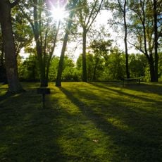
The bridge sits in a rural setting and can be viewed from the road that crosses it. Access is generally open, though visiting during quieter times of day helps with photography and observation without traffic interference.

The structure is also known locally as Sam Wagner Covered Bridge, a name that reflects connections to people from the area's past. Many visitors overlook this alternate designation despite its roots in the region's community history.

The community of curious travelers

AroundUs brings together thousands of curated places, local tips, and hidden gems, enriched daily by 60,000 contributors worldwide.

Start exploring
Location
GPS coordinates
41.00167,-76.77389
Latest update
December 14, 2025 18:45
Around this place
Joseph Priestley House
United States of America

Joseph Priestley House

12.5 km
Christy Mathewson–Memorial Stadium
United States of America

Christy Mathewson–Memorial Stadium

10.8 km
Shikellamy State Park
United States of America

Shikellamy State Park

13.7 km
Sojka Pavilion
United States of America

Sojka Pavilion

10.7 km
Milton State Park
United States of America

Milton State Park

7.7 km
Lewisburg Historic District
United States of America

Lewisburg Historic District

10.2 km
Sodom Schoolhouse
United States of America

Sodom Schoolhouse

6 km
Priestley-Forsyth Memorial Library
United States of America

Priestley-Forsyth Memorial Library

12.7 km
Rishel Covered Bridge
United States of America

Rishel Covered Bridge

5.8 km
Watsontown River Bridge
United States of America

Watsontown River Bridge

11.7 km
Slifer House
United States of America

Slifer House

9.6 km
Factory Bridge
United States of America

Factory Bridge

13.5 km
General William Montgomery House
United States of America

General William Montgomery House

13.8 km
Northumberland County Historical Society
United States of America

Northumberland County Historical Society

14.1 km
Danville Historic District
United States of America

Danville Historic District

13.9 km
Northumberland Historic District
United States of America

Northumberland Historic District

12.5 km
William Kirk House
United States of America

William Kirk House

11.3 km
Warrior Run Presbyterian Church
United States of America

Warrior Run Presbyterian Church

11.1 km
Danville West Market Street Historic District
United States of America

Danville West Market Street Historic District

13.3 km
Keefer Covered Bridge No. 7
United States of America

Keefer Covered Bridge No. 7

7.7 km
Milton Historic District
United States of America

Milton Historic District

6.8 km
Col. James Cameron House
United States of America

Col. James Cameron House

7.4 km
Hower-Slote House
United States of America

Hower-Slote House

11.3 km
Milton Armory
United States of America

Milton Armory

6.6 km
Hopper-Snyder Homestead
United States of America

Hopper-Snyder Homestead

12.4 km
Lewisburg Children's Museum
United States of America

Lewisburg Children's Museum

10.9 km
Campus Theatre
United States of America

Campus Theatre

10.4 km
St. Josephs Roman Catholic Church, Milton, PA
United States of America

St. Josephs Roman Catholic Church, Milton, PA

6.8 km
Show the full map
Reviews
Share your experience

No review yet

Discussions
Start a discussion...

No discussion yet

« Gottlieb Brown Covered Bridge - Historic covered bridge in Columbia County, United States » is provided by Around Us (aroundus.com). Images and texts are derived from Wikimedia project under a Creative Commons license. You are allowed to copy, distribute, and modify copies of this page, under the conditions set by the license, as long as this note is clearly visible.

Discover hidden gems everywhere you go!

From secret cafés to breathtaking viewpoints, skip the crowded tourist spots and find places that match your style. Our app makes it easy with voice search, smart filtering, route optimization, and insider tips from travelers worldwide. Download now for the complete mobile experience.

Around Us App Screenshot

A unique approach to discovering new places

Le Figaro

All the places worth exploring

France Info

A tailor-made excursion in just a few clicks

20 Minutes

Around Us
Travel Guide & Maps
Download

Send to your phone

QR Code
1

Open the camera app on your mobile.

2

Point at the QR code with your camera. A notification will appear.

3

Tap the notification to open the link.