Enable Location

We need your location to show you interesting places around you

Discover nearby places

Find interesting locations and hidden gems around you

Precise directions

Get accurate directions and distances to places

Your location is never shared with other users. It's only used when you tap the location button.

Watsontown River Bridge

Log in to your account

Start exploring — it's free

Trusted by 63,306 travelers worldwide

Continue with Google
Continue with Apple
or

We will send you a code to connect

By continuing, you accept our Terms and Conditions and our Privacy Policy

Check your inbox

We've sent a pincode in your inbox. Please enter the code below.

Discussion Reviews 1 Photos
1.1k Popularity

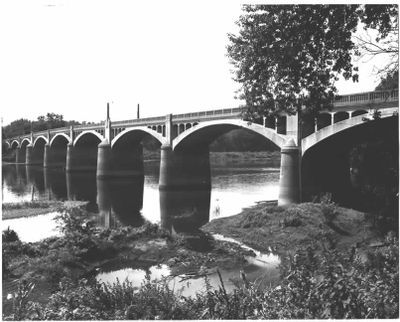
Watsontown River Bridge, bridge in Watsontown, Pennsylvania

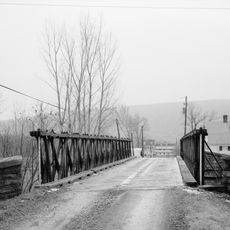
The Watsontown River Bridge is a concrete bridge built in 1927 that crosses the Susquehanna River, connecting two counties. It features nine open arch sections visible beneath the deck that provide structural support.

The bridge was designed by architect James B. Long and built by George W. Rockwell in 1927 to improve traffic between Watsontown and White Deer Township. In the 1980s, it gained recognition as a place on the National Register of Historic Places.

The bridge takes its name from the nearby town of Watsontown and links two communities across the river. It serves as a landmark that has brought generations together and shapes local identity.

The bridge is accessible to both pedestrians and vehicles, offering wide views of the river and surrounding countryside. Visitors should account for weather, as the surface can become slippery when wet.

The bridge's open-spandrel design was an innovative solution when completed, giving boats more clearance to pass underneath. Boaters and paddlers today still appreciate passing beneath the grand arch spans.

The community of curious travelers

AroundUs brings together thousands of curated places, local tips, and hidden gems, enriched daily by 60,000 contributors worldwide.

Start exploring
Location
GPS coordinates
41.08083,-76.86528
Latest update
February 9, 2026 07:42
Around this place
Tiadaghton State Forest
United States of America

Tiadaghton State Forest

17.1 km
Christy Mathewson–Memorial Stadium
United States of America

Christy Mathewson–Memorial Stadium

14.4 km
Muncy Creek
United States of America

Muncy Creek

15.3 km
Sojka Pavilion
United States of America

Sojka Pavilion

13.9 km
Lake Chillisquaque
United States of America

Lake Chillisquaque

17.4 km
Milton State Park
United States of America

Milton State Park

6.7 km
Lewisburg Historic District
United States of America

Lewisburg Historic District

13.1 km
Sodom Schoolhouse
United States of America

Sodom Schoolhouse

13.2 km
St. James Episcopal Church
United States of America

St. James Episcopal Church

15 km
Allenwood River Bridge
United States of America

Allenwood River Bridge

3.7 km
Gottlieb Brown Covered Bridge
United States of America

Gottlieb Brown Covered Bridge

11.7 km
Rishel Covered Bridge
United States of America

Rishel Covered Bridge

14 km
Slifer House
United States of America

Slifer House

11.8 km
Factory Bridge
United States of America

Factory Bridge

3.3 km
William Kirk House
United States of America

William Kirk House

4.9 km
Buffalo Presbyterian Church
United States of America

Buffalo Presbyterian Church

15.7 km
Muncy Historic District
United States of America

Muncy Historic District

15.2 km
Warrior Run Presbyterian Church
United States of America

Warrior Run Presbyterian Church

5.3 km
Keefer Covered Bridge No. 7
United States of America

Keefer Covered Bridge No. 7

15.5 km
Reading-Halls Station Bridge
United States of America

Reading-Halls Station Bridge

17.5 km
Milton Historic District
United States of America

Milton Historic District

6.7 km
Col. James Cameron House
United States of America

Col. James Cameron House

8.8 km
Hower-Slote House
United States of America

Hower-Slote House

6.3 km
Milton Armory
United States of America

Milton Armory

7.2 km
Hopper-Snyder Homestead
United States of America

Hopper-Snyder Homestead

1.7 km
Benjamin Griffey House
United States of America

Benjamin Griffey House

9.6 km
Lewisburg Children's Museum
United States of America

Lewisburg Children's Museum

13.6 km
Campus Theatre
United States of America

Campus Theatre

13.2 km
Show the full map
Reviews
Share your experience

No review yet

Discussions
Start a discussion...

No discussion yet

« Watsontown River Bridge - bridge in Watsontown, Pennsylvania » is provided by Around Us (aroundus.com). Images and texts are derived from Wikimedia project under a Creative Commons license. You are allowed to copy, distribute, and modify copies of this page, under the conditions set by the license, as long as this note is clearly visible.

Discover hidden gems everywhere you go!

From secret cafés to breathtaking viewpoints, skip the crowded tourist spots and find places that match your style. Our app makes it easy with voice search, smart filtering, route optimization, and insider tips from travelers worldwide. Download now for the complete mobile experience.

Around Us App Screenshot

A unique approach to discovering new places

Le Figaro

All the places worth exploring

France Info

A tailor-made excursion in just a few clicks

20 Minutes

Around Us
Travel Guide & Maps
Download

Send to your phone

QR Code
1

Open the camera app on your mobile.

2

Point at the QR code with your camera. A notification will appear.

3

Tap the notification to open the link.