Enable Location

We need your location to show you interesting places around you

Discover nearby places

Find interesting locations and hidden gems around you

Precise directions

Get accurate directions and distances to places

Your location is never shared with other users. It's only used when you tap the location button.

Harra Covered Bridge

Log in to your account

Start exploring — it's free

Trusted by 62,518 travelers worldwide

Continue with Google
Continue with Apple
or

We will send you a code to connect

By continuing, you accept our Terms and Conditions and our Privacy Policy

Check your inbox

We've sent a pincode in your inbox. Please enter the code below.

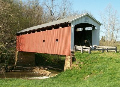
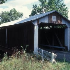
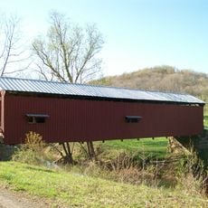
Harra Covered Bridge, Historic wooden bridge in Washington County, United States.

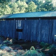
The Harra Covered Bridge is a historic wooden structure that crosses the South Branch of Wolf Creek in a rural area. It has vertical wooden walls and a metal roof covering the bridge span.

William Meredith built this bridge in 1875 using stones from a quarry on James Harrah's property. The structure represents a Long truss design that was popular in America during that era.

The bridge reflects building practices from the 1800s and draws visitors interested in learning how people engineered structures in rural America. Its construction shows methods that were common in the region and have largely disappeared.

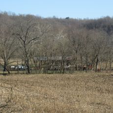
The bridge sits near State Route 339 and Township Road 172, making it accessible from nearby roads. Plan for uneven ground around the structure and allow time for walking and photography.

The name comes from James Harrah, who owned the farm where stones were quarried, but the final letter was dropped when officials recorded it. This minor spelling change in the official record has stuck for over a century.

The community of curious travelers

AroundUs brings together thousands of curated places, local tips, and hidden gems, enriched daily by 60,000 contributors worldwide.

Start exploring
GPS coordinates
39.48778,-81.64806
Latest update
December 14, 2025 18:03
Around this place
Rufus Putnam House
United States of America

Rufus Putnam House

17.7 km
Campus Martius Museum
United States of America

Campus Martius Museum

17.7 km
Ohio Company Land Office
United States of America

Ohio Company Land Office

17.7 km
The Anchorage
United States of America

The Anchorage

17.9 km
Start Westward Memorial
United States of America

Start Westward Memorial

18.2 km
Watertown, Ohio
United States of America

Watertown, Ohio

2.7 km
Colonel Joseph Barker House
United States of America

Colonel Joseph Barker House

13.7 km
The Castle
United States of America

The Castle

18.2 km
Marietta Historic District
United States of America

Marietta Historic District

18.3 km
Washington County Courthouse
United States of America

Washington County Courthouse

18.3 km
Simeon Deming House
United States of America

Simeon Deming House

3.3 km
Jonathan Sprague House
United States of America

Jonathan Sprague House

10.4 km
David Putnam House
United States of America

David Putnam House

18.3 km
Muskingum Island
United States of America

Muskingum Island

18.1 km
Bell Covered Bridge
United States of America

Bell Covered Bridge

6.8 km
Shinn Covered Bridge
United States of America

Shinn Covered Bridge

10.1 km
Barkhurst Mill Covered Bridge
United States of America

Barkhurst Mill Covered Bridge

16.1 km
Henry Covered Bridge
United States of America

Henry Covered Bridge

16.6 km
The Castle
United States of America

The Castle

18.2 km
Ohio River Museum
United States of America

Ohio River Museum

17.6 km
Mason House
United States of America

Mason House

10.1 km
Marietta Branch Library
United States of America

Marietta Branch Library

17.8 km
Peoples Mortuary Museum
United States of America

Peoples Mortuary Museum

18.1 km
Big Bottom Massacre
United States of America

Big Bottom Massacre

12 km
Muskingum River Underground Railroad
United States of America

Muskingum River Underground Railroad

17.6 km
The Devola Lock
United States of America

The Devola Lock

13.6 km
The Towboat W. P. Snyder Jr.
United States of America

The Towboat W. P. Snyder Jr.

17.6 km
The Towboat of W.P. Snyder Jr.
United States of America

The Towboat of W.P. Snyder Jr.

17.6 km
Show the full map
« Harra Covered Bridge - Historic wooden bridge in Washington County, United States » is provided by Around Us (aroundus.com). Images and texts are derived from Wikimedia project under a Creative Commons license. You are allowed to copy, distribute, and modify copies of this page, under the conditions set by the license, as long as this note is clearly visible.

Discover hidden gems everywhere you go!

From secret cafés to breathtaking viewpoints, skip the crowded tourist spots and find places that match your style. Our app makes it easy with voice search, smart filtering, route optimization, and insider tips from travelers worldwide. Download now for the complete mobile experience.

Around Us App Screenshot

A unique approach to discovering new places

Le Figaro

All the places worth exploring

France Info

A tailor-made excursion in just a few clicks

20 Minutes

Around Us
Travel Guide & Maps
Download

Send to your phone

QR Code
1

Open the camera app on your mobile.

2

Point at the QR code with your camera. A notification will appear.

3

Tap the notification to open the link.