Enable Location

We need your location to show you interesting places around you

Discover nearby places

Find interesting locations and hidden gems around you

Precise directions

Get accurate directions and distances to places

Your location is never shared with other users. It's only used when you tap the location button.

John B. Whealton Memorial Causeway

Log in to your account

Start exploring — it's free

Trusted by 63,148 travelers worldwide

Continue with Google
Continue with Apple
or

We will send you a code to connect

By continuing, you accept our Terms and Conditions and our Privacy Policy

Check your inbox

We've sent a pincode in your inbox. Please enter the code below.

John B. Whealton Memorial Causeway
Discussion Reviews 1 Photos
2k Popularity

John B. Whealton Memorial Causeway, Road bridge at Chincoteague Island, Virginia, US

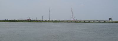
The John B. Whealton Memorial Causeway connects Virginia's mainland to Chincoteague Island and consists of five bridge sections spanning multiple water channels. The structure features four fixed bridges and one drawbridge following State Route 175, with a single lane in each direction.

State approval came in September 1919, leading to construction with a budget of 144,000 dollars and opening on November 15, 1922. The bridge was built to connect the isolated island to the mainland and enable access to its resources and communities.

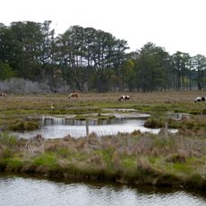
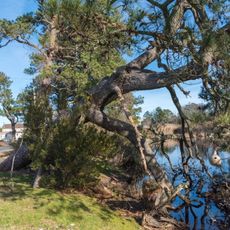
The causeway serves as the main passage to Chincoteague Island's famous annual pony swim, an event that draws visitors from across the region. It connects people with the wildlife refuge and its distinctive animal populations in a way that shapes the island's identity.

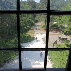
Driving across the causeway is straightforward and well marked, though the drawbridge occasionally rises to allow boats through. Visitors should stay focused on the road and drive slowly, especially when the drawbridge is in operation.

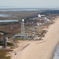
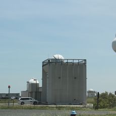
While crossing, travelers can spot NASA Wallops Flight Facility's satellite dishes and research equipment behind security fencing. This aerospace facility remains largely hidden but offers a brief glimpse into the scientific activity happening in the area.

The community of curious travelers

AroundUs brings together thousands of curated places, local tips, and hidden gems, enriched daily by 60,000 contributors worldwide.

Start exploring
Official opening
November 15, 1922
GPS coordinates
37.93500,-75.41849
Latest update
December 14, 2025 11:03
Around this place
Chincoteague National Wildlife Refuge
United States of America

Chincoteague National Wildlife Refuge

9.2 km
Assateague Light
United States of America

Assateague Light

6.1 km
NASA Visitor Center
United States of America

NASA Visitor Center

3.4 km
Captain Timothy Hill House
United States of America

Captain Timothy Hill House

5.6 km
Costen House
United States of America

Costen House

20.3 km
Museum of Chincoteague Island
United States of America

Museum of Chincoteague Island

5.6 km
NASA's Wallops Flight Facility Visitor Center
United States of America

NASA's Wallops Flight Facility Visitor Center

3.4 km
Assateague Beach Coast Guard Station
United States of America

Assateague Beach Coast Guard Station

9.1 km
Arbuckle Place
United States of America

Arbuckle Place

11.7 km
Refuge Waterfowl Museum
United States of America

Refuge Waterfowl Museum

5.8 km
Wharton Place
United States of America

Wharton Place

14 km
Pitts Neck
United States of America

Pitts Neck

18.9 km
Young-Sartorius House
United States of America

Young-Sartorius House

20.1 km
Chincoteague Island Library
United States of America

Chincoteague Island Library

3.6 km
Pocomoke Farm
United States of America

Pocomoke Farm

19.1 km
Watson House
United States of America

Watson House

4.1 km
Pocomoke City Historic District
United States of America

Pocomoke City Historic District

20.1 km
Crockett House
United States of America

Crockett House

19.4 km
Littleton T. Clarke House
United States of America

Littleton T. Clarke House

20.1 km
Museum of Chincoteague Island
United States of America

Museum of Chincoteague Island

5.9 km
Maui Jack's Waterpark
United States of America

Maui Jack's Waterpark

5.6 km
Captain Timothy Hill House
United States of America

Captain Timothy Hill House

5.6 km
Herbert H. Bateman Educational and Administrative Center
United States of America

Herbert H. Bateman Educational and Administrative Center

6.2 km
Wallops Beach
United States of America

Wallops Beach

10.2 km
Killock Shoal Light
United States of America

Killock Shoal Light

3.4 km
Toms Cove Visitor Center
United States of America

Toms Cove Visitor Center

8.2 km
Lighthouse Trail
United States of America

Lighthouse Trail

6.3 km
NASA Wallops Island
United States of America

NASA Wallops Island

11.3 km
Show the full map
Reviews
Share your experience

No review yet

Discussions
Start a discussion...

No discussion yet

« John B. Whealton Memorial Causeway - Road bridge at Chincoteague Island, Virginia, US » is provided by Around Us (aroundus.com). Images and texts are derived from Wikimedia project under a Creative Commons license. You are allowed to copy, distribute, and modify copies of this page, under the conditions set by the license, as long as this note is clearly visible.

Discover hidden gems everywhere you go!

From secret cafés to breathtaking viewpoints, skip the crowded tourist spots and find places that match your style. Our app makes it easy with voice search, smart filtering, route optimization, and insider tips from travelers worldwide. Download now for the complete mobile experience.

Around Us App Screenshot

A unique approach to discovering new places

Le Figaro

All the places worth exploring

France Info

A tailor-made excursion in just a few clicks

20 Minutes

Around Us
Travel Guide & Maps
Download

Send to your phone

QR Code
1

Open the camera app on your mobile.

2

Point at the QR code with your camera. A notification will appear.

3

Tap the notification to open the link.