Enable Location

We need your location to show you interesting places around you

Discover nearby places

Find interesting locations and hidden gems around you

Precise directions

Get accurate directions and distances to places

Your location is never shared with other users. It's only used when you tap the location button.

Assateague Light

Log in to your account

Start exploring — it's free

Trusted by 65,227 travelers worldwide

Continue with Google
Continue with Apple
or

We will send you a code to connect

By continuing, you accept our Terms and Conditions and our Privacy Policy

Check your inbox

We've sent a pincode in your inbox. Please enter the code below.

Discussion Reviews 1 Photos
5.8k Popularity

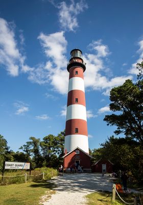
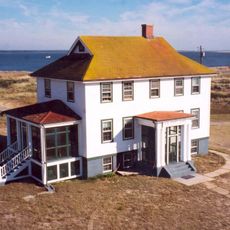
Assateague Light, Maritime navigation beacon on Assateague Island, Virginia, United States.

Assateague Light is a red and white striped lighthouse on Assateague Island in Virginia, standing about 141 feet (43 meters) tall. Inside, a narrow spiral staircase leads up to the lantern room, where rotating light beams guide ships along the coast.

The current tower was built in 1867 to replace an earlier, shorter lighthouse that did not give ships enough warning along the Virginia coast. Congress ordered the new structure after it became clear that the original tower was too small for the waters it was meant to serve.

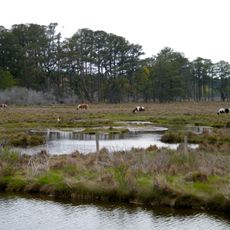
The lighthouse stands within the Chincoteague National Wildlife Refuge and acts as a natural reference point for visitors exploring the shoreline and wetlands. Its red and white stripes are visible from a distance, making it one of the most recognizable landmarks on the island.

The tower is open to climb on Saturdays from April through November, with morning and afternoon sessions available. The interior staircase is narrow and steep, so wear sturdy shoes and take your time going up.

Although the tower is listed as a historic landmark, it still sends out an active light signal used by ships at sea today. This makes it one of the few historic towers on the East Coast that is both open to visitors and in full working use.

The community of curious travelers

AroundUs brings together thousands of curated places, local tips, and hidden gems, enriched daily by 60,000 contributors worldwide.

Start exploring
Location
Height
43 m
GPS coordinates
37.91110,-75.35580
Latest update
March 3, 2026 10:09
Around this place
Chincoteague National Wildlife Refuge
United States of America

Chincoteague National Wildlife Refuge

5.9 km
NASA Visitor Center
United States of America

NASA Visitor Center

9.4 km
Captain Timothy Hill House
United States of America

Captain Timothy Hill House

4.1 km
John B. Whealton Memorial Causeway
United States of America

John B. Whealton Memorial Causeway

6.1 km
Museum of Chincoteague Island
United States of America

Museum of Chincoteague Island

1.9 km
NASA's Wallops Flight Facility Visitor Center
United States of America

NASA's Wallops Flight Facility Visitor Center

9.4 km
Assateague Beach Coast Guard Station
United States of America

Assateague Beach Coast Guard Station

5.4 km
Island Theatre
United States of America

Island Theatre

3.1 km
Arbuckle Place
United States of America

Arbuckle Place

15.6 km
Refuge Waterfowl Museum
United States of America

Refuge Waterfowl Museum

1.5 km
Wharton Place
United States of America

Wharton Place

17.1 km
Pitts Neck
United States of America

Pitts Neck

24.9 km
Young-Sartorius House
United States of America

Young-Sartorius House

25.8 km
Chincoteague Island Library
United States of America

Chincoteague Island Library

3.2 km
Pocomoke Farm
United States of America

Pocomoke Farm

24.7 km
Watson House
United States of America

Watson House

3.1 km
Pocomoke City Historic District
United States of America

Pocomoke City Historic District

25.8 km
Crockett House
United States of America

Crockett House

25.1 km
Littleton T. Clarke House
United States of America

Littleton T. Clarke House

25.9 km
Museum of Chincoteague Island
United States of America

Museum of Chincoteague Island

1.4 km
Captain Timothy Hill House
United States of America

Captain Timothy Hill House

4.1 km
Herbert H. Bateman Educational and Administrative Center
United States of America

Herbert H. Bateman Educational and Administrative Center

276 m
Wallops Beach
United States of America

Wallops Beach

11.8 km
Killock Shoal Light
United States of America

Killock Shoal Light

3.3 km
Toms Cove Visitor Center
United States of America

Toms Cove Visitor Center

2.5 km
NASA Wallops Island
United States of America

NASA Wallops Island

13.2 km
Lighthouse Trail
United States of America

Lighthouse Trail

189 m
NASA Wallops Island bridge
United States of America

NASA Wallops Island bridge

13.6 km
Show the full map
Reviews
Share your experience

No review yet

Discussions
Start a discussion...

No discussion yet

« Assateague Light - Maritime navigation beacon on Assateague Island, Virginia, United States » is provided by Around Us (aroundus.com). Images and texts are derived from Wikimedia project under a Creative Commons license. You are allowed to copy, distribute, and modify copies of this page, under the conditions set by the license, as long as this note is clearly visible.

Discover hidden gems everywhere you go!

From secret cafés to breathtaking viewpoints, skip the crowded tourist spots and find places that match your style. Our app makes it easy with voice search, smart filtering, route optimization, and insider tips from travelers worldwide. Download now for the complete mobile experience.

Around Us App Screenshot

A unique approach to discovering new places

Le Figaro

All the places worth exploring

France Info

A tailor-made excursion in just a few clicks

20 Minutes

Around Us
Travel Guide & Maps
Download

Send to your phone

QR Code
1

Open the camera app on your mobile.

2

Point at the QR code with your camera. A notification will appear.

3

Tap the notification to open the link.