Enable Location

We need your location to show you interesting places around you

Discover nearby places

Find interesting locations and hidden gems around you

Precise directions

Get accurate directions and distances to places

Your location is never shared with other users. It's only used when you tap the location button.

Kettle Pond State Park

Log in to your account

Start exploring — it's free

Trusted by 62,302 travelers worldwide

Continue with Google
Continue with Apple
or

We will send you a code to connect

By continuing, you accept our Terms and Conditions and our Privacy Policy

Check your inbox

We've sent a pincode in your inbox. Please enter the code below.

Kettle Pond State Park

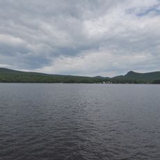
Kettle Pond State Park, State park with camping facilities in Marshfield, United States.

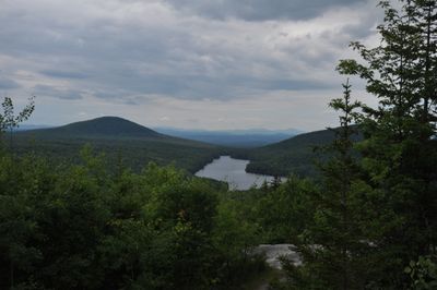
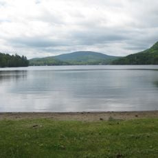
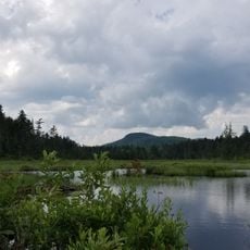
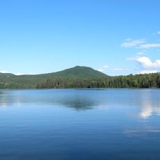
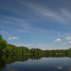
Kettle Pond State Park is a forest park in Marshfield featuring a large pond at its center and trails throughout the surrounding woodland. The grounds provide various overnight options, from simple shelters near the water to remote camping spots deeper in the forest.

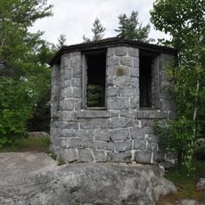
The site served as a travel route for Native Americans and was used by French explorers during early colonial times. The land later became a logging area before being converted into a recreational park in modern times.

The park serves as a gathering place where people experience Vermont's natural world through outdoor recreation. Visitors and locals alike use the space to connect with the forest and water in simple, direct ways.

The park offers trails and campsites suitable for different experience levels, ranging from waterside to deep forest locations. Visitors should plan to bring water and expect basic facilities, as this is a largely undeveloped area.

The pond is home to a breeding population of loons, water birds that swimmers and paddlers often encounter throughout the season. These birds indicate the water's natural, undisturbed state.

The community of curious travelers

AroundUs brings together thousands of curated places, local tips, and hidden gems, enriched daily by 60,000 contributors worldwide.

Start exploring
Location
GPS coordinates
44.29440,-72.30780
Latest update
December 6, 2025 17:46
Hidden places in Vermont: granite quarries, covered bridges, historic villages

Vermont hides historic places away from main roads, often forgotten by hurried travelers. Here you find granite quarries still working or long abandoned, small rural schools from the 1800s where children learned together, wooden covered bridges, and waterfalls flowing through thick forests. Trails...

Around this place
Harvey's Lake
United States of America

Harvey's Lake

13.5 km
Groton State Forest
United States of America

Groton State Forest

2.4 km
Greenbanks Hollow Covered Bridge
United States of America

Greenbanks Hollow Covered Bridge

17.4 km
Molly's Falls Pond State Park
United States of America

Molly's Falls Pond State Park

7.7 km
Ricker Pond State Park
United States of America

Ricker Pond State Park

6.9 km
New Discovery State Park
United States of America

New Discovery State Park

3.2 km
Elkins Tavern
United States of America

Elkins Tavern

11.7 km
Stillwater State Park
United States of America

Stillwater State Park

3.2 km
Martin Covered Bridge
United States of America

Martin Covered Bridge

8 km
Coburn Covered Bridge
United States of America

Coburn Covered Bridge

11.8 km
Whitehill House
United States of America

Whitehill House

11.1 km
Robbins Nest Covered Bridge
United States of America

Robbins Nest Covered Bridge

18.2 km
Allenwood Farm
United States of America

Allenwood Farm

10.2 km
Kents Corner Historic District
United States of America

Kents Corner Historic District

16.4 km
Alice Lord Goodine House
United States of America

Alice Lord Goodine House

13 km
Whittier House
United States of America

Whittier House

17.5 km
East Village Meetinghouse
United States of America

East Village Meetinghouse

14.6 km
Lind Houses
United States of America

Lind Houses

18.2 km
J. R. Darling Store
United States of America

J. R. Darling Store

12.8 km
Barnet Center Historic District
United States of America

Barnet Center Historic District

17.8 km
Peacham Corner Historic District
United States of America

Peacham Corner Historic District

11.4 km
North Calais Village Historic District
United States of America

North Calais Village Historic District

15.2 km
Parley Davis House
United States of America

Parley Davis House

17.7 km
Theodore Wood House
United States of America

Theodore Wood House

8.5 km
Gale-Bancroft House
United States of America

Gale-Bancroft House

9.4 km
Plainfield Village Historic District
United States of America

Plainfield Village Historic District

9.5 km
Peacham
United States of America

Peacham

11.6 km
Cutler Memorial
United States of America

Cutler Memorial

9.8 km
Show the full map
« Kettle Pond State Park - State park with camping facilities in Marshfield, United States » is provided by Around Us (aroundus.com). Images and texts are derived from Wikimedia project under a Creative Commons license. You are allowed to copy, distribute, and modify copies of this page, under the conditions set by the license, as long as this note is clearly visible.

Discover hidden gems everywhere you go!

From secret cafés to breathtaking viewpoints, skip the crowded tourist spots and find places that match your style. Our app makes it easy with voice search, smart filtering, route optimization, and insider tips from travelers worldwide. Download now for the complete mobile experience.

Around Us App Screenshot

A unique approach to discovering new places

Le Figaro

All the places worth exploring

France Info

A tailor-made excursion in just a few clicks

20 Minutes

Around Us
Travel Guide & Maps
Download

Send to your phone

QR Code
1

Open the camera app on your mobile.

2

Point at the QR code with your camera. A notification will appear.

3

Tap the notification to open the link.