Enable Location

We need your location to show you interesting places around you

Discover nearby places

Find interesting locations and hidden gems around you

Precise directions

Get accurate directions and distances to places

Your location is never shared with other users. It's only used when you tap the location button.

LeTort Spring Run Nature Trail

Log in to your account

Start exploring — it's free

Trusted by 61,838 travelers worldwide

Continue with Google
Continue with Apple
or

We will send you a code to connect

By continuing, you accept our Terms and Conditions and our Privacy Policy

Check your inbox

We've sent a pincode in your inbox. Please enter the code below.

LeTort Spring Run Nature Trail

LeTort Spring Run Nature Trail, Nature trail in Carlisle, United States.

Description

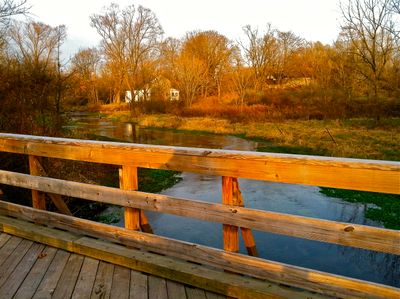
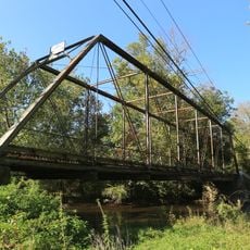
The LeTort Spring Run Nature Trail is a hiking path that winds through Carlisle and South Middleton Township, tracing a limestone creek with a gravel surface. The route spans approximately 2.5 miles and includes distance markers and interpretive signs placed at regular intervals to help visitors along the way.

History

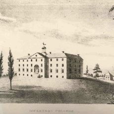
In the 1720s, James Le Tort established a trading post near this waterway before Scots-Irish settlers arrived in the region. This early European presence influenced how Carlisle developed over the following generations.

Culture

The waterway bears the name of James Le Tort, a French-Canadian interpreter from the early 1700s whose presence shaped the area's early development. Today, locals and visitors use the paths to observe wildlife and connect with the flowing water that defines this landscape.

Practical

The path features an eight-foot-wide gravel surface and can be accessed from several locations including Letort Park and Lamberton Middle School. Wear comfortable shoes and be prepared for occasional muddy spots, especially after rainfall.

Did you know?

The path includes a native plant garden covering about four thousand square feet, created in 2016 to prevent erosion and support local wildlife. This section demonstrates how conservation efforts directly improve the health of the creek and surrounding landscape.

Location
Inception
1974
GPS coordinates
40.18300,-77.18720
Latest update
December 14, 2025 14:41

AroundUs brings together thousands of curated places, local tips, and hidden gems, enriched daily by 60,000 contributors worldwide. Discover all places nearby (Carlisle).

Around this place
Pine Grove Furnace State Park
United States of America

Pine Grove Furnace State Park

19.7 km
U.S. Army Heritage and Education Center
United States of America

U.S. Army Heritage and Education Center

3.6 km
Appalachian Trail Museum
United States of America

Appalachian Trail Museum

19.5 km
Cumberland Drive-In
United States of America

Cumberland Drive-In

15.8 km
Kings Gap Environmental Education and Training Center
United States of America

Kings Gap Environmental Education and Training Center

13 km
Old West, Dickinson College
United States of America

Old West, Dickinson College

2.3 km
Hessian Powder Magazine
United States of America

Hessian Powder Magazine

1.8 km
Irving Female College
United States of America

Irving Female College

16.3 km
Amelia S. Givin Free Library
United States of America

Amelia S. Givin Free Library

7.4 km
Gilbert Bridge
United States of America

Gilbert Bridge

17.7 km
Dellville Covered Bridge
United States of America

Dellville Covered Bridge

21 km
Adam Orris House
United States of America

Adam Orris House

15.1 km
Johannes Eberly House
United States of America

Johannes Eberly House

18.9 km
Carlisle Historic District
United States of America

Carlisle Historic District

2.2 km
John Williams House
United States of America

John Williams House

13.9 km
Carlisle Armory
United States of America

Carlisle Armory

4.2 km
Rice Covered Bridge
United States of America

Rice Covered Bridge

19.9 km
Mechanicsburg Commercial Historic District
United States of America

Mechanicsburg Commercial Historic District

15.5 km
Boiling Springs Historic District
United States of America

Boiling Springs Historic District

6.4 km
George Trimble House
United States of America

George Trimble House

15.2 km
Newville Historic District
United States of America

Newville Historic District

18 km
Cline's Church of the United Brethren in Christ
United States of America

Cline's Church of the United Brethren in Christ

20.5 km
Dunbar-Creigh House
United States of America

Dunbar-Creigh House

20.4 km
Rev. Anderson B. Quay House
United States of America

Rev. Anderson B. Quay House

15.1 km
Henry and Elizabeth Berkheimer Farm
United States of America

Henry and Elizabeth Berkheimer Farm

21.7 km
Dill's Tavern
United States of America

Dill's Tavern

14.8 km
The Oakes Museum of Natural History
United States of America

The Oakes Museum of Natural History

17.2 km
James Given Tavern
United States of America

James Given Tavern

2.8 km
Show the full map
« LeTort Spring Run Nature Trail - Nature trail in Carlisle, United States » is provided by Around Us (aroundus.com). Images and texts are derived from Wikimedia project under a Creative Commons license. You are allowed to copy, distribute, and modify copies of this page, under the conditions set by the license, as long as this note is clearly visible.

Discover hidden gems everywhere you go!

From secret cafés to breathtaking viewpoints, skip the crowded tourist spots and find places that match your style. Our app makes it easy with voice search, smart filtering, route optimization, and insider tips from travelers worldwide. Download now for the complete mobile experience.

Around Us App Screenshot

A unique approach to discovering new places

Le Figaro

All the places worth exploring

France Info

A tailor-made excursion in just a few clicks

20 Minutes

Around Us
Travel Guide & Maps
Download

Send to your phone

QR Code
1

Open the camera app on your mobile.

2

Point at the QR code with your camera. A notification will appear.

3

Tap the notification to open the link.