McGees Mills Covered Bridge

Log in to your account

AroundUs is a community-driven map of interesting places, built by curious explorers like you. It grows with every review, story, and photo you share.
Connect to save your favorite spots, contribute locations, and create personalized routes.
Continue with Google
Continue with Apple
Continue with X
Continue with Facebook
Continue with email
By continuing, you accept our Terms and Conditions and our Privacy Policy
Create an account
Add to collection
Map
Suggest a change
Share

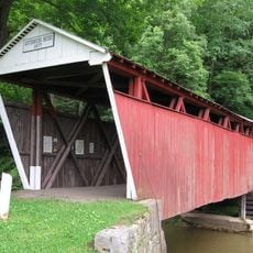
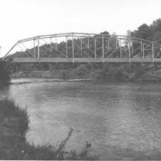
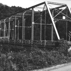
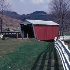
McGees Mills Covered Bridge, 1873 covered bridge near Mahaffey, Pennsylvania.

McGees Mills Covered Bridge spans approximately 109 feet over the West Branch of the Susquehanna River using a single-span Burr truss design made from white pine timber. The structure exemplifies typical bridge-building methods of the 1800s.

Thomas McGee built this bridge in 1873, making it the last one constructed in Clearfield County before being added to the National Register of Historic Places. The structure represents the final phase of covered bridge building in this area.

The bridge displays handcrafted construction methods from the 1800s, with locally sourced white pine timbers and traditional arched supports that are visible throughout the structure. Visitors can observe these building techniques directly when crossing.

Parking areas are available on the northwest side of the bridge, accessible via Route 219 and Covered Bridge Road for easy location. The site is straightforward to reach and navigate on foot.

This remains the only covered bridge still crossing the Susquehanna River, standing alone as a rare survivor of this building style in the region. Its isolated status makes it a valuable monument to an era of bridge construction now largely gone elsewhere.
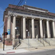
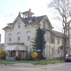
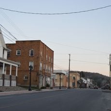
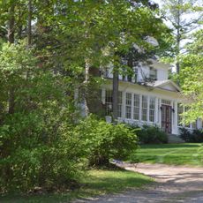
Location: Pennsylvania

GPS coordinates: 40.88000,-78.76528

Latest update: December 14, 2025 18:03

Photos
Around this place
Prince Gallitzin State Park
United States of America

Prince Gallitzin State Park

29.9 km
Bilger's Rocks
United States of America

Bilger's Rocks

19.2 km
Curwensville Lake
United States of America

Curwensville Lake

21.7 km
Clearfield County Courthouse
United States of America

Clearfield County Courthouse

31.8 km
John B. McCormick House
United States of America

John B. McCormick House

30 km
United States Post Office
United States of America

United States Post Office

18.8 km
Irvin-Patchin House
United States of America

Irvin-Patchin House

7.4 km
T. M. Kurtz House
United States of America

T. M. Kurtz House

18.8 km
Kintersburg Covered Bridge
United States of America

Kintersburg Covered Bridge

32.5 km
Christian Miller House
United States of America

Christian Miller House

18.9 km
Old Town Historic District
United States of America

Old Town Historic District

31.6 km
DuBois Historic District
United States of America

DuBois Historic District

26.6 km
Hogback Bridge
United States of America

Hogback Bridge

25.3 km
Thomas Murray House
United States of America

Thomas Murray House

31.6 km
Coalport Historic District
United States of America

Coalport Historic District

24.3 km
Sen. Joseph O. Clark House
United States of America

Sen. Joseph O. Clark House

8.7 km
Bridge in Greenwood Township
United States of America

Bridge in Greenwood Township

10.5 km
Harmon's Covered Bridge
United States of America

Harmon's Covered Bridge

32.5 km
S. B. Elliott State Park
United States of America

S. B. Elliott State Park

32.1 km
Patton Historic District
United States of America

Patton Historic District

28.8 km
Bridge in Westover Borough
United States of America

Bridge in Westover Borough

16.4 km
Market Street Bridge
United States of America

Market Street Bridge

31.5 km
S. B. Elliott State Park Family Cabin District
United States of America

S. B. Elliott State Park Family Cabin District

32.9 km
S. B. Elliott State Park Day Use District
United States of America

S. B. Elliott State Park Day Use District

32.8 km
Punxsutawney Weather Discovery Center
United States of America

Punxsutawney Weather Discovery Center

18.8 km
Laurel Mountain Winery
United States of America

Laurel Mountain Winery

34.8 km
Clearfield Presbyterian Church
United States of America

Clearfield Presbyterian Church

31.9 km
Commodore Historic District
United States of America

Commodore Historic District

23.9 km
Show the full map
Reviews

Visited this place? Tap the stars to rate it and share your experience / photos with the community! Try now! You can cancel it anytime.

« McGees Mills Covered Bridge - 1873 covered bridge near Mahaffey, Pennsylvania » is provided by Around Us (aroundus.com). Images and texts are derived from Wikimedia project under a Creative Commons license. You are allowed to copy, distribute, and modify copies of this page, under the conditions set by the license, as long as this note is clearly visible.

Discover hidden gems everywhere you go!

From secret cafés to breathtaking viewpoints, skip the crowded tourist spots and find places that match your style. Our app makes it easy with voice search, smart filtering, route optimization, and insider tips from travelers worldwide. Download now for the complete mobile experience.

Around Us App Screenshot

A unique approach to discovering new places

Le Figaro

All the places worth exploring

France Info

A tailor-made excursion in just a few clicks

20 Minutes