Bilger's Rocks

Log in to your account

AroundUs is a community-driven map of interesting places, built by curious explorers like you. It grows with every review, story, and photo you share.
Connect to save your favorite spots, contribute locations, and create personalized routes.
Continue with Google
Continue with Apple
Continue with X
Continue with Facebook
Continue with email
By continuing, you accept our Terms and Conditions and our Privacy Policy
Create an account
Add to collection
Map
Suggest a change
Share

Bilger's Rocks, Rock formation park in Clearfield County, US

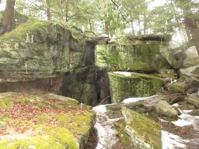
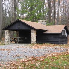
Bilger's Rocks is a park featuring massive sandstone formations that rise to heights of around 50 feet and create natural passageways, caves, and corridors throughout the property. The site includes hiking trails, camping areas, picnic pavilions, an outdoor stage, and a playground.

The sandstone formations originated about 300 million years ago during the Paleozoic era and have defined the landscape of the Allegheny Mountains since then. The park was later developed to make these geological structures accessible to the public.

The rock formations carry names rooted in local folklore, such as Devil's Dining Room and Devil's Kitchen, showing how the community has made sense of these spaces over time. These names shape how visitors experience and navigate different sections of the site.

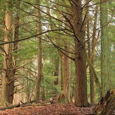
The site is best explored on foot, with a mix of wider paths and narrow trails winding between the rocks. It is wise to wear sturdy shoes and visit during daylight hours to safely navigate the uneven terrain.

The area maintains cooler temperatures than its surroundings year-round, with ice and snow persisting in deep fissures even on warmer days. This thermal oddity delights visitors who encounter unexpected cool spots during summer hikes.

Location: Clearfield County

GPS coordinates: 40.99333,-78.59306

Latest update: December 10, 2025 20:08

Photos
Around this place
Parker Dam State Park
United States of America

Parker Dam State Park

24.3 km
Moshannon State Forest
United States of America

Moshannon State Forest

24 km
Curwensville Lake
United States of America

Curwensville Lake

7.1 km
Clearfield County Courthouse
United States of America

Clearfield County Courthouse

13.4 km
United States Post Office
United States of America

United States Post Office

32.3 km
Irvin-Patchin House
United States of America

Irvin-Patchin House

25.7 km
McGees Mills Covered Bridge
United States of America

McGees Mills Covered Bridge

19.2 km
T. M. Kurtz House
United States of America

T. M. Kurtz House

32.4 km
Christian Miller House
United States of America

Christian Miller House

32.5 km
Old Town Historic District
United States of America

Old Town Historic District

13.3 km
DuBois Historic District
United States of America

DuBois Historic District

20 km
Hogback Bridge
United States of America

Hogback Bridge

8.9 km
Thomas Murray House
United States of America

Thomas Murray House

13.4 km
Herpel Brothers Foundry and Machine Shop
United States of America

Herpel Brothers Foundry and Machine Shop

27.8 km
Coalport Historic District
United States of America

Coalport Historic District

27.8 km
Sen. Joseph O. Clark House
United States of America

Sen. Joseph O. Clark House

27.8 km
Bridge in Greenwood Township
United States of America

Bridge in Greenwood Township

10.3 km
S. B. Elliott State Park
United States of America

S. B. Elliott State Park

13.8 km
Bridge in Westover Borough
United States of America

Bridge in Westover Borough

27.5 km
Market Street Bridge
United States of America

Market Street Bridge

13.1 km
Redferd Segers House
United States of America

Redferd Segers House

31.8 km
Parker Dam State Park Family Cabin District
United States of America

Parker Dam State Park Family Cabin District

23.6 km
S. B. Elliott State Park Family Cabin District
United States of America

S. B. Elliott State Park Family Cabin District

14.5 km
S. B. Elliott State Park Day Use District
United States of America

S. B. Elliott State Park Day Use District

14.5 km
Punxsutawney Weather Discovery Center
United States of America

Punxsutawney Weather Discovery Center

32.3 km
Laurel Mountain Winery
United States of America

Laurel Mountain Winery

28.4 km
Clearfield Presbyterian Church
United States of America

Clearfield Presbyterian Church

13.5 km
Parker Dam State Park-Parker Dam District
United States of America

Parker Dam State Park-Parker Dam District

23.9 km
Show the full map
Reviews

Visited this place? Tap the stars to rate it and share your experience / photos with the community! Try now! You can cancel it anytime.

« Bilger's Rocks - Rock formation park in Clearfield County, US » is provided by Around Us (aroundus.com). Images and texts are derived from Wikimedia project under a Creative Commons license. You are allowed to copy, distribute, and modify copies of this page, under the conditions set by the license, as long as this note is clearly visible.

Discover hidden gems everywhere you go!

From secret cafés to breathtaking viewpoints, skip the crowded tourist spots and find places that match your style. Our app makes it easy with voice search, smart filtering, route optimization, and insider tips from travelers worldwide. Download now for the complete mobile experience.

Around Us App Screenshot

A unique approach to discovering new places

Le Figaro

All the places worth exploring

France Info

A tailor-made excursion in just a few clicks

20 Minutes