Clearfield County Courthouse

Log in to your account

AroundUs is a community-driven map of interesting places, built by curious explorers like you. It grows with every review, story, and photo you share.
Connect to save your favorite spots, contribute locations, and create personalized routes.
Continue with Google
Continue with Apple
Continue with X
Continue with Facebook
Continue with email
By continuing, you accept our Terms and Conditions and our Privacy Policy
Create an account
Add to collection
Map
Suggest a change
Share

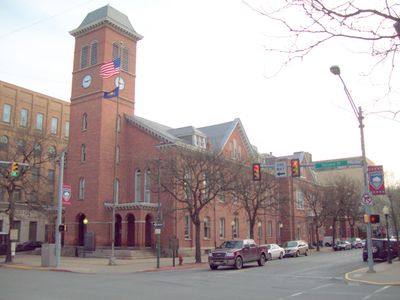
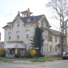
Clearfield County Courthouse, County courthouse in Clearfield, Pennsylvania, United States.

Clearfield County Courthouse is a brick administrative building featuring a distinctive clock tower topped with a bell-shaped roof in the Second Empire architectural style. The 2.5-story structure occupies a central position in the downtown area with its square tower as the defining visual feature.

The courthouse was constructed during the Civil War era using materials salvaged from an earlier 1814 building that previously stood on the site. Its completion represents a significant moment in Clearfield's architectural development during the 1860s.

The courthouse functions as the civic center of Clearfield, anchoring the town's sense of official identity and responsibility. Visitors notice how its prominent position reflects the importance of law and governance in the local community.

The building sits in downtown Clearfield within walking distance of shops and local services, making it easy to visit as part of a walking tour. Plan your visit during business hours when the public areas are accessible and staff are available.

The structure with its mansard roof design remains the longest continuously used public building in Clearfield County since its completion. This longevity reveals how thoughtful architectural design allowed the building to serve generations without replacement.

Location: Clearfield

Inception: 1860

Architectural style: Second Empire style

GPS coordinates: 41.02222,-78.43778

Latest update: December 14, 2025 14:22

Photos
Around this place
Quehanna Wild Area
United States of America

Quehanna Wild Area

31.9 km
Parker Dam State Park
United States of America

Parker Dam State Park

20.8 km
Bilger's Rocks
United States of America

Bilger's Rocks

13.4 km
Moshannon State Forest
United States of America

Moshannon State Forest

23.7 km
Rowland Theater
United States of America

Rowland Theater

22.8 km
Marion Brooks Natural Area
United States of America

Marion Brooks Natural Area

30.9 km
Wykoff Run Natural Area
United States of America

Wykoff Run Natural Area

31 km
Curwensville Lake
United States of America

Curwensville Lake

10.6 km
St. Severin's Old Log Church
United States of America

St. Severin's Old Log Church

27.5 km
McGees Mills Covered Bridge
United States of America

McGees Mills Covered Bridge

31.8 km
Philipsburg Historic District
United States of America

Philipsburg Historic District

23 km
Hardman Philips House
United States of America

Hardman Philips House

23.4 km
Old Town Historic District
United States of America

Old Town Historic District

187 m
DuBois Historic District
United States of America

DuBois Historic District

29.4 km
Hogback Bridge
United States of America

Hogback Bridge

7 km
Thomas Murray House
United States of America

Thomas Murray House

248 m
Coalport Historic District
United States of America

Coalport Historic District

31.7 km
Bridge in Greenwood Township
United States of America

Bridge in Greenwood Township

21.6 km
S. B. Elliott State Park
United States of America

S. B. Elliott State Park

12.5 km
Market Street Bridge
United States of America

Market Street Bridge

331 m
Parker Dam State Park Family Cabin District
United States of America

Parker Dam State Park Family Cabin District

20.6 km
S. B. Elliott State Park Family Cabin District
United States of America

S. B. Elliott State Park Family Cabin District

12.3 km
S. B. Elliott State Park Day Use District
United States of America

S. B. Elliott State Park Day Use District

12.5 km
Black Moshannon State Park Day Use District
United States of America

Black Moshannon State Park Day Use District

33.9 km
Black Moshannon State Park Family Cabin District
United States of America

Black Moshannon State Park Family Cabin District

33.8 km
Clearfield Presbyterian Church
United States of America

Clearfield Presbyterian Church

225 m
Parker Dam State Park-Parker Dam District
United States of America

Parker Dam State Park-Parker Dam District

20.5 km
Black Moshannon State Park Maintenance District
United States of America

Black Moshannon State Park Maintenance District

32.6 km
Show the full map
Reviews

Visited this place? Tap the stars to rate it and share your experience / photos with the community! Try now! You can cancel it anytime.

« Clearfield County Courthouse - County courthouse in Clearfield, Pennsylvania, United States » is provided by Around Us (aroundus.com). Images and texts are derived from Wikimedia project under a Creative Commons license. You are allowed to copy, distribute, and modify copies of this page, under the conditions set by the license, as long as this note is clearly visible.

Discover hidden gems everywhere you go!

From secret cafés to breathtaking viewpoints, skip the crowded tourist spots and find places that match your style. Our app makes it easy with voice search, smart filtering, route optimization, and insider tips from travelers worldwide. Download now for the complete mobile experience.

Around Us App Screenshot

A unique approach to discovering new places

Le Figaro

All the places worth exploring

France Info

A tailor-made excursion in just a few clicks

20 Minutes