Enable Location

We need your location to show you interesting places around you

Discover nearby places

Find interesting locations and hidden gems around you

Precise directions

Get accurate directions and distances to places

Your location is never shared with other users. It's only used when you tap the location button.

Marion Brooks Natural Area

Log in to your account

Start exploring — it's free

Trusted by 63,313 travelers worldwide

Continue with Google
Continue with Apple
or

We will send you a code to connect

By continuing, you accept our Terms and Conditions and our Privacy Policy

Check your inbox

We've sent a pincode in your inbox. Please enter the code below.

Marion Brooks Natural Area
Discussion Reviews 1 Photos
2.2k Popularity

Marion Brooks Natural Area, Protected natural area in Benezette Township, Elk County, Pennsylvania, United States.

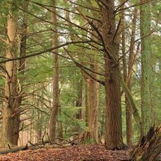
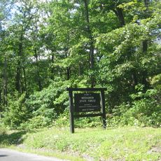
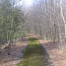
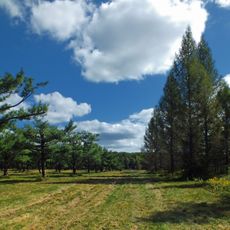
Marion Brooks Natural Area is a protected landscape spanning 917 acres within Moshannon State Forest, characterized by extensive white birch woodlands. The terrain varies across the property with dense forest stands and diverse plant communities.

The site was originally called Paige Run Natural Area until 1975, when it was renamed to honor environmental advocate Marion E. Brooks. The change marked growing recognition of the location's role in regional conservation efforts.

The protected landscape serves as a study site for ecological research, focusing on the preservation of white birch trees at their southern natural limit.

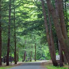
Access is available from a parking area on Losey Road, from which a three-mile loop trail with yellow blazes winds through varying forest types. The route is clearly marked and guides visitors through the different woodland sections.

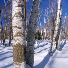
The site contains one of the largest white birch groves in eastern North America, including a remarkable specimen with four trunks reaching about 50 feet (15 m) tall. This unusual growth form is rare among birches and draws attention from nature observers.

The community of curious travelers

AroundUs brings together thousands of curated places, local tips, and hidden gems, enriched daily by 60,000 contributors worldwide.

Start exploring
Location
GPS coordinates
41.27630,-78.28790
Latest update
December 13, 2025 17:07
Around this place
Quehanna Wild Area
United States of America

Quehanna Wild Area

2.6 km
Parker Dam State Park
United States of America

Parker Dam State Park

20.3 km
Kettle Creek State Park
United States of America

Kettle Creek State Park

32.7 km
Sinnemahoning State Park
United States of America

Sinnemahoning State Park

27.6 km
Moshannon State Forest
United States of America

Moshannon State Forest

25.2 km
Elk State Forest
United States of America

Elk State Forest

6.4 km
Bucktail State Park Natural Area
United States of America

Bucktail State Park Natural Area

26.7 km
Sizerville State Park
United States of America

Sizerville State Park

36.3 km
Wykoff Run Natural Area
United States of America

Wykoff Run Natural Area

9.1 km
Clearfield County Courthouse
United States of America

Clearfield County Courthouse

30.9 km
St. Severin's Old Log Church
United States of America

St. Severin's Old Log Church

31 km
Parker Dam State Park Beach
United States of America

Parker Dam State Park Beach

20.6 km
St. Marys Historic District
United States of America

St. Marys Historic District

28.6 km
Old Town Historic District
United States of America

Old Town Historic District

31 km
Cameron County Courthouse
United States of America

Cameron County Courthouse

26.7 km
Ridgway Historic District
United States of America

Ridgway Historic District

40.1 km
Hogback Bridge
United States of America

Hogback Bridge

37.7 km
John E. Weidenboerner House
United States of America

John E. Weidenboerner House

28.6 km
Thomas Murray House
United States of America

Thomas Murray House

31.2 km
Johnsonburg Commercial Historic District
United States of America

Johnsonburg Commercial Historic District

40.1 km
S. B. Elliott State Park
United States of America

S. B. Elliott State Park

27.8 km
Market Street Bridge
United States of America

Market Street Bridge

31.1 km
Parker Dam State Park Family Cabin District
United States of America

Parker Dam State Park Family Cabin District

21 km
S. B. Elliott State Park Family Cabin District
United States of America

S. B. Elliott State Park Family Cabin District

26.9 km
S. B. Elliott State Park Day Use District
United States of America

S. B. Elliott State Park Day Use District

27 km
Clearfield Lanes
United States of America

Clearfield Lanes

31.5 km
Clearfield Presbyterian Church
United States of America

Clearfield Presbyterian Church

30.7 km
Parker Dam State Park-Parker Dam District
United States of America

Parker Dam State Park-Parker Dam District

20.4 km
Show the full map
Reviews
Share your experience

No review yet

Discussions
Start a discussion...

No discussion yet

« Marion Brooks Natural Area - Protected natural area in Benezette Township, Elk County, Pennsylvania, United States » is provided by Around Us (aroundus.com). Images and texts are derived from Wikimedia project under a Creative Commons license. You are allowed to copy, distribute, and modify copies of this page, under the conditions set by the license, as long as this note is clearly visible.

Discover hidden gems everywhere you go!

From secret cafés to breathtaking viewpoints, skip the crowded tourist spots and find places that match your style. Our app makes it easy with voice search, smart filtering, route optimization, and insider tips from travelers worldwide. Download now for the complete mobile experience.

Around Us App Screenshot

A unique approach to discovering new places

Le Figaro

All the places worth exploring

France Info

A tailor-made excursion in just a few clicks

20 Minutes

Around Us
Travel Guide & Maps
Download

Send to your phone

QR Code
1

Open the camera app on your mobile.

2

Point at the QR code with your camera. A notification will appear.

3

Tap the notification to open the link.