Enable Location

We need your location to show you interesting places around you

Discover nearby places

Find interesting locations and hidden gems around you

Precise directions

Get accurate directions and distances to places

Your location is never shared with other users. It's only used when you tap the location button.

Mount Gilboa Chapel

Log in to your account

Start exploring — it's free

Trusted by 61,815 travelers worldwide

Continue with Google
Continue with Apple
or

We will send you a code to connect

By continuing, you accept our Terms and Conditions and our Privacy Policy

Check your inbox

We've sent a pincode in your inbox. Please enter the code below.

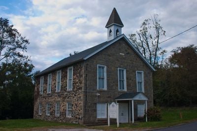
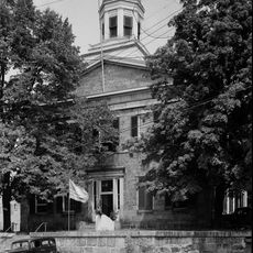
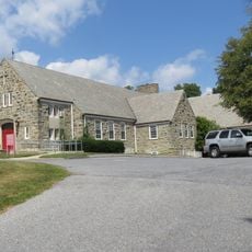
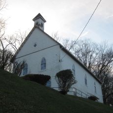
Mount Gilboa Chapel, African Methodist Episcopal Chapel in Oella, Maryland.

Description

Mount Gilboa Chapel is a stone building in Oella, Maryland that was constructed in 1859 and displays modest religious architecture from that era. The structure measures approximately 28 feet by 42 feet and features finely dressed stone on the front while the sides and rear use rougher stone construction.

History

Free African Americans built the chapel in 1859 to replace an earlier wooden structure where Benjamin Banneker may have worshipped. This site became a landmark of Black religious life in the region.

Culture

The chapel served as a spiritual center for the free Black community of Oella, fostering bonds through worship and shared faith. The cemetery nearby remains an active place of remembrance where descendants gather to honor their ancestors.

Practical

The chapel is protected as a historic site and the grounds are accessible for respectful visits that honor the location's significance. Visitors should approach the adjacent cemetery with care, as it contains burials spanning more than a century.

Did you know?

An obelisk erected in 1977 by the Maryland Bicentennial Commission stands in the cemetery to honor Benjamin Banneker, an esteemed Black mathematician and astronomer of the 1700s. The monument marks his likely burial place, though his original grave marker has been lost.

Location
GPS coordinates
39.27490,-76.77860
Latest update
December 14, 2025 18:20

AroundUs brings together thousands of curated places, local tips, and hidden gems, enriched daily by 60,000 contributors worldwide. Discover all places nearby (Maryland).

Around this place
Patapsco Valley State Park
United States of America

Patapsco Valley State Park

2.1 km
Ellicott City Historic District
United States of America

Ellicott City Historic District

1.7 km
Patterson Viaduct
United States of America

Patterson Viaduct

3.1 km
Ellicott City Station
United States of America

Ellicott City Station

1.6 km
Daniels Mill
United States of America

Daniels Mill

5.6 km
Hilton
United States of America

Hilton

4.6 km
Ellicott's Mills Historic District
United States of America

Ellicott's Mills Historic District

1.4 km
Lilburn
United States of America

Lilburn

1.9 km
Mt Ida
United States of America

Mt Ida

5.5 km
Howard County Courthouse
United States of America

Howard County Courthouse

1.8 km
White Hall
United States of America

White Hall

5.3 km
MacAlpine
United States of America

MacAlpine

4.4 km
Temora
United States of America

Temora

4.6 km
Old Catonsville Historic District
United States of America

Old Catonsville Historic District

3 km
Summit
United States of America

Summit

3.1 km
Elmonte
United States of America

Elmonte

5.3 km
Castle Thunder
United States of America

Castle Thunder

3.4 km
Bethesda
United States of America

Bethesda

3.7 km
St. John's Episcopal Church
United States of America

St. John's Episcopal Church

4.3 km
Winters Lane Historic District
United States of America

Winters Lane Historic District

3.2 km
Central Catonsville and Summit Park Historic District
United States of America

Central Catonsville and Summit Park Historic District

3.7 km
The Wilderness
United States of America

The Wilderness

2.2 km
St. Luke's African Methodist Episcopal Church
United States of America

St. Luke's African Methodist Episcopal Church

2.1 km
Howard County Circuit Courthouse
United States of America

Howard County Circuit Courthouse

1.9 km
Benjamin Banneker Historical Park and Museum
United States of America

Benjamin Banneker Historical Park and Museum

636 m
Linnwood
United States of America

Linnwood

4.3 km
Lower Elysville Bridge (1853)
United States of America

Lower Elysville Bridge (1853)

5.6 km
Lower Elysville Bridge (1868)
United States of America

Lower Elysville Bridge (1868)

5.6 km
Show the full map
« Mount Gilboa Chapel - African Methodist Episcopal Chapel in Oella, Maryland » is provided by Around Us (aroundus.com). Images and texts are derived from Wikimedia project under a Creative Commons license. You are allowed to copy, distribute, and modify copies of this page, under the conditions set by the license, as long as this note is clearly visible.

Discover hidden gems everywhere you go!

From secret cafés to breathtaking viewpoints, skip the crowded tourist spots and find places that match your style. Our app makes it easy with voice search, smart filtering, route optimization, and insider tips from travelers worldwide. Download now for the complete mobile experience.

Around Us App Screenshot

A unique approach to discovering new places

Le Figaro

All the places worth exploring

France Info

A tailor-made excursion in just a few clicks

20 Minutes

Around Us
Travel Guide & Maps
Download

Send to your phone

QR Code
1

Open the camera app on your mobile.

2

Point at the QR code with your camera. A notification will appear.

3

Tap the notification to open the link.