Enable Location

We need your location to show you interesting places around you

Discover nearby places

Find interesting locations and hidden gems around you

Precise directions

Get accurate directions and distances to places

Your location is never shared with other users. It's only used when you tap the location button.

Patterson Viaduct

Log in to your account

Start exploring — it's free

Trusted by 61,815 travelers worldwide

Continue with Google
Continue with Apple
or

We will send you a code to connect

By continuing, you accept our Terms and Conditions and our Privacy Policy

Check your inbox

We've sent a pincode in your inbox. Please enter the code below.

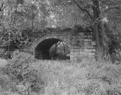
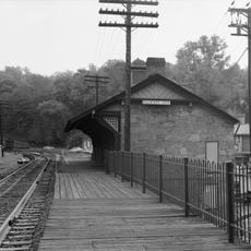
Patterson Viaduct, Railway bridge in Howard County and Baltimore County, Maryland, US

Description

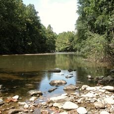
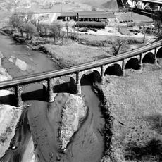
The Patterson Viaduct is a railroad bridge spanning the Patapsco River in Howard and Baltimore County, composed of four stone arches approximately 110 meters long. The structure displays the classical arch bridge design of the 1800s, with thick stone piers supporting a curved roadway.

History

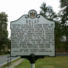
The viaduct was constructed between May and December 1829 as part of the Baltimore and Ohio Railroad's Old Main Line, marking early American railroad development. Following the 1868 flood that damaged the original structure, portions of the arch were incorporated into a new bridge design.

Culture

The structure is named after William Patterson, a B&O Railroad director, and demonstrates the construction techniques and stone materials typical of early American railroad infrastructure.

Practical

The site is accessible from the Grist Mill Trail, where visitors can cross the Patapsco River on a modern pedestrian pathway. The location requires care with uneven terrain and changing weather conditions, particularly during or after rain.

Did you know?

One of the original stone arches survived the 1868 flood and was later reused by engineer Wendel Bollman in an entirely new steel truss design. This unexpected transition from classical arch architecture to modern truss engineering is still visible at the site today.

Location
Location
Official opening
December 1829
Made from material
stone
GPS coordinates
39.24890,-76.76470
Latest update
December 12, 2025 07:59

AroundUs brings together thousands of curated places, local tips, and hidden gems, enriched daily by 60,000 contributors worldwide. Discover all places nearby (Howard County).

Around this place
Patapsco Valley State Park
United States of America

Patapsco Valley State Park

5.3 km
Thomas Viaduct
United States of America

Thomas Viaduct

5.4 km
Belmont Estate
United States of America

Belmont Estate

4.3 km
Ellicott City Historic District
United States of America

Ellicott City Historic District

3.5 km
Relay, Maryland
United States of America

Relay, Maryland

5.4 km
Ellicott City Station
United States of America

Ellicott City Station

3.3 km
Hilton
United States of America

Hilton

2.7 km
Center for Art, Design and Visual Culture
United States of America

Center for Art, Design and Visual Culture

4.5 km
UMBC Stadium
United States of America

UMBC Stadium

4.9 km
Ellicott's Mills Historic District
United States of America

Ellicott's Mills Historic District

3.2 km
Lilburn
United States of America

Lilburn

3.2 km
Hockley Forge and Mill
United States of America

Hockley Forge and Mill

5.4 km
Earl and Darielle Linehan Concert Hall
United States of America

Earl and Darielle Linehan Concert Hall

4.3 km
Howard County Courthouse
United States of America

Howard County Courthouse

3.6 km
Temora
United States of America

Temora

5.2 km
Old Catonsville Historic District
United States of America

Old Catonsville Historic District

3.1 km
Summit
United States of America

Summit

2.9 km
Castle Thunder
United States of America

Castle Thunder

3.2 km
Mount Gilboa Chapel
United States of America

Mount Gilboa Chapel

3.1 km
Curtis-Shipley Farmstead
United States of America

Curtis-Shipley Farmstead

4.9 km
Bethesda
United States of America

Bethesda

1.3 km
Winters Lane Historic District
United States of America

Winters Lane Historic District

3.9 km
Central Catonsville and Summit Park Historic District
United States of America

Central Catonsville and Summit Park Historic District

3.1 km
The Wilderness
United States of America

The Wilderness

987 m
St. Luke's African Methodist Episcopal Church
United States of America

St. Luke's African Methodist Episcopal Church

3.8 km
Howard County Circuit Courthouse
United States of America

Howard County Circuit Courthouse

3.6 km
Benjamin Banneker Historical Park and Museum
United States of America

Benjamin Banneker Historical Park and Museum

2.5 km
Lawyers Hill Historic District
United States of America

Lawyers Hill Historic District

4.3 km
Show the full map
« Patterson Viaduct - Railway bridge in Howard County and Baltimore County, Maryland, US » is provided by Around Us (aroundus.com). Images and texts are derived from Wikimedia project under a Creative Commons license. You are allowed to copy, distribute, and modify copies of this page, under the conditions set by the license, as long as this note is clearly visible.

Discover hidden gems everywhere you go!

From secret cafés to breathtaking viewpoints, skip the crowded tourist spots and find places that match your style. Our app makes it easy with voice search, smart filtering, route optimization, and insider tips from travelers worldwide. Download now for the complete mobile experience.

Around Us App Screenshot

A unique approach to discovering new places

Le Figaro

All the places worth exploring

France Info

A tailor-made excursion in just a few clicks

20 Minutes

Around Us
Travel Guide & Maps
Download

Send to your phone

QR Code
1

Open the camera app on your mobile.

2

Point at the QR code with your camera. A notification will appear.

3

Tap the notification to open the link.