Enable Location

We need your location to show you interesting places around you

Discover nearby places

Find interesting locations and hidden gems around you

Precise directions

Get accurate directions and distances to places

Your location is never shared with other users. It's only used when you tap the location button.

Thomas Viaduct

Log in to your account

Start exploring — it's free

Trusted by 62,870 travelers worldwide

Continue with Google
Continue with Apple
or

We will send you a code to connect

By continuing, you accept our Terms and Conditions and our Privacy Policy

Check your inbox

We've sent a pincode in your inbox. Please enter the code below.

Thomas Viaduct, Railway bridge in Elkridge, United States

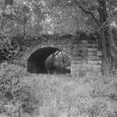
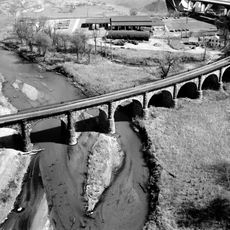
Thomas Viaduct is a stone railroad bridge spanning the Patapsco River with eight granite arches in a curved design between Relay and Elkridge. The structure continues to carry freight trains and MARC Camden Line commuter trains today.

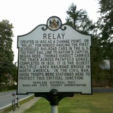
The Baltimore and Ohio Railroad built this stone bridge between 1833 and 1835, creating the first multi-span masonry railway bridge in the United States. This structure marked a turning point in American railroad infrastructure.

An obelisk at the eastern end displays the names of railroad directors, engineers, and builders who created this structure. These inscriptions preserve the memory of the people behind this engineering achievement.

The viaduct is best viewed from nearby roads where visitors can see the arches and overall structure clearly. Morning or late afternoon light works well for photographs of the stone surfaces.

The structure survived the great flood of 1868 and Hurricane Agnes in 1972 with barely a scratch, while most surrounding buildings in the Patapsco Valley were destroyed. This resilience showed that the stone arch construction was exceptionally sound.

The community of curious travelers

AroundUs brings together thousands of curated places, local tips, and hidden gems, enriched daily by 60,000 contributors worldwide.

Start exploring
Location
Location
Inception
1835
Made from material
stone
GPS coordinates
39.22170,-76.71330
Latest update
December 7, 2025 20:46
Around this place
Belmont Estate
United States of America

Belmont Estate

1.6 km
National Electronics Museum
United States of America

National Electronics Museum

3.8 km
St. Charles College, Maryland
United States of America

St. Charles College, Maryland

5.3 km
Relay, Maryland
United States of America

Relay, Maryland

333 m
Patterson Viaduct
United States of America

Patterson Viaduct

5.4 km
Elkridge Furnace Complex
United States of America

Elkridge Furnace Complex

1.3 km
Hilton
United States of America

Hilton

3.9 km
Arbutus Oak
United States of America

Arbutus Oak

4.2 km
Benson-Hammond House
United States of America

Benson-Hammond House

6.2 km
Troy
United States of America

Troy

5.1 km
Center for Art, Design and Visual Culture
United States of America

Center for Art, Design and Visual Culture

3.7 km
UMBC Stadium
United States of America

UMBC Stadium

3.2 km
Hockley Forge and Mill
United States of America

Hockley Forge and Mill

117 m
Earl and Darielle Linehan Concert Hall
United States of America

Earl and Darielle Linehan Concert Hall

3.8 km
Trinity Church
United States of America

Trinity Church

6.8 km
Old Catonsville Historic District
United States of America

Old Catonsville Historic District

6.2 km
Summit
United States of America

Summit

5.8 km
Castle Thunder
United States of America

Castle Thunder

5.9 km
Weiskittel-Roehle Burial Vault
United States of America

Weiskittel-Roehle Burial Vault

7 km
Bethesda
United States of America

Bethesda

4.5 km
Turkey Hill
United States of America

Turkey Hill

5.4 km
Lansdowne Christian Church
United States of America

Lansdowne Christian Church

5 km
Winters Lane Historic District
United States of America

Winters Lane Historic District

6.9 km
Central Catonsville and Summit Park Historic District
United States of America

Central Catonsville and Summit Park Historic District

5.4 km
The Wilderness
United States of America

The Wilderness

6.1 km
Sunnyfields
United States of America

Sunnyfields

7 km
Old Catonsville High School
United States of America

Old Catonsville High School

6 km
Linthicum Heights Historic District
United States of America

Linthicum Heights Historic District

5.3 km
Show the full map
« Thomas Viaduct - Railway bridge in Elkridge, United States » is provided by Around Us (aroundus.com). Images and texts are derived from Wikimedia project under a Creative Commons license. You are allowed to copy, distribute, and modify copies of this page, under the conditions set by the license, as long as this note is clearly visible.

Discover hidden gems everywhere you go!

From secret cafés to breathtaking viewpoints, skip the crowded tourist spots and find places that match your style. Our app makes it easy with voice search, smart filtering, route optimization, and insider tips from travelers worldwide. Download now for the complete mobile experience.

Around Us App Screenshot

A unique approach to discovering new places

Le Figaro

All the places worth exploring

France Info

A tailor-made excursion in just a few clicks

20 Minutes

Around Us
Travel Guide & Maps
Download

Send to your phone

QR Code
1

Open the camera app on your mobile.

2

Point at the QR code with your camera. A notification will appear.

3

Tap the notification to open the link.