Enable Location

We need your location to show you interesting places around you

Discover nearby places

Find interesting locations and hidden gems around you

Precise directions

Get accurate directions and distances to places

Your location is never shared with other users. It's only used when you tap the location button.

Musselbed Shoals Light

Log in to your account

Start exploring — it's free

Trusted by 62,908 travelers worldwide

Continue with Google
Continue with Apple
or

We will send you a code to connect

By continuing, you accept our Terms and Conditions and our Privacy Policy

Check your inbox

We've sent a pincode in your inbox. Please enter the code below.

Musselbed Shoals Light
Discussion Reviews 1 Photos
1.4k Popularity

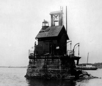
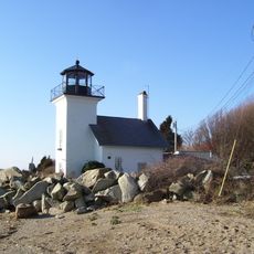
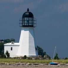
Musselbed Shoals Light, Lighthouse in Narragansett Bay, Rhode Island, United States.

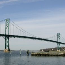
Musselbed Shoals Light is a 6-meter tall skeleton tower marking the entrance to Mount Hope Bay where shifting currents and sandbars create navigation hazards. The automated beacon guides vessels safely through the narrow channels in this busy shipping corridor.

The original lighthouse was built in 1873 as maritime traffic increased along the East Coast. A major hurricane in 1938 damaged the structure so severely that it was replaced with the current skeletal tower design.

The light represents Rhode Island's long connection to the sea and the importance of safe passage through these waters. It stands as a reminder of how local communities have depended on such beacons to protect maritime life.

The light stands in shallow waters of Narragansett Bay and is best viewed from a boat or the shoreline of nearby beaches. Visitors should plan to see it from the water or from coastal viewpoints rather than expect ground-level access.

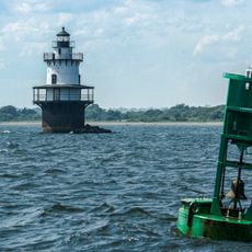
The skeleton tower design with its open lattice structure was an engineering innovation that reduced material costs and wind resistance compared to traditional solid towers. This efficient style became widely adopted for coastal lights built in the later 1900s.

The community of curious travelers

AroundUs brings together thousands of curated places, local tips, and hidden gems, enriched daily by 60,000 contributors worldwide.

Start exploring
Location
Inception
1873
Height
6 m
GPS coordinates
41.63628,-71.25992
Latest update
December 14, 2025 16:44
Around this place
Portsmouth Abbey School
United States of America

Portsmouth Abbey School

3.8 km
Mount Hope Bridge
United States of America

Mount Hope Bridge

426 m
Colt State Park
United States of America

Colt State Park

5.5 km
Blithewold Mansion, Gardens and Arboretum
United States of America

Blithewold Mansion, Gardens and Arboretum

2.1 km
Green Animals Topiary Garden
United States of America

Green Animals Topiary Garden

4.2 km
Sakonnet River Bridge
United States of America

Sakonnet River Bridge

3.9 km
William G. Low House
United States of America

William G. Low House

1.3 km
Mount Hope Farm
United States of America

Mount Hope Farm

5.1 km
Herreshoff Marine Museum
United States of America

Herreshoff Marine Museum

3.2 km
Battle of Rhode Island Site
United States of America

Battle of Rhode Island Site

4.5 km
Bristol County Jail
United States of America

Bristol County Jail

3.9 km
Stone Bridge
United States of America

Stone Bridge

3.7 km
Musée Patamécanique
United States of America

Musée Patamécanique

3.9 km
Portsmouth Abbey
United States of America

Portsmouth Abbey

3.8 km
Bristol Ferry Light
United States of America

Bristol Ferry Light

732 m
Sakonnet River Rail Bridge
United States of America

Sakonnet River Rail Bridge

3.9 km
Prudence Island Light
United States of America

Prudence Island Light

5 km
Bourne Mill
United States of America

Bourne Mill

7.8 km
Coggeshall Farm Museum
United States of America

Coggeshall Farm Museum

5.1 km
Hog Island Shoal Light
United States of America

Hog Island Shoal Light

1.2 km
Benjamin Church House
United States of America

Benjamin Church House

5.7 km
Bristol County Courthouse
United States of America

Bristol County Courthouse

3.2 km
Borden Farm
United States of America

Borden Farm

3.3 km
Bristol Waterfront Historic District
United States of America

Bristol Waterfront Historic District

3.8 km
Poppasquash Farms Historic District
United States of America

Poppasquash Farms Historic District

5.6 km
Benjamin Barker House
United States of America

Benjamin Barker House

4.6 km
Osborn-Bennett Historic District
United States of America

Osborn-Bennett Historic District

5.2 km
Joseph Reynolds House
United States of America

Joseph Reynolds House

5.5 km
Show the full map
Reviews
Share your experience

No review yet

Discussions
Start a discussion...

No discussion yet

« Musselbed Shoals Light - Lighthouse in Narragansett Bay, Rhode Island, United States » is provided by Around Us (aroundus.com). Images and texts are derived from Wikimedia project under a Creative Commons license. You are allowed to copy, distribute, and modify copies of this page, under the conditions set by the license, as long as this note is clearly visible.

Discover hidden gems everywhere you go!

From secret cafés to breathtaking viewpoints, skip the crowded tourist spots and find places that match your style. Our app makes it easy with voice search, smart filtering, route optimization, and insider tips from travelers worldwide. Download now for the complete mobile experience.

Around Us App Screenshot

A unique approach to discovering new places

Le Figaro

All the places worth exploring

France Info

A tailor-made excursion in just a few clicks

20 Minutes

Around Us
Travel Guide & Maps
Download

Send to your phone

QR Code
1

Open the camera app on your mobile.

2

Point at the QR code with your camera. A notification will appear.

3

Tap the notification to open the link.