Enable Location

We need your location to show you interesting places around you

Discover nearby places

Find interesting locations and hidden gems around you

Precise directions

Get accurate directions and distances to places

Your location is never shared with other users. It's only used when you tap the location button.

Mount Kisco Municipal Complex

Log in to your account

Start exploring — it's free

Trusted by 63,004 travelers worldwide

Continue with Google
Continue with Apple
or

We will send you a code to connect

By continuing, you accept our Terms and Conditions and our Privacy Policy

Check your inbox

We've sent a pincode in your inbox. Please enter the code below.

Discussion Reviews 1 Photos
1.3k Popularity

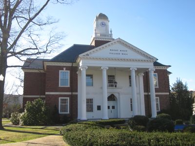
Mount Kisco Municipal Complex, Municipal complex in Mount Kisco, United States.

Mount Kisco Municipal Complex is a two-story brick building with an octagonal clock tower and a limestone base topped by slate roofs. It houses town offices, administrative departments, and public services for residents to conduct official business.

The building was designed in 1932 by architects Mott B. Schmidt and O'Brien & Klikel and gained National Register status in 1997. Its construction reflected the city's decision to consolidate government operations into one dedicated structure during that era.

The post office section inside holds murals painted in the 1930s by artist Thomas Donnelly that show Mount Kisco's growth through visual stories. These artworks remain part of how locals and visitors experience the building's interior.

The complex is accessible during business hours for visitors needing to conduct official business or view the building. Parking is available on-site, and signage helps guide people to the appropriate offices.

The building follows a cruciform floor plan with symmetrical wings extending from a central section, an uncommon layout for a government office. This design creates interesting spatial flow as visitors move through the interconnected areas.

The community of curious travelers

AroundUs brings together thousands of curated places, local tips, and hidden gems, enriched daily by 60,000 contributors worldwide.

Start exploring
Location
GPS coordinates
41.20250,-73.72694
Latest update
December 14, 2025 17:40
Around this place
Sol Friedman House
United States of America

Sol Friedman House

8.4 km
Stepping Stones
United States of America

Stepping Stones

5.4 km
Caramoor Center for Music and the Arts
United States of America

Caramoor Center for Music and the Arts

7.8 km
Edward Serlin House
United States of America

Edward Serlin House

8.6 km
Site of Old Croton Dam
United States of America

Site of Old Croton Dam

7.1 km
United States of America

Lasdon Park and Arboretum

8.2 km
Bedford Village Historic District
United States of America

Bedford Village Historic District

7 km
Rehoboth
United States of America

Rehoboth

6.3 km
Smith Tavern
United States of America

Smith Tavern

8.9 km
Greeley House
United States of America

Greeley House

6.1 km
Richard H. Mandel House
United States of America

Richard H. Mandel House

4.7 km
Carrie Chapman Catt House
United States of America

Carrie Chapman Catt House

8 km
Old Chappaqua Historic District
United States of America

Old Chappaqua Historic District

5.3 km
Merestead
United States of America

Merestead

3.5 km
Bedford Road Historic District
United States of America

Bedford Road Historic District

8.7 km
Church of Saint Mary the Virgin
United States of America

Church of Saint Mary the Virgin

6.5 km
The Woodpile
United States of America

The Woodpile

2.9 km
Isaac Young House
United States of America

Isaac Young House

7.6 km
St. Mark's Episcopal Church
United States of America

St. Mark's Episcopal Church

528 m
Williams–DuBois House
United States of America

Williams–DuBois House

8.6 km
United Methodist Church and Parsonage
United States of America

United Methodist Church and Parsonage

282 m
Witthoefft House
United States of America

Witthoefft House

8.1 km
Katonah Village Historic District
United States of America

Katonah Village Historic District

6.9 km
Stonecrest
United States of America

Stonecrest

2.6 km
Katonah Museum of Art
United States of America

Katonah Museum of Art

8.1 km
Stepping Stones - Historic Home of Bill and Lois Wilson
United States of America

Stepping Stones - Historic Home of Bill and Lois Wilson

5.4 km
John Jay Homestead State Historic Site
United States of America

John Jay Homestead State Historic Site

7.8 km
Muscoot Reservoir
United States of America

Muscoot Reservoir

7.6 km
Show the full map
Reviews
Share your experience

No review yet

Discussions
Start a discussion...

No discussion yet

« Mount Kisco Municipal Complex - Municipal complex in Mount Kisco, United States » is provided by Around Us (aroundus.com). Images and texts are derived from Wikimedia project under a Creative Commons license. You are allowed to copy, distribute, and modify copies of this page, under the conditions set by the license, as long as this note is clearly visible.

Discover hidden gems everywhere you go!

From secret cafés to breathtaking viewpoints, skip the crowded tourist spots and find places that match your style. Our app makes it easy with voice search, smart filtering, route optimization, and insider tips from travelers worldwide. Download now for the complete mobile experience.

Around Us App Screenshot

A unique approach to discovering new places

Le Figaro

All the places worth exploring

France Info

A tailor-made excursion in just a few clicks

20 Minutes

Around Us
Travel Guide & Maps
Download

Send to your phone

QR Code
1

Open the camera app on your mobile.

2

Point at the QR code with your camera. A notification will appear.

3

Tap the notification to open the link.