Enable Location

We need your location to show you interesting places around you

Discover nearby places

Find interesting locations and hidden gems around you

Precise directions

Get accurate directions and distances to places

Your location is never shared with other users. It's only used when you tap the location button.

Smith Tavern

Log in to your account

Start exploring — it's free

Trusted by 62,178 travelers worldwide

Continue with Google
Continue with Apple
or

We will send you a code to connect

By continuing, you accept our Terms and Conditions and our Privacy Policy

Check your inbox

We've sent a pincode in your inbox. Please enter the code below.

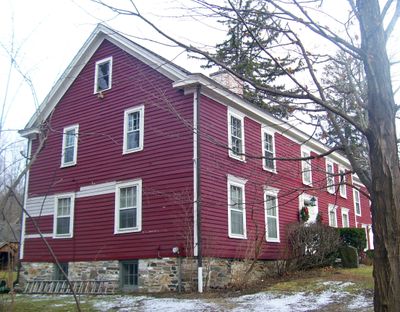
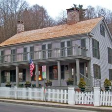
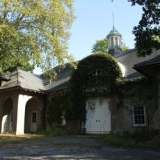
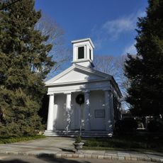
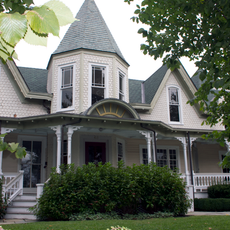
Smith Tavern, Revolutionary War-era tavern in Armonk, New York, US

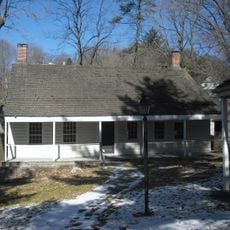
Smith Tavern is a historic building in Armonk featuring clapboard siding, a stone foundation, and multiple rooms that once housed travelers moving between New York City and Danbury. The property sits along a major travel route and functioned as a stopping point for people journeying between these two important centers.

The building was constructed in the late 18th century and served as militia headquarters during the Revolutionary War. After the conflict, it transformed into a stagecoach station that connected a growing region with improved transportation links.

The tavern was named after John Smith, a Continental Army officer who later used it as a gathering place for community discussions. The rooms reflect how citizens once met to address local matters together.

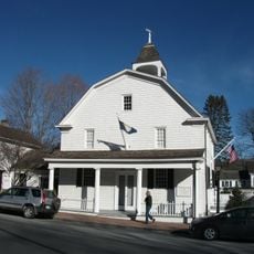
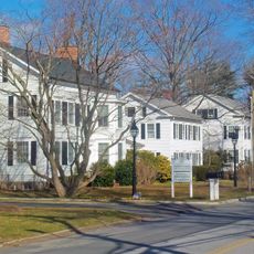
The building is now part of a complex operated by the North Castle Historical Society that displays several historic structures side by side. Visitors should prepare for limited opening hours and check in advance, as this is a maintained historical site rather than a continuously open museum.

When John Smith purchased the property in 1797, he established a post office inside and used the space for public gatherings and debates. This dual function as both a mail hub and a meeting place made it a vital center for information and civic discussion in the area.

The community of curious travelers

AroundUs brings together thousands of curated places, local tips, and hidden gems, enriched daily by 60,000 contributors worldwide.

Start exploring
Location
GPS coordinates
41.12611,-73.69389
Latest update
December 12, 2025 17:48
Around this place
Kensico Reservoir
United States of America

Kensico Reservoir

7.4 km
Sol Friedman House
United States of America

Sol Friedman House

4.5 km
Roland Reisley House
United States of America

Roland Reisley House

4.3 km
Jacob Burns Film Center
United States of America

Jacob Burns Film Center

8.3 km
Neuberger Museum of Art
United States of America

Neuberger Museum of Art

8.7 km
Mianus River Gorge
United States of America

Mianus River Gorge

9 km
Elijah Miller House
United States of America

Elijah Miller House

9.9 km
Edward Serlin House
United States of America

Edward Serlin House

4.4 km
Greenwich Polo Club
United States of America

Greenwich Polo Club

5.5 km
Bedford Village Historic District
United States of America

Bedford Village Historic District

9.6 km
Rehoboth
United States of America

Rehoboth

7.1 km
Greeley House
United States of America

Greeley House

7.4 km
Round Hill Historic District
United States of America

Round Hill Historic District

3.1 km
Old Chappaqua Historic District
United States of America

Old Chappaqua Historic District

8.7 km
Merestead
United States of America

Merestead

5.6 km
Bedford Road Historic District
United States of America

Bedford Road Historic District

1.6 km
Church of Saint Mary the Virgin
United States of America

Church of Saint Mary the Virgin

7.4 km
Nathaniel Witherell Historic District
United States of America

Nathaniel Witherell Historic District

9.1 km
Long Ridge Village Historic District
United States of America

Long Ridge Village Historic District

9 km
Sylvanus Selleck Gristmill
United States of America

Sylvanus Selleck Gristmill

4.8 km
Mount Kisco Municipal Complex
United States of America

Mount Kisco Municipal Complex

8.9 km
St. Mark's Episcopal Church
United States of America

St. Mark's Episcopal Church

9.4 km
French Farm
United States of America

French Farm

9.4 km
United Methodist Church and Parsonage
United States of America

United Methodist Church and Parsonage

8.7 km
Witthoefft House
United States of America

Witthoefft House

3.6 km
Graham House
United States of America

Graham House

8 km
Marmaduke Forster House
United States of America

Marmaduke Forster House

8.1 km
Reclining Figure
United States of America

Reclining Figure

10.1 km
Show the full map
« Smith Tavern - Revolutionary War-era tavern in Armonk, New York, US » is provided by Around Us (aroundus.com). Images and texts are derived from Wikimedia project under a Creative Commons license. You are allowed to copy, distribute, and modify copies of this page, under the conditions set by the license, as long as this note is clearly visible.

Discover hidden gems everywhere you go!

From secret cafés to breathtaking viewpoints, skip the crowded tourist spots and find places that match your style. Our app makes it easy with voice search, smart filtering, route optimization, and insider tips from travelers worldwide. Download now for the complete mobile experience.

Around Us App Screenshot

A unique approach to discovering new places

Le Figaro

All the places worth exploring

France Info

A tailor-made excursion in just a few clicks

20 Minutes

Around Us
Travel Guide & Maps
Download

Send to your phone

QR Code
1

Open the camera app on your mobile.

2

Point at the QR code with your camera. A notification will appear.

3

Tap the notification to open the link.