Niobrara Formation

Log in to your account

AroundUs is a community-driven map of interesting places, built by curious explorers like you. It grows with every review, story, and photo you share.
Connect to save your favorite spots, contribute locations, and create personalized routes.
By continuing, you accept our Terms and Conditions and our Privacy Policy

Niobrara Formation

Add to collection
Map
Suggest a change
Share

Niobrara Formation, Geological formation in Great Plains region, United States.
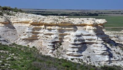
The Niobrara Formation contains two principal components: the Smoky Hill Chalk Member and the Fort Hays Limestone Member, extending across multiple states.

Scientists Meek and Hayden formally named the formation in 1862, following initial exploration efforts that began in 1857 across the region.

Native American tribes utilized the formation's Smoky Hill Jasper, a silicified material beneath Ogallala sediments, for manufacturing tools and implements.

The formation serves as a source of natural gas extraction in the eastern Denver Basin through specific drilling and fracturing methods.

Marine fossils within the chalk layers reveal the existence of mosasaurs, plesiosaurs, and primitive birds from the Late Cretaceous period.

Location: Minnesota

Location: Montana

Made from material: chalk

GPS coordinates: 42.74691,-98.03980

Latest update: May 27, 2025 13:20

Around this place
Show the full map
Ashfall Fossil Beds
United States of America

Ashfall Fossil Beds

37.1 km
Lewis and Clark Lake
United States of America

Lewis and Clark Lake

47.2 km
Niobrara State Park
United States of America

Niobrara State Park

1.6 km
Chief Standing Bear Memorial Bridge
United States of America

Chief Standing Bear Memorial Bridge

4.9 km
Lewis and Clark State Recreation Area
United States of America

Lewis and Clark State Recreation Area

39 km
Calumet Bluff
United States of America

Calumet Bluff

47.1 km
Z.C.B.J. Opera House
United States of America

Z.C.B.J. Opera House

16.7 km
St. Wenceslaus Catholic Church and Parish House
United States of America

St. Wenceslaus Catholic Church and Parish House

38.5 km
Gavins Point National Fish Hatchery
United States of America

Gavins Point National Fish Hatchery

47.9 km
St. Rose of Lima Catholic Church and School Complex
United States of America

St. Rose of Lima Catholic Church and School Complex

44.1 km
Niobrara River Bridge
United States of America

Niobrara River Bridge

2.3 km
Congregational Church and Manse
United States of America

Congregational Church and Manse

18.8 km
Training Dike Recreation Area
United States of America

Training Dike Recreation Area

47.8 km
Church of Our Most Merciful Saviour
United States of America

Church of Our Most Merciful Saviour

19.5 km
Old St. Wenceslaus Catholic Parish House
United States of America

Old St. Wenceslaus Catholic Parish House

38.4 km
Knox County Courthouse
United States of America

Knox County Courthouse

20.3 km
Cottonwood Recreation Area
United States of America

Cottonwood Recreation Area

47.3 km
Rad Sladkovsky
United States of America

Rad Sladkovsky

14.2 km
Rouse Ranch
United States of America

Rouse Ranch

46.1 km
ZCBJ Hall
United States of America

ZCBJ Hall

31.1 km
Verdigris Creek Bridge
United States of America

Verdigris Creek Bridge

43.6 km
Bon Homme County Courthouse
United States of America

Bon Homme County Courthouse

30.9 km
Ponca Tribal Self-Help Community Building Historic District
United States of America

Ponca Tribal Self-Help Community Building Historic District

5.3 km
John Frydrych Farmstead
United States of America

John Frydrych Farmstead

33.6 km
Mathias Merkwan Rubblestone Barn
United States of America

Mathias Merkwan Rubblestone Barn

40.2 km
Wagner House
United States of America

Wagner House

40.2 km
Bazile Creek Bridge
United States of America

Bazile Creek Bridge

20.3 km
Gross State Aid Bridge
United States of America

Gross State Aid Bridge

10.3 km
Show the full map

Reviews

Visited this place? Tap the stars to rate it and share your experience / photos with the community! Try now! You can cancel it anytime.

« Niobrara Formation: Geological formation in Great Plains region, United States » is provided by Around Us (aroundus.com). Images and texts are derived from Wikimedia project under a Creative Commons license. You are allowed to copy, distribute, and modify copies of this page, under the conditions set by the license, as long as this note is clearly visible.

Discover hidden gems everywhere you go!

From secret cafés to breathtaking viewpoints, skip the crowded tourist spots and find places that match your style. Our app makes it easy with voice search, smart filtering, route optimization, and insider tips from travelers worldwide. Download now for the complete mobile experience.

Around Us App Screenshot

A unique approach to discovering new places

Le Figaro

All the places worth exploring

France Info

A tailor-made excursion in just a few clicks

20 Minutes