Chief Standing Bear Memorial Bridge

Log in to your account

AroundUs is a community-driven map of interesting places, built by curious explorers like you. It grows with every review, story, and photo you share.
Connect to save your favorite spots, contribute locations, and create personalized routes.
By continuing, you accept our Terms and Conditions and our Privacy Policy

Chief Standing Bear Memorial Bridge

Add to collection
Map
Suggest a change
Share

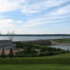
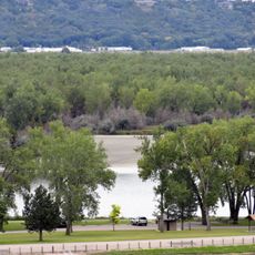
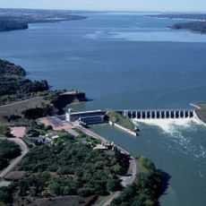
Chief Standing Bear Memorial Bridge, Road bridge across Missouri River between Niobrara, Nebraska and South Dakota, United States

The Chief Standing Bear Memorial Bridge extends 2,953 feet across the Missouri River, connecting Nebraska Highway 14 with South Dakota Highway 37.

The bridge, completed in 1998, replaced a ferry service that operated until 1984, fulfilling a long-standing need for a permanent river crossing in the region.

The bridge honors Chief Standing Bear, a Ponca leader who fought for Native American rights in a landmark 1879 federal court case.

Federal funding covered the majority of the 17 million dollar construction cost, providing a crucial transportation link between Nebraska and South Dakota.

During the 2011 Missouri River floods, residents near the Nebraska side created alternative transport methods when the bridge became temporarily inaccessible.

Location: Nebraska

Location: South Dakota

GPS coordinates: 42.77000,-97.98940

Latest update: November 28, 2025 14:29

Around this place
Show the full map
Ashfall Fossil Beds
United States of America

Ashfall Fossil Beds

40.8 km
Niobrara Formation
United States of America

Niobrara Formation

4.9 km
Lewis and Clark Lake
United States of America

Lewis and Clark Lake

42.7 km
Niobrara State Park
United States of America

Niobrara State Park

6.5 km
Lewis and Clark State Recreation Area
United States of America

Lewis and Clark State Recreation Area

34.4 km
Calumet Bluff
United States of America

Calumet Bluff

42.4 km
Z.C.B.J. Opera House
United States of America

Z.C.B.J. Opera House

19.6 km
St. Wenceslaus Catholic Church and Parish House
United States of America

St. Wenceslaus Catholic Church and Parish House

33.7 km
Gavins Point National Fish Hatchery
United States of America

Gavins Point National Fish Hatchery

43.3 km
St. Rose of Lima Catholic Church and School Complex
United States of America

St. Rose of Lima Catholic Church and School Complex

40.2 km
Niobrara River Bridge
United States of America

Niobrara River Bridge

4.9 km
Congregational Church and Manse
United States of America

Congregational Church and Manse

14 km
Training Dike Recreation Area
United States of America

Training Dike Recreation Area

43.2 km
Church of Our Most Merciful Saviour
United States of America

Church of Our Most Merciful Saviour

14.7 km
Old St. Wenceslaus Catholic Parish House
United States of America

Old St. Wenceslaus Catholic Parish House

33.6 km
Knox County Courthouse
United States of America

Knox County Courthouse

20.2 km
Cottonwood Recreation Area
United States of America

Cottonwood Recreation Area

42.6 km
Rad Sladkovsky
United States of America

Rad Sladkovsky

18.8 km
ZCBJ Hall
United States of America

ZCBJ Hall

27 km
Verdigris Creek Bridge
United States of America

Verdigris Creek Bridge

46.8 km
Bon Homme County Courthouse
United States of America

Bon Homme County Courthouse

26.9 km
Ponca Tribal Self-Help Community Building Historic District
United States of America

Ponca Tribal Self-Help Community Building Historic District

10.1 km
John Frydrych Farmstead
United States of America

John Frydrych Farmstead

29 km
Mathias Merkwan Rubblestone Barn
United States of America

Mathias Merkwan Rubblestone Barn

35.4 km
DeJong House
United States of America

DeJong House

46.4 km
Wagner House
United States of America

Wagner House

39 km
Bazile Creek Bridge
United States of America

Bazile Creek Bridge

20.2 km
Gross State Aid Bridge
United States of America

Gross State Aid Bridge

13.6 km
Show the full map

Reviews

Visited this place? Tap the stars to rate it and share your experience / photos with the community! Try now! You can cancel it anytime.

« Chief Standing Bear Memorial Bridge - Road bridge across Missouri River between Niobrara, Nebraska and South Dakota, United States » is provided by Around Us (aroundus.com). Images and texts are derived from Wikimedia project under a Creative Commons license. You are allowed to copy, distribute, and modify copies of this page, under the conditions set by the license, as long as this note is clearly visible.

Discover hidden gems everywhere you go!

From secret cafés to breathtaking viewpoints, skip the crowded tourist spots and find places that match your style. Our app makes it easy with voice search, smart filtering, route optimization, and insider tips from travelers worldwide. Download now for the complete mobile experience.

Around Us App Screenshot

A unique approach to discovering new places

Le Figaro

All the places worth exploring

France Info

A tailor-made excursion in just a few clicks

20 Minutes