Lewis and Clark Lake

Log in to your account

AroundUs is a community-driven map of interesting places, built by curious explorers like you. It grows with every review, story, and photo you share.
Connect to save your favorite spots, contribute locations, and create personalized routes.
By continuing, you accept our Terms and Conditions and our Privacy Policy

Lewis and Clark Lake

Add to collection
Map
Suggest a change
Share

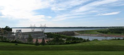
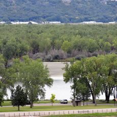
Lewis and Clark Lake, Reservoir on Missouri River between South Dakota and Nebraska, United States.

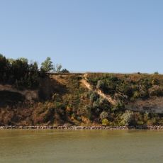
Lewis and Clark Lake is a reservoir formed by damming the Missouri River between South Dakota and Nebraska, creating a long body of water with varied shoreline features. The water is surrounded by rolling terrain, sandy banks, and wooded areas that change as you move along the shoreline.

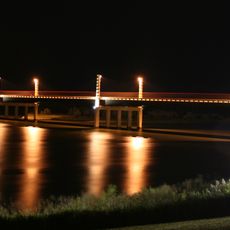
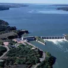
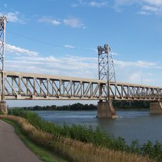
The Army Corps of Engineers built Gavins Point Dam across the Missouri River in 1957, creating this reservoir where a flowing river once existed. The construction marked a major change to the landscape and hydrology of the region.

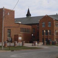
The Lewis and Clark Visitor Center atop Calumet Bluff presents exhibits about Missouri River Basin history and regional wildlife populations.

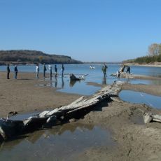
You can access the lake at multiple public areas along both shores where boat ramps and parking are available. Spring through fall offers the most comfortable weather and full access to all recreation areas.

The lake gradually loses water storage capacity each year as sediment from upstream areas settles on the bottom. This slow filling process is a quiet reminder of how nature continuously reshapes reservoirs over time.

Location: South Dakota

Location: Nebraska

GPS coordinates: 42.86250,-97.49170

Latest update: December 8, 2025 19:54

Photos
Around this place
Yankton College
United States of America

Yankton College

8.6 km
Missouri National Recreational River
United States of America

Missouri National Recreational River

8.1 km
Human Services Center
United States of America

Human Services Center

7.8 km
Discovery Bridge
United States of America

Discovery Bridge

7.7 km
Lewis and Clark State Recreation Area
United States of America

Lewis and Clark State Recreation Area

7.6 km
Calumet Bluff
United States of America

Calumet Bluff

551 m
Argo Hotel
United States of America

Argo Hotel

14.6 km
St. Rose of Lima Catholic Church and School Complex
United States of America

St. Rose of Lima Catholic Church and School Complex

14.9 km
Gavins Point National Fish Hatchery
United States of America

Gavins Point National Fish Hatchery

1.4 km
Governor John L. Pennington House
United States of America

Governor John L. Pennington House

8.7 km
Training Dike Recreation Area
United States of America

Training Dike Recreation Area

1.9 km
United Church of Christ
United States of America

United Church of Christ

18.6 km
Cottonwood Recreation Area
United States of America

Cottonwood Recreation Area

778 m
Ohlman-Shannon House
United States of America

Ohlman-Shannon House

7.4 km
St. Boniface Catholic Church Complex
United States of America

St. Boniface Catholic Church Complex

12.9 km
Yankton Carnegie Library
United States of America

Yankton Carnegie Library

8.3 km
Van Osdel House
United States of America

Van Osdel House

18.4 km
William J. Fantle House
United States of America

William J. Fantle House

8.4 km
Harold A. Doyle House
United States of America

Harold A. Doyle House

7.4 km
Burns House
United States of America

Burns House

8.6 km
Dr. John Trierweiler House
United States of America

Dr. John Trierweiler House

7.2 km
Bishop Marty Rectory
United States of America

Bishop Marty Rectory

6.9 km
Dr. B.M. Banton House
United States of America

Dr. B.M. Banton House

7.6 km
Bruce-Donaldson House
United States of America

Bruce-Donaldson House

8.4 km
Mathias Merkwan Rubblestone Barn
United States of America

Mathias Merkwan Rubblestone Barn

15.1 km
Fred Schnauber House
United States of America

Fred Schnauber House

8.1 km
DeJong House
United States of America

DeJong House

13.2 km
Meridian Highway Bridge
United States of America

Meridian Highway Bridge

8 km
Show the full map
Reviews

Visited this place? Tap the stars to rate it and share your experience / photos with the community! Try now! You can cancel it anytime.

« Lewis and Clark Lake - Reservoir on Missouri River between South Dakota and Nebraska, United States » is provided by Around Us (aroundus.com). Images and texts are derived from Wikimedia project under a Creative Commons license. You are allowed to copy, distribute, and modify copies of this page, under the conditions set by the license, as long as this note is clearly visible.

Discover hidden gems everywhere you go!

From secret cafés to breathtaking viewpoints, skip the crowded tourist spots and find places that match your style. Our app makes it easy with voice search, smart filtering, route optimization, and insider tips from travelers worldwide. Download now for the complete mobile experience.

Around Us App Screenshot

A unique approach to discovering new places

Le Figaro

All the places worth exploring

France Info

A tailor-made excursion in just a few clicks

20 Minutes