Missouri National Recreational River

Log in to your account

AroundUs is a community-driven map of interesting places, built by curious explorers like you. It grows with every review, story, and photo you share.
Connect to save your favorite spots, contribute locations, and create personalized routes.
Continue with Google
Continue with Apple
Continue with X
Continue with Facebook
Continue with email
By continuing, you accept our Terms and Conditions and our Privacy Policy
Create an account
Add to collection
Map
Suggest a change
Share

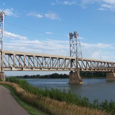
Missouri National Recreational River, Protected river section in Nebraska and South Dakota, United States.

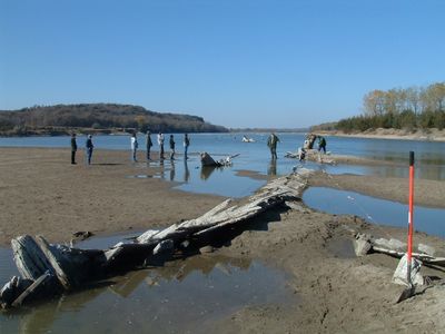
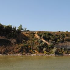
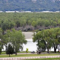
Missouri National Recreational River is a protected waterway spanning roughly 100 miles across Nebraska and South Dakota, preserving sections that flow naturally without dams. These river segments support diverse plant and animal habitats along their banks and in the water.

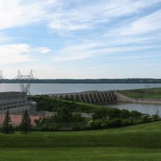
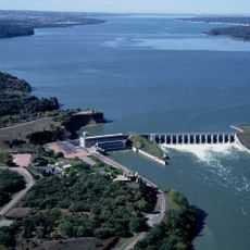
Protection came in two stages: first in 1978 when one section was designated, then years later when additional miles were added to the program. This gradual protection safeguarded the final free-flowing parts of this major river system.

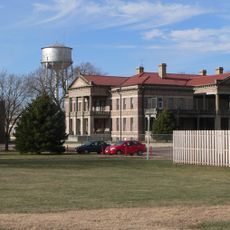
The riverbanks show traces of long-term human settlement patterns, reflecting the waterway's importance to people in the region over many centuries. Today visitors notice how the landscape retains a natural character that connects to this deep history.

Access points include state parks and visitor centers along the protected sections, offering different entry locations depending on which area you wish to explore. Plan visits during stable weather when water levels are predictable and shoreline trails remain passable.

These sections represent some of the final stretches where the lower Missouri flows completely free from dams and artificial channeling between its upper reaches and the mouth. This rarity makes them a striking example of how the river once moved naturally.

Location: Nebraska

Location: South Dakota

Inception: 1978

Website: https://nps.gov/mnrr

GPS coordinates: 42.86250,-97.39278

Latest update: December 9, 2025 18:48

Photos
Around this place
Lewis and Clark Lake
United States of America

Lewis and Clark Lake

8.1 km
Human Services Center
United States of America

Human Services Center

6.4 km
Discovery Bridge
United States of America

Discovery Bridge

450 m
United States of America

Lewis and Clark State Recreation Area

15.4 km
Calumet Bluff
United States of America

Calumet Bluff

7.5 km
Immaculate Conception Catholic Church and Rectory
United States of America

Immaculate Conception Catholic Church and Rectory

13.2 km
St. Rose of Lima Catholic Church and School Complex
United States of America

St. Rose of Lima Catholic Church and School Complex

17.3 km
Gavins Point National Fish Hatchery
United States of America

Gavins Point National Fish Hatchery

6.7 km
Governor John L. Pennington House
United States of America

Governor John L. Pennington House

1 km
Training Dike Recreation Area
United States of America

Training Dike Recreation Area

6.6 km
United Church of Christ
United States of America

United Church of Christ

11.5 km
Cottonwood Recreation Area
United States of America

Cottonwood Recreation Area

7.3 km
Vangen Church
United States of America

Vangen Church

12.6 km
Ohlman-Shannon House
United States of America

Ohlman-Shannon House

1.1 km
St. Boniface Catholic Church Complex
United States of America

St. Boniface Catholic Church Complex

8.6 km
Yankton Carnegie Library
United States of America

Yankton Carnegie Library

1 km
William J. Fantle House
United States of America

William J. Fantle House

2.2 km
Van Osdel House
United States of America

Van Osdel House

11.2 km
Harold A. Doyle House
United States of America

Harold A. Doyle House

1.2 km
Burns House
United States of America

Burns House

1.7 km
Dr. John Trierweiler House
United States of America

Dr. John Trierweiler House

1.3 km
Bishop Marty Rectory
United States of America

Bishop Marty Rectory

1.6 km
Dr. B.M. Banton House
United States of America

Dr. B.M. Banton House

1.3 km
Bruce-Donaldson House
United States of America

Bruce-Donaldson House

951 m
Fred Schnauber House
United States of America

Fred Schnauber House

1.5 km
DeJong House
United States of America

DeJong House

15.8 km
Meridian Highway Bridge
United States of America

Meridian Highway Bridge

254 m
Dakota Theatre
United States of America

Dakota Theatre

918 m
Show the full map
Reviews

Visited this place? Tap the stars to rate it and share your experience / photos with the community! Try now! You can cancel it anytime.

« Missouri National Recreational River - Protected river section in Nebraska and South Dakota, United States » is provided by Around Us (aroundus.com). Images and texts are derived from Wikimedia project under a Creative Commons license. You are allowed to copy, distribute, and modify copies of this page, under the conditions set by the license, as long as this note is clearly visible.

Discover hidden gems everywhere you go!

From secret cafés to breathtaking viewpoints, skip the crowded tourist spots and find places that match your style. Our app makes it easy with voice search, smart filtering, route optimization, and insider tips from travelers worldwide. Download now for the complete mobile experience.

Around Us App Screenshot

A unique approach to discovering new places

Le Figaro

All the places worth exploring

France Info

A tailor-made excursion in just a few clicks

20 Minutes