Enable Location

We need your location to show you interesting places around you

Discover nearby places

Find interesting locations and hidden gems around you

Precise directions

Get accurate directions and distances to places

Your location is never shared with other users. It's only used when you tap the location button.

Discovery Bridge

Log in to your account

Start exploring — it's free

Trusted by 61,325 travelers worldwide

Continue with Google
Continue with Apple
or

We will send you a code to connect

By continuing, you accept our Terms and Conditions and our Privacy Policy

Check your inbox

We've sent a pincode in your inbox. Please enter the code below.

Discovery Bridge

Discovery Bridge, Road bridge between Nebraska and South Dakota, United States

Description

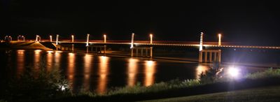
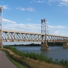
Discovery Bridge spans approximately 1,590 feet across the Missouri River, connecting Yankton, South Dakota to Cedar County, Nebraska by way of US Highway 81. The four-lane bridge measures about 74 feet wide and features decorative spires standing roughly 50 feet tall that are equipped with integrated lighting systems.

History

The bridge opened on October 11, 2008, replacing the Meridian Highway Bridge that had served the region for 84 years beginning in 1924. This new structure marked an important moment for direct connections between the two states.

Culture

The bridge takes its name from the Lewis and Clark expedition, which was called the Corps of Discovery. This name was chosen through a public naming contest that connected the crossing to the region's exploration heritage.

Practical

The bridge functions as part of an important transportation corridor serving regular traffic between the two states. The integrated lighting system makes it particularly worth viewing during evening hours when the decorative spires are illuminated.

Did you know?

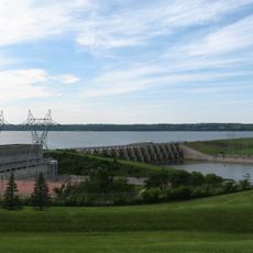
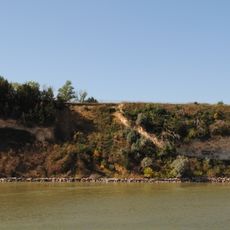
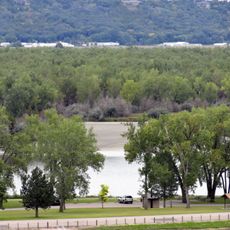
The bridge crosses over the Missouri National Recreational River, a federally protected waterway managed by the National Park Service. This designation makes the crossing part of an important conservation area where the river is preserved for public recreation.

Location
Location
Inception
October 11, 2008
Official opening
October 11, 2008
GPS coordinates
42.86510,-97.39700
Latest update
December 14, 2025 11:26

AroundUs brings together thousands of curated places, local tips, and hidden gems, enriched daily by 60,000 contributors worldwide. Discover all places nearby (Nebraska).

Around this place
Lewis and Clark Lake
United States of America

Lewis and Clark Lake

7.7 km
Missouri National Recreational River
United States of America

Missouri National Recreational River

450 m
Human Services Center
United States of America

Human Services Center

6 km
United States of America

Lewis and Clark State Recreation Area

15.1 km
Calumet Bluff
United States of America

Calumet Bluff

7.2 km
Immaculate Conception Catholic Church and Rectory
United States of America

Immaculate Conception Catholic Church and Rectory

13.7 km
Gavins Point National Fish Hatchery
United States of America

Gavins Point National Fish Hatchery

6.4 km
St. Rose of Lima Catholic Church and School Complex
United States of America

St. Rose of Lima Catholic Church and School Complex

17.3 km
Governor John L. Pennington House
United States of America

Governor John L. Pennington House

1.1 km
Training Dike Recreation Area
United States of America

Training Dike Recreation Area

6.4 km
United Church of Christ
United States of America

United Church of Christ

11.6 km
Cottonwood Recreation Area
United States of America

Cottonwood Recreation Area

7 km
Vangen Church
United States of America

Vangen Church

12.8 km
Ohlman-Shannon House
United States of America

Ohlman-Shannon House

640 m
St. Boniface Catholic Church Complex
United States of America

St. Boniface Catholic Church Complex

9 km
Yankton Carnegie Library
United States of America

Yankton Carnegie Library

876 m
Van Osdel House
United States of America

Van Osdel House

11.3 km
William J. Fantle House
United States of America

William J. Fantle House

2 km
Harold A. Doyle House
United States of America

Harold A. Doyle House

717 m
Burns House
United States of America

Burns House

1.6 km
Dr. John Trierweiler House
United States of America

Dr. John Trierweiler House

821 m
Bishop Marty Rectory
United States of America

Bishop Marty Rectory

1.1 km
Dr. B.M. Banton House
United States of America

Dr. B.M. Banton House

943 m
Bruce-Donaldson House
United States of America

Bruce-Donaldson House

898 m
William Andre House
United States of America

William Andre House

19.4 km
Fred Schnauber House
United States of America

Fred Schnauber House

1.3 km
DeJong House
United States of America

DeJong House

15.3 km
Meridian Highway Bridge
United States of America

Meridian Highway Bridge

251 m
Show the full map
« Discovery Bridge - Road bridge between Nebraska and South Dakota, United States » is provided by Around Us (aroundus.com). Images and texts are derived from Wikimedia project under a Creative Commons license. You are allowed to copy, distribute, and modify copies of this page, under the conditions set by the license, as long as this note is clearly visible.

Discover hidden gems everywhere you go!

From secret cafés to breathtaking viewpoints, skip the crowded tourist spots and find places that match your style. Our app makes it easy with voice search, smart filtering, route optimization, and insider tips from travelers worldwide. Download now for the complete mobile experience.

Around Us App Screenshot

A unique approach to discovering new places

Le Figaro

All the places worth exploring

France Info

A tailor-made excursion in just a few clicks

20 Minutes

Around Us
Travel Guide & Maps
Download

Send to your phone

QR Code
1

Open the camera app on your mobile.

2

Point at the QR code with your camera. A notification will appear.

3

Tap the notification to open the link.