Palms Book State Park

Log in to your account

AroundUs is a community-driven map of interesting places, built by curious explorers like you. It grows with every review, story, and photo you share.
Connect to save your favorite spots, contribute locations, and create personalized routes.
Continue with Google
Continue with Apple
Continue with X
Continue with Facebook
Continue with email
By continuing, you accept our Terms and Conditions and our Privacy Policy
Create an account
Add to collection
Map
Suggest a change
Share

Palms Book State Park, Natural spring park in Thompson Township, Michigan, United States.

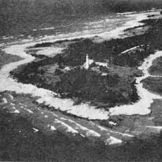
Palms Book State Park is a natural spring park in Thompson Township in northern Michigan that centers on a large freshwater spring. The spring, called Kitch-iti-kipi, spreads across about 200 feet and reaches depths around 40 feet, with water continuously flowing from limestone cracks beneath the surface.

A landowner named John Bellaire sold the property to Michigan state in 1926 for a nominal price, creating the foundation for this protected area. The state later developed the site into a public park where visitors could safely access the spring.

The spring holds deep meaning for Native American tribes, particularly the Ojibwe, who traditionally used the sound of flowing water to inspire names for newborns. This cultural connection shapes how visitors and local communities understand and relate to the place.

An observation raft moves across the spring's surface, giving visitors a way to see underwater features through a self-operated system. Visitors should wear comfortable shoes and be prepared for a short walk through a natural setting to reach the viewing platform.

The spring maintains a constant temperature around 45 degrees Fahrenheit throughout the year regardless of season or weather. This stable environment supports plant and animal species that would not normally survive in this northern region.

Location: Michigan

Inception: 1926

Website: https://www2.dnr.state.mi.us/ParksandTrails/Details.aspx?id=425&type=SPRK

GPS coordinates: 46.00770,-86.37830

Latest update: December 9, 2025 18:42

Photos
Around this place
Fayette Historic State Park
United States of America

Fayette Historic State Park

39.1 km
Seney National Wildlife Refuge
United States of America

Seney National Wildlife Refuge

34.5 km
Grand Island East Channel Light
United States of America

Grand Island East Channel Light

53.4 km
Munising Falls
United States of America

Munising Falls

49.8 km
Seul Choix Light
United States of America

Seul Choix Light

37.3 km
Miners Falls
United States of America

Miners Falls

53.3 km
Indian Lake State Park
United States of America

Indian Lake State Park

8 km
Spider Cave
United States of America

Spider Cave

43.9 km
Wagner Falls Scenic Site
United States of America

Wagner Falls Scenic Site

47.1 km
Wagner Falls
United States of America

Wagner Falls

47.1 km
Manistique East Breakwater Light
United States of America

Manistique East Breakwater Light

12.3 km
Bridalveil Falls
United States of America

Bridalveil Falls

56.9 km
Tannery Falls
United States of America

Tannery Falls

49.3 km
Onota, Au Train Township, Michigan
United States of America

Onota, Au Train Township, Michigan

54.4 km
Munising Front Range Light
United States of America

Munising Front Range Light

50.3 km
Grand Island Harbor Rear Range Light
United States of America

Grand Island Harbor Rear Range Light

53.5 km
Munising Rear Range Light
United States of America

Munising Rear Range Light

50.1 km
Alger Falls
United States of America

Alger Falls

47.7 km
Manistique Pumping Station
United States of America

Manistique Pumping Station

11 km
Memorial Falls
United States of America

Memorial Falls

49.5 km
County Road I-39–Rapid River Bridge
United States of America

County Road I-39–Rapid River Bridge

46.5 km
Schoolcraft Furnace Site
United States of America

Schoolcraft Furnace Site

50 km
Lobb House
United States of America

Lobb House

49.7 km
Ekdahl–Goudreau Site
United States of America

Ekdahl–Goudreau Site

37.1 km
Sand Point Beach
United States of America

Sand Point Beach

52.1 km
Grand Island Harbor Front Range Light
United States of America

Grand Island Harbor Front Range Light

53.7 km
Nahma and Northern Railway no. 5
United States of America

Nahma and Northern Railway no. 5

28.9 km
Munising School Public Library
United States of America

Munising School Public Library

50.6 km
Show the full map
Reviews

Visited this place? Tap the stars to rate it and share your experience / photos with the community! Try now! You can cancel it anytime.

« Palms Book State Park - Natural spring park in Thompson Township, Michigan, United States » is provided by Around Us (aroundus.com). Images and texts are derived from Wikimedia project under a Creative Commons license. You are allowed to copy, distribute, and modify copies of this page, under the conditions set by the license, as long as this note is clearly visible.

Discover hidden gems everywhere you go!

From secret cafés to breathtaking viewpoints, skip the crowded tourist spots and find places that match your style. Our app makes it easy with voice search, smart filtering, route optimization, and insider tips from travelers worldwide. Download now for the complete mobile experience.

Around Us App Screenshot

A unique approach to discovering new places

Le Figaro

All the places worth exploring

France Info

A tailor-made excursion in just a few clicks

20 Minutes