Enable Location

We need your location to show you interesting places around you

Discover nearby places

Find interesting locations and hidden gems around you

Precise directions

Get accurate directions and distances to places

Your location is never shared with other users. It's only used when you tap the location button.

Red Wing Bridge

Log in to your account

Start exploring — it's free

Trusted by 61,909 travelers worldwide

Continue with Google
Continue with Apple
or

We will send you a code to connect

By continuing, you accept our Terms and Conditions and our Privacy Policy

Check your inbox

We've sent a pincode in your inbox. Please enter the code below.

Red Wing Bridge

Red Wing Bridge, Cantilever bridge in Red Wing, United States

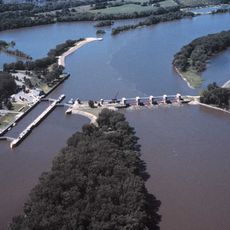
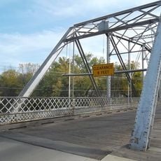
The Red Wing Bridge is a cantilever truss bridge crossing the Mississippi River between Wisconsin and Minnesota. The structure uses a Warren through truss design with riveted connections, representing engineering techniques from the mid-twentieth century.

The bridge opened in November 1960 with President Dwight D. Eisenhower attending the dedication ceremony, giving it the name Eisenhower Bridge. Structural concerns arose decades later following a major collapse nearby, eventually leading to its replacement.

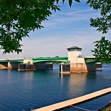
This crossing served as the main link between Wisconsin and Red Wing in Minnesota for local residents and commuters. People on both sides of the river depended on it for daily travel and trade.

The bridge provides direct road access between Wisconsin and Red Wing for vehicles. Visitors should remember this is an active traffic route and exercise appropriate caution when walking or stopping to observe the structure.

The original structure used riveted connections rather than modern welding methods, making it a rare example of classic bridge construction techniques. This allows visitors today to see an engineering method that has largely disappeared from contemporary practice.

The community of curious travelers

AroundUs brings together thousands of curated places, local tips, and hidden gems, enriched daily by 60,000 contributors worldwide.

Start exploring
Location
Location
Inception
November 1960
Official opening
November 1960
GPS coordinates
44.57000,-92.53390
Latest update
December 13, 2025 11:41
Around this place
Minnesota Correctional Facility – Red Wing
United States of America

Minnesota Correctional Facility – Red Wing

3.1 km
Pachyderm Studio
United States of America

Pachyderm Studio

27.3 km
Frontenac State Park
United States of America

Frontenac State Park

17.9 km
St. James Hotel
United States of America

St. James Hotel

470 m
Lock and Dam No. 3
United States of America

Lock and Dam No. 3

7.5 km
Fort Saint Antoine
United States of America

Fort Saint Antoine

27.2 km
Prescott Drawbridge
United States of America

Prescott Drawbridge

29.3 km
Sheldon Theatre
United States of America

Sheldon Theatre

686 m
Chimney Rock Scientific and Natural Area
United States of America

Chimney Rock Scientific and Natural Area

29.6 km
United States of America

Miesville Ravine Park Reserve

21.7 km
Vasa Children's Home
United States of America

Vasa Children's Home

8 km
Patrick H. Rahilly House
United States of America

Patrick H. Rahilly House

22.9 km
Immanuel Lutheran Church
United States of America

Immanuel Lutheran Church

8.7 km
Pierce County Courthouse
United States of America

Pierce County Courthouse

18.5 km
Cross of Christ Lutheran Church
United States of America

Cross of Christ Lutheran Church

15.9 km
Bear Valley Grange Hall
United States of America

Bear Valley Grange Hall

29 km
E. S. Hoyt House
United States of America

E. S. Hoyt House

1.1 km
Williamson–Russell–Rahilly House
United States of America

Williamson–Russell–Rahilly House

25.3 km
Lake City City Hall
United States of America

Lake City City Hall

25.2 km
Third Street Bridge
United States of America

Third Street Bridge

30 km
H. S. Miller Bank
United States of America

H. S. Miller Bank

29.2 km
James C. and Agnes M. Stout House
United States of America

James C. and Agnes M. Stout House

25.3 km
Bridge No. 12
United States of America

Bridge No. 12

8.2 km
Daniel Smith House
United States of America

Daniel Smith House

29.3 km
James L. Lawther House
United States of America

James L. Lawther House

1 km
World's Largest Boot
United States of America

World's Largest Boot

438 m
Red Wing Mall Historic District
United States of America

Red Wing Mall Historic District

778 m
Artesian wells ice sculptures
United States of America

Artesian wells ice sculptures

18.2 km
Show the full map
« Red Wing Bridge - Cantilever bridge in Red Wing, United States » is provided by Around Us (aroundus.com). Images and texts are derived from Wikimedia project under a Creative Commons license. You are allowed to copy, distribute, and modify copies of this page, under the conditions set by the license, as long as this note is clearly visible.

Discover hidden gems everywhere you go!

From secret cafés to breathtaking viewpoints, skip the crowded tourist spots and find places that match your style. Our app makes it easy with voice search, smart filtering, route optimization, and insider tips from travelers worldwide. Download now for the complete mobile experience.

Around Us App Screenshot

A unique approach to discovering new places

Le Figaro

All the places worth exploring

France Info

A tailor-made excursion in just a few clicks

20 Minutes

Around Us
Travel Guide & Maps
Download

Send to your phone

QR Code
1

Open the camera app on your mobile.

2

Point at the QR code with your camera. A notification will appear.

3

Tap the notification to open the link.