Enable Location

We need your location to show you interesting places around you

Discover nearby places

Find interesting locations and hidden gems around you

Precise directions

Get accurate directions and distances to places

Your location is never shared with other users. It's only used when you tap the location button.

Prescott Drawbridge

Log in to your account

Start exploring — it's free

Trusted by 61,908 travelers worldwide

Continue with Google
Continue with Apple
or

We will send you a code to connect

By continuing, you accept our Terms and Conditions and our Privacy Policy

Check your inbox

We've sent a pincode in your inbox. Please enter the code below.

Prescott Drawbridge

Prescott Drawbridge, Steel drawbridge in Prescott, United States.

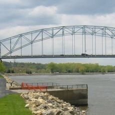
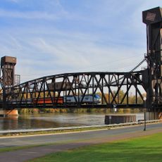
Prescott Drawbridge is a steel structure crossing the St. Croix River between Wisconsin and Minnesota, distributing traffic across four lanes. The bridge operates as a movable lift bridge and is part of a dual crossing system that also includes a railway bridge alongside it.

An earlier bridge built in 1922 originally served this crossing as a toll facility until it was replaced in 1990 by the current structure. This replacement marked a major upgrade to the region's transportation infrastructure.

The bridge represents a significant infrastructure development in the Minneapolis-Saint Paul metropolitan area, being the only operational highway drawbridge.

The bridge supports U.S. Route 10 and experiences steady daily traffic, serving as a key connection between the two states. Keep in mind that it is an active transportation corridor and passage may be affected when the bridge lifts for river traffic.

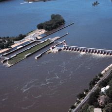
What makes this crossing distinctive is the side-by-side operation of two separate bridge systems designed for different purposes at the exact same riverbed location. This arrangement shows how different transportation modes can coexist and solve the same obstacle in parallel.

The community of curious travelers

AroundUs brings together thousands of curated places, local tips, and hidden gems, enriched daily by 60,000 contributors worldwide.

Start exploring
Location
Location
Inception
1990
Official opening
1990
GPS coordinates
44.74890,-92.80470
Latest update
December 14, 2025 13:08
Around this place
Afton State Park
United States of America

Afton State Park

12.8 km
Lock and Dam No. 2
United States of America

Lock and Dam No. 2

5.2 km
Kinnickinnic State Park
United States of America

Kinnickinnic State Park

10 km
Hastings High Bridge
United States of America

Hastings High Bridge

3.8 km
William G. LeDuc House
United States of America

William G. LeDuc House

4.3 km
Ramsey Mill and Old Mill Park
United States of America

Ramsey Mill and Old Mill Park

3.9 km
Hastings Rail Bridge
United States of America

Hastings Rail Bridge

3.4 km
Cordenio Severance House
United States of America

Cordenio Severance House

13.7 km
East Second Street Commercial Historic District
United States of America

East Second Street Commercial Historic District

3.6 km
Chimney Rock Scientific and Natural Area
United States of America

Chimney Rock Scientific and Natural Area

14.2 km
Reuben Freeman House
United States of America

Reuben Freeman House

18.9 km
VanDyke–Libby House
United States of America

VanDyke–Libby House

4 km
Dakota County Courthouse
United States of America

Dakota County Courthouse

3.8 km
Cross of Christ Lutheran Church
United States of America

Cross of Christ Lutheran Church

17.6 km
First Presbyterian Church
United States of America

First Presbyterian Church

3.9 km
Norrish House
United States of America

Norrish House

4 km
West Second Street Residential Historic District
United States of America

West Second Street Residential Historic District

4 km
Hastings Methodist Episcopal Church
United States of America

Hastings Methodist Episcopal Church

3.9 km
Ignatius Eckert House
United States of America

Ignatius Eckert House

4.2 km
John P. Furber House
United States of America

John P. Furber House

12.2 km
North Hall-River Falls State Normal School
United States of America

North Hall-River Falls State Normal School

18.6 km
Byron Howes House
United States of America

Byron Howes House

4 km
District No. 34 School
United States of America

District No. 34 School

1 km
South Hall
United States of America

South Hall

18.5 km
H. S. Miller Bank
United States of America

H. S. Miller Bank

217 m
MacDonald–Todd House
United States of America

MacDonald–Todd House

4.2 km
Newington Gilbert House
United States of America

Newington Gilbert House

19.6 km
Daniel Smith House
United States of America

Daniel Smith House

226 m
Show the full map
« Prescott Drawbridge - Steel drawbridge in Prescott, United States » is provided by Around Us (aroundus.com). Images and texts are derived from Wikimedia project under a Creative Commons license. You are allowed to copy, distribute, and modify copies of this page, under the conditions set by the license, as long as this note is clearly visible.

Discover hidden gems everywhere you go!

From secret cafés to breathtaking viewpoints, skip the crowded tourist spots and find places that match your style. Our app makes it easy with voice search, smart filtering, route optimization, and insider tips from travelers worldwide. Download now for the complete mobile experience.

Around Us App Screenshot

A unique approach to discovering new places

Le Figaro

All the places worth exploring

France Info

A tailor-made excursion in just a few clicks

20 Minutes

Around Us
Travel Guide & Maps
Download

Send to your phone

QR Code
1

Open the camera app on your mobile.

2

Point at the QR code with your camera. A notification will appear.

3

Tap the notification to open the link.