Enable Location

We need your location to show you interesting places around you

Discover nearby places

Find interesting locations and hidden gems around you

Precise directions

Get accurate directions and distances to places

Your location is never shared with other users. It's only used when you tap the location button.

Chimney Rock Scientific and Natural Area

Log in to your account

Start exploring — it's free

Trusted by 61,912 travelers worldwide

Continue with Google
Continue with Apple
or

We will send you a code to connect

By continuing, you accept our Terms and Conditions and our Privacy Policy

Check your inbox

We've sent a pincode in your inbox. Please enter the code below.

Chimney Rock Scientific and Natural Area

Chimney Rock Scientific and Natural Area, Protected natural area in Dakota County, Minnesota.

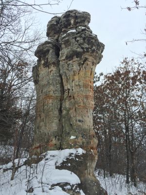
Chimney Rock Scientific and Natural Area is a protected nature preserve in Dakota County featuring a distinctive 30-foot sandstone tower with a limestone cap. This 76-acre site displays the geological forces that shaped the landscape through ancient water erosion patterns.

The site was acquired in 2011 by the Minnesota Department of Natural Resources and Dakota County to protect it for future generations. The sandstone formation itself developed over thousands of years through the erosive action of glacial melt water.

The sandstone formation served as a geographical reference point for settlers moving into Dakota County territory during the nineteenth century expansion period.

The site is best visited during dry weather since the ground becomes muddy after rainfall. Walking is straightforward on natural terrain, though visitors should watch their footing on uneven surfaces.

Four rare plant species thrive within this protected area, drawing researchers and botanists for field studies. This botanical importance makes it a valuable research location for understanding Minnesota's natural heritage.

The community of curious travelers

AroundUs brings together thousands of curated places, local tips, and hidden gems, enriched daily by 60,000 contributors worldwide.

Start exploring
Location
GPS coordinates
44.63822,-92.89447
Latest update
December 14, 2025 16:42
Around this place
Pachyderm Studio
United States of America

Pachyderm Studio

11.9 km
Lock and Dam No. 2
United States of America

Lock and Dam No. 2

13.7 km
Hastings High Bridge
United States of America

Hastings High Bridge

12.5 km
William G. LeDuc House
United States of America

William G. LeDuc House

10.7 km
Ramsey Mill and Old Mill Park
United States of America

Ramsey Mill and Old Mill Park

10.7 km
Hastings Rail Bridge
United States of America

Hastings Rail Bridge

12.6 km
Prescott Drawbridge
United States of America

Prescott Drawbridge

14.2 km
East Second Street Commercial Historic District
United States of America

East Second Street Commercial Historic District

12.3 km
United States of America

Miesville Ravine Park Reserve

12.6 km
Vasa Children's Home
United States of America

Vasa Children's Home

22 km
VanDyke–Libby House
United States of America

VanDyke–Libby House

11.7 km
Exchange Bank Building
United States of America

Exchange Bank Building

19.9 km
Church of the Advent
United States of America

Church of the Advent

19.6 km
Dakota County Courthouse
United States of America

Dakota County Courthouse

12.1 km
Cross of Christ Lutheran Church
United States of America

Cross of Christ Lutheran Church

13.7 km
First Presbyterian Church
United States of America

First Presbyterian Church

11.8 km
Norrish House
United States of America

Norrish House

12.2 km
West Second Street Residential Historic District
United States of America

West Second Street Residential Historic District

12.2 km
Hastings Methodist Episcopal Church
United States of America

Hastings Methodist Episcopal Church

11.6 km
Ignatius Eckert House
United States of America

Ignatius Eckert House

11.8 km
Byron Howes House
United States of America

Byron Howes House

11.7 km
District No. 34 School
United States of America

District No. 34 School

14 km
Third Street Bridge
United States of America

Third Street Bridge

13.9 km
H. S. Miller Bank
United States of America

H. S. Miller Bank

14.4 km
MacDonald–Todd House
United States of America

MacDonald–Todd House

11.6 km
Daniel Smith House
United States of America

Daniel Smith House

14.4 km
Lake Byllesby Regional Park
United States of America

Lake Byllesby Regional Park

14.1 km
Lake Byllesby
United States of America

Lake Byllesby

14.8 km
Show the full map
« Chimney Rock Scientific and Natural Area - Protected natural area in Dakota County, Minnesota » is provided by Around Us (aroundus.com). Images and texts are derived from Wikimedia project under a Creative Commons license. You are allowed to copy, distribute, and modify copies of this page, under the conditions set by the license, as long as this note is clearly visible.

Discover hidden gems everywhere you go!

From secret cafés to breathtaking viewpoints, skip the crowded tourist spots and find places that match your style. Our app makes it easy with voice search, smart filtering, route optimization, and insider tips from travelers worldwide. Download now for the complete mobile experience.

Around Us App Screenshot

A unique approach to discovering new places

Le Figaro

All the places worth exploring

France Info

A tailor-made excursion in just a few clicks

20 Minutes

Around Us
Travel Guide & Maps
Download

Send to your phone

QR Code
1

Open the camera app on your mobile.

2

Point at the QR code with your camera. A notification will appear.

3

Tap the notification to open the link.