Enable Location

We need your location to show you interesting places around you

Discover nearby places

Find interesting locations and hidden gems around you

Precise directions

Get accurate directions and distances to places

Your location is never shared with other users. It's only used when you tap the location button.

Hastings High Bridge

Log in to your account

Start exploring — it's free

Trusted by 62,934 travelers worldwide

Continue with Google
Continue with Apple
or

We will send you a code to connect

By continuing, you accept our Terms and Conditions and our Privacy Policy

Check your inbox

We've sent a pincode in your inbox. Please enter the code below.

Hastings High Bridge
Discussion Reviews 1 Photos
3.5k Popularity

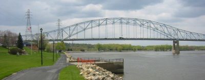
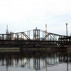
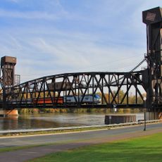
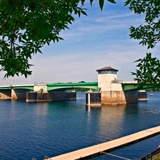
Hastings High Bridge, Steel truss bridge in Hastings, Minnesota.

Hastings High Bridge was a steel truss structure spanning the Mississippi River with a total length of approximately 1,857 feet. It connected both riverbanks using a through-truss design that carried road traffic between the communities on either side.

The structure was completed in 1951 and replaced an earlier spiral bridge that had served the community since 1895. The original crossing had become a landmark of the region after decades of use.

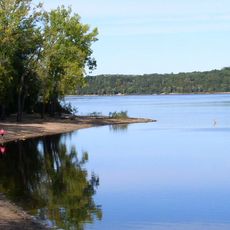
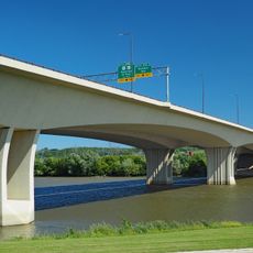
The bridge remains a central element of Hastings infrastructure, connecting communities on both sides of the Mississippi River while providing observation points.

The bridge was replaced in 2013 by a newer structure, but the historic site offers stopping points for viewing the river and surrounding area. Visitors can explore the river and landscape from various access points along both banks.

The bridge underwent heightened inspections following the I-35W bridge collapse in Minneapolis in 2007. These reviews raised concerns about its load capacity and helped accelerate the decision to replace it.

The community of curious travelers

AroundUs brings together thousands of curated places, local tips, and hidden gems, enriched daily by 60,000 contributors worldwide.

Start exploring
Location
Inception
1951
Official opening
1951
GPS coordinates
44.74640,-92.85280
Latest update
December 12, 2025 07:56
Around this place
Afton State Park
United States of America

Afton State Park

14 km
Lock and Dam No. 2
United States of America

Lock and Dam No. 2

1.9 km
Kinnickinnic State Park
United States of America

Kinnickinnic State Park

12.3 km
Rock Island Swing Bridge
United States of America

Rock Island Swing Bridge

17.1 km
Wakota Bridge
United States of America

Wakota Bridge

19.9 km
William G. LeDuc House
United States of America

William G. LeDuc House

1.9 km
Ramsey Mill and Old Mill Park
United States of America

Ramsey Mill and Old Mill Park

2.3 km
Hastings Rail Bridge
United States of America

Hastings Rail Bridge

397 m
Prescott Drawbridge
United States of America

Prescott Drawbridge

3.8 km
Cordenio Severance House
United States of America

Cordenio Severance House

12.1 km
East Second Street Commercial Historic District
United States of America

East Second Street Commercial Historic District

297 m
Chimney Rock Scientific and Natural Area
United States of America

Chimney Rock Scientific and Natural Area

12.5 km
Reuben Freeman House
United States of America

Reuben Freeman House

15.6 km
VanDyke–Libby House
United States of America

VanDyke–Libby House

762 m
Dakota County Courthouse
United States of America

Dakota County Courthouse

435 m
Cross of Christ Lutheran Church
United States of America

Cross of Christ Lutheran Church

19 km
First Presbyterian Church
United States of America

First Presbyterian Church

698 m
Norrish House
United States of America

Norrish House

340 m
West Second Street Residential Historic District
United States of America

West Second Street Residential Historic District

340 m
Hastings Methodist Episcopal Church
United States of America

Hastings Methodist Episcopal Church

884 m
Ignatius Eckert House
United States of America

Ignatius Eckert House

710 m
John P. Furber House
United States of America

John P. Furber House

11 km
Byron Howes House
United States of America

Byron Howes House

825 m
District No. 34 School
United States of America

District No. 34 School

2.9 km
H. S. Miller Bank
United States of America

H. S. Miller Bank

4 km
MacDonald–Todd House
United States of America

MacDonald–Todd House

847 m
Newington Gilbert House
United States of America

Newington Gilbert House

20.2 km
Daniel Smith House
United States of America

Daniel Smith House

4 km
Show the full map
Reviews
Share your experience

No review yet

Discussions
Start a discussion...

No discussion yet

« Hastings High Bridge - Steel truss bridge in Hastings, Minnesota » is provided by Around Us (aroundus.com). Images and texts are derived from Wikimedia project under a Creative Commons license. You are allowed to copy, distribute, and modify copies of this page, under the conditions set by the license, as long as this note is clearly visible.

Discover hidden gems everywhere you go!

From secret cafés to breathtaking viewpoints, skip the crowded tourist spots and find places that match your style. Our app makes it easy with voice search, smart filtering, route optimization, and insider tips from travelers worldwide. Download now for the complete mobile experience.

Around Us App Screenshot

A unique approach to discovering new places

Le Figaro

All the places worth exploring

France Info

A tailor-made excursion in just a few clicks

20 Minutes

Around Us
Travel Guide & Maps
Download

Send to your phone

QR Code
1

Open the camera app on your mobile.

2

Point at the QR code with your camera. A notification will appear.

3

Tap the notification to open the link.