Chest opened
+${chestReward.xp} XP
Explorer
NOUVEAU ×${chestReward.collectible.quantity}
tapez pour fermer
Chest locked

Open chests in the app

Around Us is built for your phone — chests unlock when you walk, explore and capture nearby places.

Enable Location

We need your location to show you interesting places around you

Discover nearby places

Find interesting locations and hidden gems around you

Precise directions

Get accurate directions and distances to places

Your location is never shared with other users. It's only used when you tap the location button.

Log in to your account

Start exploring — it's free

Trusted by 72,888 travelers worldwide

Continue with Google
Continue with Apple
or

We will send you a code to connect

By continuing, you accept our Terms and Conditions and our Privacy Policy

Check your inbox

We've sent a pincode in your inbox. Please enter the code below.

Selmier State Forest
Discussion Reviews Photo
1.5k Popularity

Selmier State Forest, state forest in Indiana, U.S

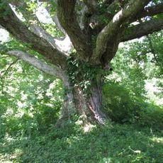
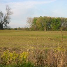
Selmier State Forest is a 355-acre woodland in Indiana with pines, hickory, and oak trees spreading across gentle hills and open areas. The forest lies near the Muscatatuck River and is accessible through several marked trails.

The land became state forest in 1944 after Stella Selmier donated it in honor of her husband Frank, who planted various tree species from 1921 to 1934. The woodland was incorporated into Indiana's Classified Forest Program and has been managed as protected land ever since.

The forest was planted by Frank Selmier, whose love for the outdoors lives on in the trees he set between 1921 and 1934. Visitors today can still see pines, black walnuts, and tulip trees that reflect his vision of a managed woodland.

The forest is open daily from sunrise to sunset with no entrance fee and no facilities such as bathrooms or camping areas. Visitors should wear sturdy shoes and bring water, especially when hiking longer distances.

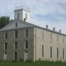
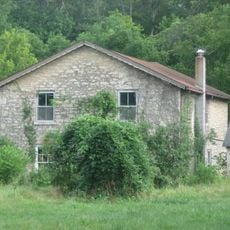
Within the forest stand historical buildings such as an old boy scout cabin and a former schoolhouse that can be found along the Walnut Trail. These structures tell of earlier uses of the land and offer visitors glimpses into the lived history of the woodland area.

The community of curious travelers

AroundUs brings together thousands of curated places, local tips, and hidden gems, enriched daily by 60,000 contributors worldwide.

Start exploring
Location
GPS coordinates
39.03000,-85.60190
Latest update
February 9, 2026 08:19
Around this place
Muscatatuck Urban Training Center
United States of America

Muscatatuck Urban Training Center

6.2 km
Freeman Field Mutiny
United States of America

Freeman Field Mutiny

29 km
Big Oaks National Wildlife Refuge
United States of America

Big Oaks National Wildlife Refuge

19.6 km
Muscatatuck National Wildlife Refuge
United States of America

Muscatatuck National Wildlife Refuge

20.9 km
Eleutherian College
United States of America

Eleutherian College

23.4 km
Mabel McDowell Adult Education Center
United States of America

Mabel McDowell Adult Education Center

31.5 km
Bell Ford Covered Bridge
United States of America

Bell Ford Covered Bridge

29 km
Straber Ford Bridge
United States of America

Straber Ford Bridge

24.5 km
First Presbyterian Church
United States of America

First Presbyterian Church

26.3 km
Collin's Ford Bridge
United States of America

Collin's Ford Bridge

20.2 km
Tyson United Methodist Church
United States of America

Tyson United Methodist Church

30.4 km
Westport Covered Bridge
United States of America

Westport Covered Bridge

16 km
Lyman and Asenath Hoyt House
United States of America

Lyman and Asenath Hoyt House

23.1 km
Ripley County Courthouse
United States of America

Ripley County Courthouse

30.6 km
Versailles School and Tyson Auditorium
United States of America

Versailles School and Tyson Auditorium

30.3 km
Annadale
United States of America

Annadale

2.7 km
Central House
United States of America

Central House

30.6 km
Rising Sun Historic District
United States of America

Rising Sun Historic District

23.5 km
Farmers Club
United States of America

Farmers Club

26.1 km
George H. Vehslage House
United States of America

George H. Vehslage House

26.2 km
Seymour Commercial Historic District
United States of America

Seymour Commercial Historic District

26.1 km
Elias Conwell House
United States of America

Elias Conwell House

30.6 km
T. Harlan and Helen Montgomery House
United States of America

T. Harlan and Helen Montgomery House

26.3 km
Vernon Historic District
United States of America

Vernon Historic District

5.3 km
Fernando G. Taylor House
United States of America

Fernando G. Taylor House

30.7 km
Labyrinth
United States of America

Labyrinth

4.1 km
Hayden Historical Museum
United States of America

Hayden Historical Museum

12.7 km
James Covered Bridge
United States of America

James Covered Bridge

15.3 km
Show the full map
Reviews
Share your experience

No review yet

Discussions
Start a discussion...

No discussion yet

« Selmier State Forest - state forest in Indiana, U.S » is provided by Around Us (aroundus.com). Images and texts are derived from Wikimedia project under a Creative Commons license. You are allowed to copy, distribute, and modify copies of this page, under the conditions set by the license, as long as this note is clearly visible.

Discover hidden gems everywhere you go!

From secret cafés to breathtaking viewpoints, skip the crowded tourist spots and find places that match your style. Our app makes it easy with voice search, smart filtering, route optimization, and insider tips from travelers worldwide. Download now for the complete mobile experience.

Around Us App Screenshot

A unique approach to discovering new places

Le Figaro

All the places worth exploring

France Info

A tailor-made excursion in just a few clicks

20 Minutes

Around Us
Travel Guide & Maps
Download

Send to your phone

QR Code
1

Open the camera app on your mobile.

2

Point at the QR code with your camera. A notification will appear.

3

Tap the notification to open the link.