Enable Location

We need your location to show you interesting places around you

Discover nearby places

Find interesting locations and hidden gems around you

Precise directions

Get accurate directions and distances to places

Your location is never shared with other users. It's only used when you tap the location button.

Log in to your account

Start exploring — it's free

Trusted by 61,868 travelers worldwide

Continue with Google
Continue with Apple
or

We will send you a code to connect

By continuing, you accept our Terms and Conditions and our Privacy Policy

Check your inbox

We've sent a pincode in your inbox. Please enter the code below.

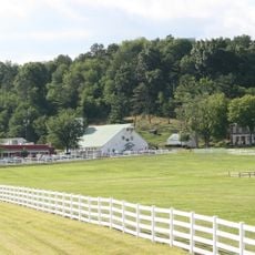
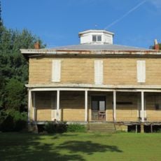
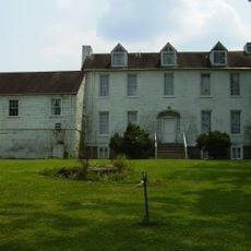
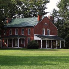
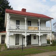
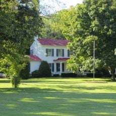
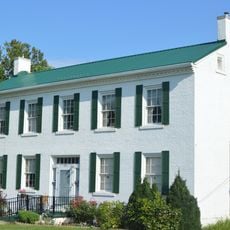
Smithland Farm, Greek Revival building in Mason County, West Virginia

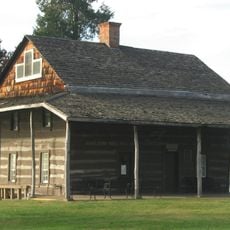
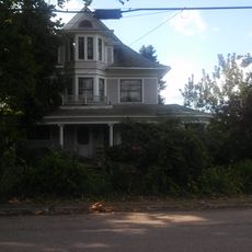
Smithland Farm is a two-story frame house with weatherboard siding and a side-gabled roof located near Henderson in Mason County. The property encompasses several outbuildings that reflect the working needs of a rural homestead across different time periods.

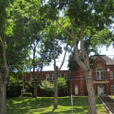
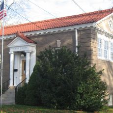
The property was owned by General John McCausland until 1981, when the West Virginia Department of Agriculture took over stewardship for preservation. The block school building was constructed between 1915 and 1920 during an era of expanding rural education.

The property contains multiple structures including a corncrib from 1950, a silo from 1930, and the Poffenbarger Cemetery from the late 1900s.

The farm is located along U.S. Route 35 between Lower Nine Mile Road and Lower Five Mile Road, making it easy to spot from the highway. Visitors should plan to explore multiple buildings spread across the property to see the full scope of the site.

The property includes a Poffenbarger Cemetery dating to the late 1800s, preserving family burial grounds right on the farmstead. This burial site reflects how rural properties historically combined residence, work, and family heritage in one place.

The community of curious travelers

AroundUs brings together thousands of curated places, local tips, and hidden gems, enriched daily by 60,000 contributors worldwide.

Start exploring
Location
Architectural style
Greek Revival architecture
GPS coordinates
38.77830,-82.05060
Latest update
December 14, 2025 18:02
Around this place
Silver Memorial Bridge
United States of America

Silver Memorial Bridge

10.5 km
Fort Randolph
United States of America

Fort Randolph

9.1 km
Tu-Endie-Wei State Park
United States of America

Tu-Endie-Wei State Park

10.4 km
Wood Old Homestead
United States of America

Wood Old Homestead

29.8 km
Mothman Museum
United States of America

Mothman Museum

10.5 km
Pomeroy–Mason Bridge
United States of America

Pomeroy–Mason Bridge

26.2 km
Gen. John McCausland House
United States of America

Gen. John McCausland House

15.2 km
Robert C. Byrd Lock and Dam
United States of America

Robert C. Byrd Lock and Dam

16.2 km
Gen. Albert Gallatin Jenkins House
United States of America

Gen. Albert Gallatin Jenkins House

27.4 km
Racine Lock and Dam
United States of America

Racine Lock and Dam

19.6 km
Point Pleasant Rail Bridge
United States of America

Point Pleasant Rail Bridge

10.9 km
Meigs County Courthouse
United States of America

Meigs County Courthouse

27.8 km
Point Pleasant Historic District
United States of America

Point Pleasant Historic District

10.6 km
Lewis-Capehart-Roseberry House
United States of America

Lewis-Capehart-Roseberry House

13.2 km
Putnam County Courthouse
United States of America

Putnam County Courthouse

30.5 km
Gallia County Courthouse
United States of America

Gallia County Courthouse

13.6 km
The Gold Houses
United States of America

The Gold Houses

27.5 km
John Downing, Jr., House
United States of America

John Downing, Jr., House

25.1 km
James W. Hoge House
United States of America

James W. Hoge House

30.6 km
Middleport Public Library
United States of America

Middleport Public Library

24.7 km
Shumaker-Lewis House
United States of America

Shumaker-Lewis House

26.9 km
Couch-Artrip House
United States of America

Couch-Artrip House

11 km
William H. Grant House
United States of America

William H. Grant House

24.7 km
Clerc-Carson House
United States of America

Clerc-Carson House

30.2 km
Armstrong House
United States of America

Armstrong House

29.5 km
Powell-Redmond House
United States of America

Powell-Redmond House

24.9 km
Winfield Toll Bridge
United States of America

Winfield Toll Bridge

30.2 km
Ripley Historic District
United States of America

Ripley Historic District

29.9 km
Show the full map
« Smithland Farm - Greek Revival building in Mason County, West Virginia » is provided by Around Us (aroundus.com). Images and texts are derived from Wikimedia project under a Creative Commons license. You are allowed to copy, distribute, and modify copies of this page, under the conditions set by the license, as long as this note is clearly visible.

Discover hidden gems everywhere you go!

From secret cafés to breathtaking viewpoints, skip the crowded tourist spots and find places that match your style. Our app makes it easy with voice search, smart filtering, route optimization, and insider tips from travelers worldwide. Download now for the complete mobile experience.

Around Us App Screenshot

A unique approach to discovering new places

Le Figaro

All the places worth exploring

France Info

A tailor-made excursion in just a few clicks

20 Minutes

Around Us
Travel Guide & Maps
Download

Send to your phone

QR Code
1

Open the camera app on your mobile.

2

Point at the QR code with your camera. A notification will appear.

3

Tap the notification to open the link.