Enable Location

We need your location to show you interesting places around you

Discover nearby places

Find interesting locations and hidden gems around you

Precise directions

Get accurate directions and distances to places

Your location is never shared with other users. It's only used when you tap the location button.

State Street Historic District

Log in to your account

Join the adventure

Create your free account and start exploring (like 60k+ others)

We will send you a code to connect

or
Continue with Google
Continue with Apple
By continuing, you accept our Terms and Conditions and our Privacy Policy

Check your inbox

We've sent a pincode in your inbox. Please enter the code below.

State Street Historic District, Commercial historic district in Rochester, US.

Description

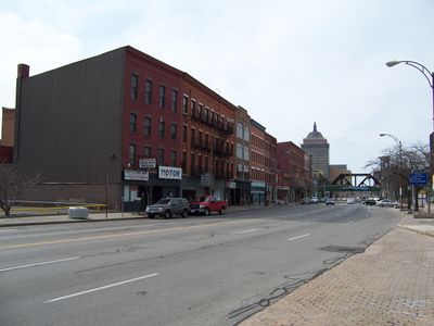
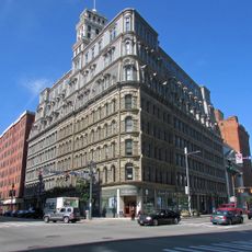
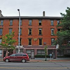
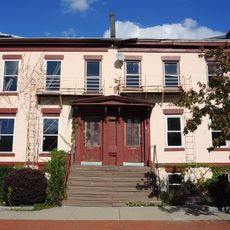
The State Street Historic District is a row of twelve connected brick commercial buildings in downtown Rochester with Federal and regional design features. These structures form an unbroken line of buildings from the 1800s that still retain their original details and proportions.

History

These buildings were constructed between 1825 and 1900 as Rochester expanded economically and merchants built their commercial spaces downtown. The oldest structure dates to the beginning of this growth period.

Culture

The buildings show how business owners in the 1800s designed their storefronts and how craftspeople expressed their skills through stone and woodwork. Walking along the street, you can see the materials and styles that merchants valued at that time.

Practical

The buildings are visible from the street and show their original facades and details from the sidewalk. It is best to visit during daylight hours when you can clearly see the architectural features and materials.

Did you know?

This is the last remaining continuous row of 1800s commercial buildings still standing in Rochester's downtown, surprisingly preserved amid modern development. The fact that this block survived intact while many other old streets were demolished makes it a rare window into the city's past.

Location
GPS coordinates
43.15750,-77.61528
Latest update
December 12, 2025 17:41

AroundUs brings together thousands of curated places, local tips, and hidden gems, enriched daily by 60,000 contributors worldwide. Discover all places nearby (New York).

Around this place
Kodak Tower
United States of America

Kodak Tower

518 m
Times Square Building
United States of America

Times Square Building

394 m
High Falls
United States of America

High Falls

451 m
First Federal Plaza
United States of America

First Federal Plaza

319 m
Broad Street Bridge
United States of America

Broad Street Bridge

547 m
Powers Building
United States of America

Powers Building

244 m
Hyatt Regency Rochester
United States of America

Hyatt Regency Rochester

562 m
Rundel Memorial Library
United States of America

Rundel Memorial Library

499 m
Rochester City Hall
United States of America

Rochester City Hall

66 m
Gannett Building
United States of America

Gannett Building

461 m
Brown's Race Historic District
United States of America

Brown's Race Historic District

352 m
City Hall Historic District
United States of America

City Hall Historic District

358 m
Wilder Building
United States of America

Wilder Building

350 m
Reynolds Arcade
United States of America

Reynolds Arcade

310 m
Main Street Bridge
United States of America

Main Street Bridge

393 m
Our Lady of Victory Roman Catholic Church
United States of America

Our Lady of Victory Roman Catholic Church

520 m
Chamber of Commerce
United States of America

Chamber of Commerce

430 m
First Presbyterian Church
United States of America

First Presbyterian Church

526 m
Bevier Memorial Building
United States of America

Bevier Memorial Building

473 m
First National Bank of Rochester-Old Monroe County Savings Bank Building
United States of America

First National Bank of Rochester-Old Monroe County Savings Bank Building

206 m
Brick Presbyterian Church Complex
United States of America

Brick Presbyterian Church Complex

135 m
Andrews Street Bridge
United States of America

Andrews Street Bridge

273 m
Jonathan Child House & Brewster–Burke House Historic District
United States of America

Jonathan Child House & Brewster–Burke House Historic District

543 m
Ebenezer Watts House
United States of America

Ebenezer Watts House

447 m
Central Trust Bank Building
United States of America

Central Trust Bank Building

404 m
German United Evangelical Church Complex
United States of America

German United Evangelical Church Complex

583 m
Bridge Square Historic District
United States of America

Bridge Square Historic District

426 m
Washington Street Rowhouses
United States of America

Washington Street Rowhouses

275 m
Show the full map
« State Street Historic District - Commercial historic district in Rochester, US » is provided by Around Us (aroundus.com). Images and texts are derived from Wikimedia project under a Creative Commons license. You are allowed to copy, distribute, and modify copies of this page, under the conditions set by the license, as long as this note is clearly visible.

Discover hidden gems everywhere you go!

From secret cafés to breathtaking viewpoints, skip the crowded tourist spots and find places that match your style. Our app makes it easy with voice search, smart filtering, route optimization, and insider tips from travelers worldwide. Download now for the complete mobile experience.

Around Us App Screenshot

A unique approach to discovering new places

Le Figaro

All the places worth exploring

France Info

A tailor-made excursion in just a few clicks

20 Minutes

Around Us
Travel Guide & Maps
Download

Send to your phone

QR Code
1

Open the camera app on your mobile.

2

Point at the QR code with your camera. A notification will appear.

3

Tap the notification to open the link.